
September 2010
John Vincent Bellezza
Welcome onboard as this month’s Flight of the Khyung traces a path over both upper and central Tibet. This issue features a potpourri of monumental and artistic evidence, furnishing more insights into the cultural complexion of the ancient Tibetan Plateau. Have a look and if you have any comments or observations, please get back to me (jbellezza@hotmail.com).
Altogether then: cosmogonic symbolism in prehistoric Upper Tibet
Upper Tibet, the vast region known as Toe (Stod) and Changthang (Byang thang) to the Tibetans, was welded together in antiquity by a group of closely related cultural regimes. According to Tibetan historical accounts, the two most dominant cultures of Upper Tibet were Zhang Zhung and Sumpa. While the assemblages of ceremonial monuments associated with their territorial purview differ significantly, these two cultures shared many architectural and esthetic traits in common.
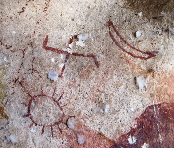
The swastika, sun and moon painted in red ochre, probably datable to the Iron Age.
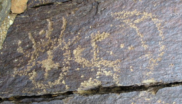
The swastika, sun and moon carved in stone, protohistoric period.
The common links between Sumpa and Zhang Zhung are nicely epitomized in a rock art motif chronicled on the Upper Tibetan Rock Art Expedition (UTRAE). This ostensible cosmogonic motif consists of a counterclockwise swastika flanked by a sun and crescent moon. The two examples shown here date to the archaic epoch (1000 BCE to 650 CE).* In this rock art the swastika seems to symbolize the nexus of existence, while the sun and moon are the prime dichotomous symbols of the cosmos. In Bon doctrine the swastika is still the most seminal of symbols, one closely connected to the origination of existence and other profound religious concepts. While the precise functions of the swastika in prehistoric Upper Tibetan rock art cannot be known to us, it is the most commonly depicted symbol, a strong indication of its cultural importance.
The triad of heavenly symbols painted in red ochre is found in a cave in the eastern Changthang, a region that appears to have belonged to the Sumpa culture. The carved triad is located on a boulder in far western Tibet in an area associated with Zhang Zhung. This prehistoric rock art in two locales separated by 1000 km is no mere fluke. In the intervening geographic space are various early sun, moon and swastika rock art compositions. However, none share the same exact ordering of symbols as the two examples shown here. The creators of both appear to have seen the universe in similar terms, an expression no doubt strongly influenced by their cultural beliefs.
*The relative dating of rock art is carried out using various types of physical, artistic and textual evidences, allowing for its placement in broad categories of time. The two compositions under scrutiny belong to a genre of rock art that predates the early historic period, with the carved variety probably being of more recent origin.
The ancient bon religious centers of Mangkhar
In Bon literature, there are two famous sites associated with the ancient bonpo in the Mangkhar (Mang mkhar) valley of Tsang (gTsang). This year, Lopon Tenzin Namdak, Bon’s foremost Bon scholar, asked me to try and visit them. The opportunity to explore Mangkhar came in August after my survey of rock art in Upper Tibet was completed. According to Bon historical texts, the sites known as Chaktrang (Lcags ’phrang) and Thophu (Tho phu) were important centers of assembly for bon practitioners until the time of their persecution by King Trisong Deutsen (Khri srong lde’u btsan) in the late 8th century CE.
Quite remarkably both Chaktrang and Thophu are still known by these names to the contemporary residents of Mangkhar. The archaeological evidence is unmistakable in showing that these sites were highly developed in early times and that subsequent re-occupation by Buddhists after 1000 CE was of a more restricted nature. The early residential remains are extensive, potentially home to a population numbering in the hundreds. On the other hand, buildings rehabilitated or built by the Tibetan Buddhists at the same sites represent just a small fraction of the preexisting number. The Buddhist habitations could not have accommodated more than a few dozen people. This trend to generally smaller facilities in the historic epoch is very pronounced in Upper Tibet, giving good cause to speak of a golden age in the highlands that predates the adoption of Buddhism.
Thophu
Thophu is located near the banks of a stream issuing from Tsanggi Lhagoe Gyelpo (gTsang gi lha rgod rgyal po), one of the Central Tibet’s most fabled holy mountains. While the locale is still called Thophu, the ruins are now known by their Buddhist name: Tsharlung Dorje Drak. Thophu at more than 4600 m in elevation is situated in lands now used exclusively by shepherds. The four major residential complexes of Thophu were built into the base of an extremely rugged rocky formation, which is sheltered from the brunt of north winds by a long ridgeline that runs on the opposite side of the valley. The early bon ruins of Thophu are all-stone corbelled structures, a style of construction commonly encountered in the ancient residential remains of Upper Tibet. As Bon accounts of the 37 assembly centers of the imperial period would have it, this sharing of the same architectural canon seems to place Thophu in close cultural and religious correspondence to Upper Tibet. Nevertheless, many of the ancient ceremonial monuments of Upper Tibet differ sharply from those of Central Tibet, indicating that in the prehistoric epoch each of these regions harbored distinctive cultural traditions of their own.
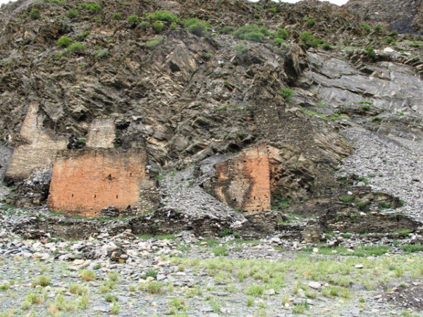
The uppermost complex of Thophu. Note the smaller dark-colored walls of the bon complex.
The uppermost group of carcasses appears to have comprised the largest complex at Thophu. A Buddhist monastery was built right on top of these remains, reflecting the historical succession of the site from archaic religious practitioners to Buddhists. This Sakya sect Buddhist facility may well have been founded during the so-called ‘second diffusion of Buddhism’ (980–1200 CE), but further inquiry is pending. The Buddhist structures are dominated by two hulks with white and red walls towering more than 7 m in height, the vestiges of what appear to have been two adjacent temples. It appears that these temples were built in part with stones extracted from earlier bon structures on the site. Clearly, a symbolic and perhaps overt show of force is implicit in this religious re-appropriation of Thophu.
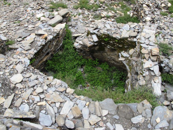
One of the early bon structures in the uppermost complex of Thophu.
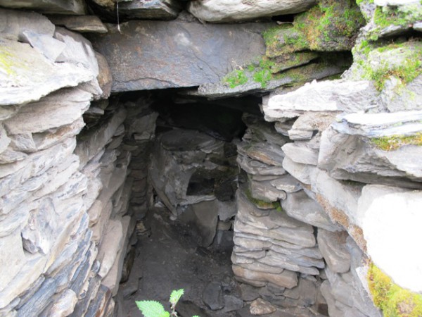
The most intact all-stone corbelled chamber in the uppermost complex of Thophu.
Below the derelict Buddhist temples (they were destroyed long before living memory) are the poorly-preserved remains of the earlier phase of construction in Thophu. These bon structures form a dispersion of all-stone structures that stretches along the base of the formation for more than 100 m. It appears that a large multi-roomed complex split into at least three levels once stood here. The older structures are best preserved on either side of the Buddhist ruins. The heavy wall buttressing, corbels, bridging stones and roofing slabs of all-stone corbelled constructions are found in several structures. The manner in which rear walls are set entirely below the level of the slope and the random-rubble slab wall fabric are also characteristic features of this form of early architecture.
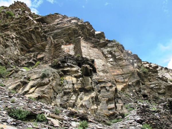
The upper middle complex of Thophu
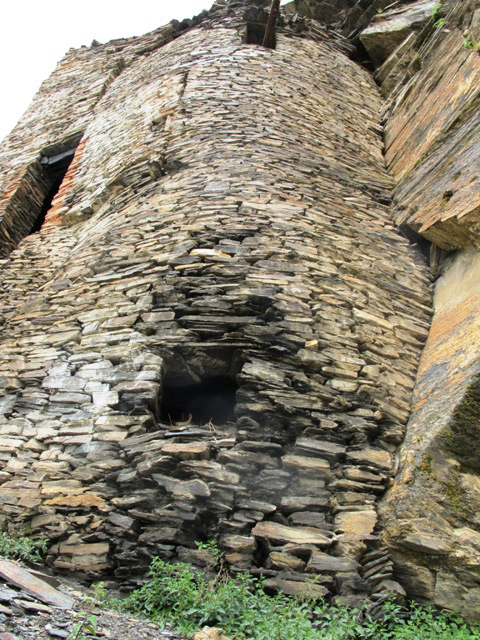
The four-storied all-stone corbelled edifice at Thophu.
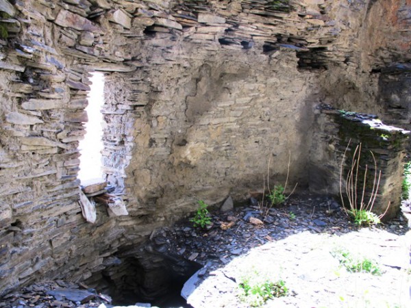
The third level of the four-storied edifice at Thophu.
Approximately 250 m downstream of the uppermost bon residential complexes is a ruined complex dominated by a single building with a lime-tinted front wall some 8 m in height. Below this edifice are extensive revetments that once supported the trail leading up to it. Together, these anterior structures rise more than 15 m, creating an imposing façade. This front is part of a four-storied edifice, the best preserved structure at Thophu. Its relatively good condition is probably attributable to continued use as a retreat center by Sakyapa monks long after the demise of the early bonpo. While almost certainly being founded by the bonpo before the 9th century CE, subsequent Buddhist occupation is preserved in the local collective memory and the two cave shrines in the building are still occasionally visited by supplicants.
The most remarkable feature of the four-storied building at Thophu is its height: nowhere in Upper Tibet have all-stone corbelled structures more than three floors in height been documented. With rare exception, environmental constraints and cultural proclivities conspired to keep ancient buildings in the upland to one or two stories in height. In the Boe (Bod) culture of Central Tibet it appears that there were no such inhibitions and taller buildings may have been quite common (Tibetan historians have traditionally conceived their ancient elite architecture as multi-storied).
The four-storied edifice has a bowed front wall, another typical feature of all-stone corbelled construction. Other walls of this structure are also irregular, so as to accommodate the twists and turns of the corbelled architecture peculiar to Tibet. Some corbels set in the floor of the second level protrude from the exterior of the building as a counterbalance to their load-bearing extensions. Other corbels were used to support a line of rain-guard slabs on the third level.
The fourth or uppermost floor of the four-storied building has been almost entirely destroyed. It contained at least two small rooms. The third floor has a breadth of 10 m and is comprised of four central rooms flanked by two cave chambers. While these rooms have lost their roof, the all-stone roof over the passageway between the third and second level is still intact. There are small two rooms on the second floor. From the second floor another flight of stone stairs leads down to the exterior entrance of the building.
There were all-stone corbelled buildings on either side of the four-storied edifice, as well as two more complexes of the same type of construction situated further downstream. These highly deteriorated structures do not appear to have been reoccupied by the Buddhists. They were left to disintegrate, not even meriting religious emblems such as chortens and inscribed prayer plaques.
Chaktrang
The ancient bon site of Chaktrang is perched on a precipitous conical mount overlooking an extensive agricultural bowl. It consists of a series of all-stone corbelled buildings built into cliffs, many of which are no longer accessible. Rising some 120 m to 180 m above the Mangkhar valley, Chaktrang has an air of social exclusivity but one that must have drew its sustenance from the surrounding agricultural bounty. The establishment of a major residential installation in the heights bespeaks the vigor of its founders and inhabitants. According to the local oral tradition, there were 108 caves (retreat structures) at Chaktrang, and the site is still associated with the ancient bonpo. This long-standing association with ancient religious traditions seems to have minimized Buddhist activity at Chaktrang.
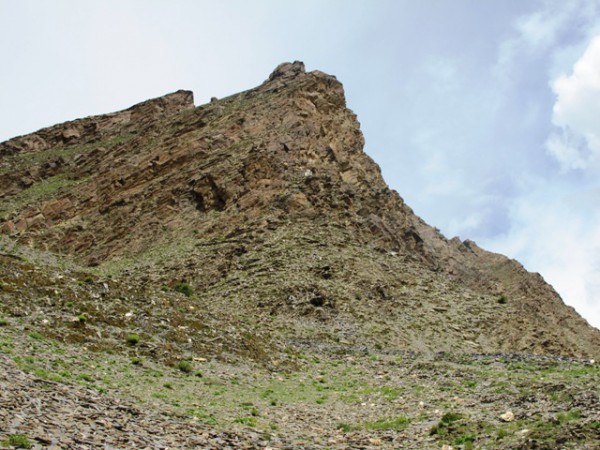
The mount of Chaktrang
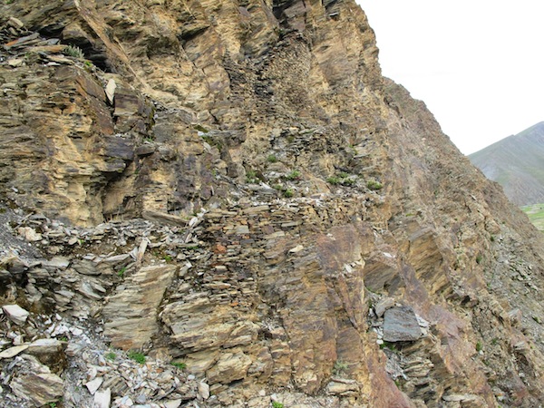
The elaborate buttressed trail that leads up to the cliff shelters of Chaktrang
The ruined all-stone residences of Chaktrang are accessed via an elaborate stone-buttressed trail that winds up the steep slopes. Much of this trail has been destroyed but in certain places it is surprisingly intact. It took considerable manpower and skill to build this elevated pathway and the cliff shelters, reflecting the cultural and religious importance of Chaktrang as attested in Bon literature.
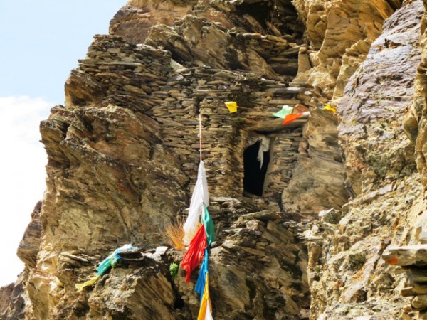
One of the all-stone corbelled edifices of Chaktrang
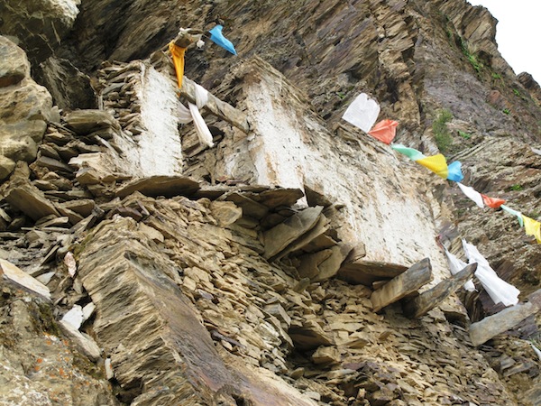
The cliff shelter at Chaktrang redeveloped for use by Buddhist meditators.
On the lower west end of Chaktrang there is a small white ruined chorten, one of a number of ritual instruments used by the Buddhists to wrest control of the site from its bon embrace. The ancient bonpo are likely to have vacated Chaktrang after the state abolition of their religious traditions in the late 8th century CE. The definitive absorption of the site into Buddhist sacred geography and Buddhist ecclesiastical control, however, probably belongs to the post-1000 CE period. On the sheer face of the formation is an all-stone corbelled structure tinted white with lime. Consisting of several rooms erected on top of a high revetment, this particular building was used by Buddhists as a minor retreat center. Prayer flags still hang from its largely intact walls.
In the folk culture of Tibet, the phallus is a protective symbol, while in the Lamaist religions, it is a tantric symbol of the male element of compassion. In ancient Tibet, the nude male figure appears to have had a distinctive but perhaps somewhat related set of functions. It occurs among the class of copper alloy objects known as thokchas (thog lcags), in rock art and engraved on a stone bead (see the four illustrations). The variety of media in which the nude male appears suggests that it held a relatively prominent cultural position in the prehistoric epoch. What specifically this may have been can only be inferred, as written records do not exist in Tibet prior to the 7th century CE.
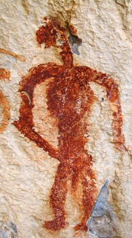
A nude male painted in red ochre, possibly protohistoric period
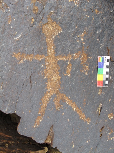
A carved nude male, possibly Iron Age
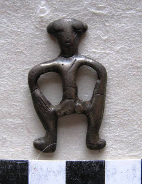
A thokcha depicting an ithyphallic figure, protohistoric period. The male genitalia are now h
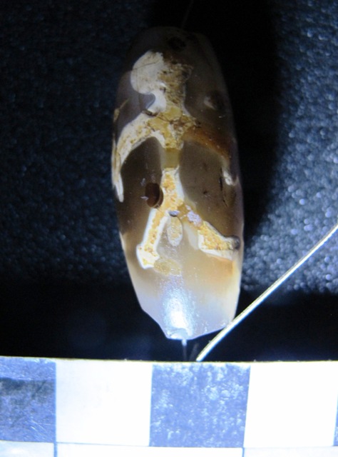
A unique chong (mchong) bead engraved with a nude male figure, protohistoric period. Dawa Gya
Male nudity in rock art and artifacts seems to express fearlessness and mastery. Whether the figures represent mortals or gods, they embody strength, virility and unalloyed confidence. They may have been rendered as fertility instruments, warriors and/or as hunting charms; but in any case, they seem to have been intended to lend power and protection to those who wore or beheld them. Special cult functions are implicit in these depictions, but to comment on what these may have been would be pure speculation.
The engraved agate bead and copper alloy pendant were designed to be worn as talismans in an intimate show of the male form. The red ochre figure stands in close proximity to an animal but it is not clear if they were painted together or separately. To the left of this figure is a Bon mantra inscribed in a lighter ochre shade prior to 1250 CE. The carved naked male is found on a rock panel that also features petroglyphs of horsemen (probably hunters), ungulates and a sun, which belong to the same general timeframe.
Supplement: Buddhist history of Mangkhar
Posted November 2010
Much of the following information was obtained from the well-known Tibetologist Mathew Akester, one of the few individuals to have conducted cultural research in the Mangkhar valley. I heartily thank him for his input. Mathew’s forthcoming book on the monasteries of Central Tibet is eagerly anticipated by many.
The site of Tho-phu in Sa-skya literary sources is known as Cha-lung rdo-rje brag rdzong. Tho-phu is noted as a place where a Sa-skya yogini meditated in the late 11th century CE. There are no indications that any appreciable construction took place in this period. Rather, it appears more likely that the ‘Red’ and ‘White’ temples were built by the Tshar-pa sect who revived the site in the 16th century CE. If so, it would appear that the earlier Buddhist meditators made do with the preexisting bon residences, just as is encountered in the history of rdo-khang situated around Mount Tise. Tho-phu is just on the other side of a small range of mountains from dGe-’phel rdzong, the old seat of power in Mang-mkhar and the birth place of Sa-skya pan-chen. This close proximity helps explain the attention paid to Tho-phu by local Buddhists.
The upper middle complex of Tho-phu is called Shing sgo-ma in Sa-skya sources. It is written that it was used for meditation by rJe-btsun grags-pa rgyal-mtshan (12th or 13th century CE), the son of Sa-chen kun-dga’ snying-po, the founder of much of the doctrinal system of the Sa-skya-pa. This Buddhist master and his fellow religionists would have found the ancient bon complex very convenient for their purposes, affording them shelter in a place of ancient sanctity. Why the complex is referred to as ‘Wooden Portal’ is a mystery, as it is of all-stone corbelled construction. Perhaps a wooden door was fitted on the front entrance of the four-story tall structure as one means of ritually bringing it into the fold of Buddhism, but this is pure conjecture. We can thank the continuing occupation of Shing sgo-ma by Buddhist meditators for its survival. They would have more or less maintained the building preventing it from falling into utter disrepair.
According to a folktale in the Mangkhar valley, it was the wife of King Srong-btsan sgam-po, Princess Wencheng, who helped subdue the bon site of lCags-’phrang. She accomplished this by flying over the mount and dropping some of her menstrual blood on it. Despite this story, lCags-’phrang has never lost its bon associations.
The historian and linguist Dan Martin translated an excerpt from a text that records lCags-’phrang as the venue for a high level summit held in ancient times. Bon-po from Zhang Zhung, Tibet, Gilgit, Central Asia, India, and China are all supposed to have been in attendance. See Martin’s “Unearthing Bon Treasures: Life and Contested Legacy of a Tibetan Scripture Revealer” (Brill: 2001).