
April 2015
John Vincent Bellezza
Welcome to another Flight of the Khyung, a voyage I hope you will find illuminating. This issue is all about the conservation of archaeological sites in Upper Tibet. New threats to the integrity of the region’s history and cultural heritage are faced almost daily.
The article featured in this newsletter began as a lecture delivered at the Conference of Tibet Archaeology, History and Culture held at Sichuan University, in 2011. For a review of the proceedings of this conference see the September and October 2011 issues of Flight of the Khyung. Unfortunately, the papers delivered at the 2011 Sichuan conference were never published. Why this is so, has never been made known to me. To remedy the situation, I have adapted my paper to publication in this newsletter.
Diverting History from Oblivion: A plan to conserve the archaeological heritage of Upper Tibet
An Introduction to Archaeological Conservation Issues in Upper Tibet
For nearly a quarter of a century, I have been documenting the pre-Buddhist archaeological heritage of Upper Tibet, the vast portion of the Tibetan Plateau situated north of the Nyenchen Thanglha Range and west of Central Tibet. This reconnaissance work has been carried as part of efforts to elucidate Iron Age (600–100 BCE), Protohistoric period (100 BCE–650 CE) and Early Historic period (650–1000 CE) civilization in highland Tibet.
Through field surveys of early monumental and artistic remains in Upper Tibet, it has become evident that manmade threats to archaeological sites have grown alarmingly in recent years. These pressures on what remains of Upper Tibet’s ancient material cultural legacy have four major causes: 1) the robbing of tombs in order to recover marketable artifacts, 2) the pilferage of stones for use in domestic building projects, 3) state-sponsored development projects, and 4) vandalism.
The anthropogenic degradation of archaeological sites in Upper Tibet is causing irrevocable damage to the region’s pre-Buddhist and Buddhist cultural heritage. The razing and looting of a variety of ancient monuments subsequent to the Chinese Cultural Revolution has led to the loss of an inestimable amount of scientific data. As a result of this ongoing assault on the archaeological assets of Upper Tibet, the potential for understanding Tibet’s ancient past is steadily being eroded.
This article examines specific threats to archaeological sites in Upper Tibet and calls for the initiation of a project to protect and conserve structural and artistic assets still left intact. Damage to archaeological sites whether intentional or inadvertent is a worldwide occurrence. Commonly, ancient remains are used to create new monuments, in an economic recycling process that can be hundreds or even thousands of years old. Also, for ideological reasons cultural legacies of past eras have been destroyed or rearranged in an attempt to efface or recreate history worldwide.
As is well known, the tombs of the Tibetan kings in Chonggye (’Phyong-rgyas) were looted in the unsettled period after the fall of the Tibetan empire more than one thousand years ago. For just as long, Tibetans have recovered building materials from pre-existing sites to build monasteries and other structures. In certain cases, historically and culturally important edifices have been rebuilt repeatedly. An excellent example of serial refurbishment is the famous Ombu Lagang (’Om-bu gla-sgang), a castle-temple associated with Tibet’s first king, Nyatri Tsenpo (Gnya’-khri btsan-po). Today, it is a Buddhist monastery that probably bears little resemblance to its original pre-Buddhist architectural form.
During the Chinese Cultural Revolution (1966–1976), the Tibetan world lost a vast monumental, artistic and cultural heritage from which it can never hope to fully recover. Many monastic and secular installations were damaged or destroyed during that ten-year long strife-torn period. However, archaeological sites unless they had open religious value were often left untouched during the Chinese Cultural Revolution.
In Upper Tibet, notable pre-Buddhist sites that were harmed in the Chinese Cultural Revolution included the so-called Ombu Zhang Zhung Gonpa (’Om-bu zhang-zhung dgon-pa), an ancient residential complex located on the east shore of Lake Dangra (Dang-ra g.yu-mtsho), in Nyima (Nyi-ma) county. In the late 1960s, during the Chinese Communist collectivization of agriculture, this site was heavily mined for stones to build agricultural terraces. For more on Ombu Zhang Zhung Gonpa, see Antiquities of Zhang Zhung, site no. B-123 (for bibliographic data of print version of this work, see end of this article). For online version, see:
http://www.thlib.org/bellezza/#!book=/bellezza/wb/b1-2-57/
Another important upland pre-Buddhist archaeological site that fared poorly in the Chinese Cultural Revolution was Shang Doring (Shangs rdo-ring) in Zhungpa (Gzhung-pa) township, Gegye (Dge-rgyas) county. The main site consisted of over one dozen sizable pillars (probably funerary in function), which were uprooted during the construction of a new settlement. This cluster of pillars was traditionally protected as a primal sacred site where offerings for the cult of local deities were made. The pillar complex was situated between the administrative compound and the school, neither of which is still standing. For more information on Shang Doring, see Antiquities of Northern Tibet, pp. 166, 167 (for bibliographic data, see end of this article).
One of the most magnificent groups of funerary pillars was found at Namalung Doring (Na-ma lung rdo-ring) in Tshaka (Tshwa-ka) township, Gegye county. It too was heavily impacted during the Chinese Cultural Revolution in a failed agricultural project. Fortunately, the tallest of the thirteen stelae was spared from destruction and still stands, rising 2.3 m above ground level. For more information on Namalung Doring, see Antiquities of Upper Tibet, pp. 112, 113 (for bibliographic data, see end of this article).
Although a few pre-Buddhist archaeological sites, like those described above, were degraded in the Chinese Cultural Revolution, the overwhelming majority of negative impacts have occurred since 1976 and particularly after 1990. In fact, the disturbance of archaeological resources in Upper Tibet is growing ever more severe, the result of a combination of factors associated with modern conditions and policies.
Nevertheless, with concerted efforts on the part of the People’s Republic of China’s administration and citizenry, this trend can be reversed. The PRC has excellent laws governing the protection and preservation of archaeological sites. However, in such a large and developing country, sufficient funds, scholarly expertise and administrative preparedness required to enforce these laws have yet to be fully realized. Nonetheless, as China takes its place in the world of the 21st century this state of affairs should change for the better. In a number of high profile incidents in recent years, the PRC government and private citizens have reclaimed important cultural relics from abroad. Funding for archaeological research and for conversation projects is also being significantly increased. Furthermore, museums are rapidly expanding across the country.
The Causes for the Degradation of Upper Tibetan Archaeological Sites in the Modern Period
As summarized in the introduction to this paper, the degradation of Upper Tibet’s archaeological assets can be attributed to four major causes:
- The excavation of tombs and other types of funerary structures in order to recover artifacts of monetary value.
- The removal of stones from ancient monuments for use in house-building and pastoralist projects.
- State-sponsored development projects such as the construction of new roads, railroads, towns, and airports.
- The vandalism of archaeological monuments by ignorant or malicious persons.
1. The looting of tombs, funerary ritual structures, chortens and other types of archaeological monuments has become a chronic problem in Upper Tibet. Both local people and outsiders appear to be involved in this unfortunate activity. It is alleged by Upper Tibetans that most grave robbing is perpetrated by Chinese Muslims and Khampas from the eastern Tibetan Plateau. Nonetheless, it may be that local individuals sometimes work in concert with thieves by guiding them to sites with potentially valuable artifacts.
Objects with marketable value are removed by robbers for sale on the Chinese art and antiquities markets. Until recently it seems that a large percentage of these ill-gotten gains ended up overseas in museums and private collections. Nowadays, however, a vibrant and growing market for Tibetan antiquities has developed in mainland China, along with the fashion craze for all things Tibetan. This domestic demand is fueling the trade in illicit antiquities.
2. The single largest cause for the destruction of Upper Tibetan archaeological monuments is the pilferage of stones for use in domestic building projects. In the last twenty years there has been a move to resettle the pastoralists (’brog-pa) in permanent housing. This movement from tents to immovable shelters is generally welcome by the pastoralists. In conformance with their wishes, the PRC government has made ample funds available for that purpose. Despite the benefits of this type of development, there is an unintended consequence related to the acute need for economical building materials.
In large swathes of the Changthang (Byang-thang) of Upper Tibet naturally occurring sources of rocks are in short supply. This frequently means that rocks have to be trucked in long distances, significantly increasing the costs of construction. Where stones from archaeological sites are locally available these are increasingly being removed as a cheap alternative to hauling stones from distant locations.
Particularly hard hit are the stone superstructures of graves and other funerary structures, as these are widely dispersed throughout Upper Tibet. The pastoralists are often ignorant of the value of their archaeological heritage and extract stones with impunity for the building of houses, sheds and corrals. The proliferation in truck ownership in the last fifteen years has exacerbated the problem. Stones can now be moved around easily and inexpensively. Another factor contributing to the pilferage of stones is the diminution of traditional cultural sanctions discouraging such actions. Previously, local residents would often avoid damaging or even visiting ancient tombs for fear of being contaminated by the dead or being punished by the protective deities.
3. In a bid to better the lives of local residents and open the region up for demographic expansion and natural resource extraction, the PRC has embarked on an ambitious project of infrastructure development in Upper Tibet. A prime example is the new highway linking western Tibet with the provincial capital, Lhasa. Twenty years ago it could take a week or more to reach western Tibet from Lhasa. Even as recently as five years ago this journey required four or five days of hard travel. Nowadays the same distance can be covered safely in less than three days. Other paved and improved roads are being built all over Upper Tibet.
Due to a lack of safeguards, this road development is undermining or completely destroying archaeological sites. Other archaeological resources have been damaged or obliterated by the construction of towns and garrisons. Even the new Ngari airport in Gar (Sgar) has led to the destruction of an ancient tumulus reportedly containing an elite residential complex known as Spe-mo mkhar. This site is mentioned as an early capital of western Tibet in Tibetan historical literature. From what I can tell, the airport runway cuts right through this archaeological site.
4. The vandalism of ancient pillars has been recorded in several locations. Fortunately, as the Chinese and Tibetans are generally peaceable people, this kind of degradation of archaeological sites is relatively rare. Nevertheless, acts of vandalism appear to be on the rise.
A Preliminary Registry of Pre-Buddhist Archaeological Sites of Upper Tibet Adversely Impacted Since the 1980s
This section of the article provides an inventory of Upper Tibetan pre-Buddhist archaeological sites severely damaged or completely destroyed in recent years. Sites that have undergone only minor damage are not included in this registry. It was compiled as part of my archaeological survey work in northern Tibet (Byang-thang) and western Tibet (Stod), but extends only to 2011.
An estimated 10% of the seven hundred archaeological sites surveyed by me to date have been either wiped out or heavily degraded by human actions in the last thirty-five years. Nonetheless, it is not clear how many archaeological sites in total have been actually wrecked because it has not been possible to resurvey all of them.
Note that all references in this registry are to works published by me unless specifically noted otherwise. Locational data usually include township (or sub-township name) followed by the county name. Sites located in the county seats only carry the name of the county. The alphanumerical site designation (first compiled in 2008) is also recorded. A bibliography of selected works including those referred to in this section of the paper is found at the end of the article.
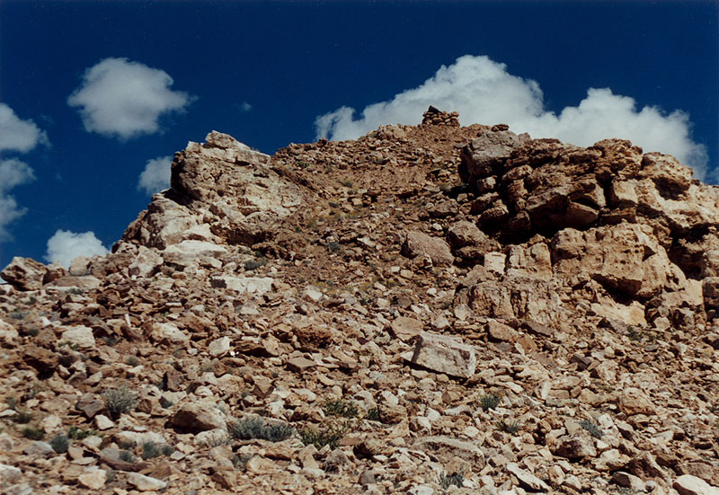
Fig.1. The heavily disturbed ruins of Brag-chag khung-kha, an extensive ancient residential site, mined for stones. Photograph taken in 2001.
Brag-chag khong-kha
- Location: Khyung-lung, Rtsa-mda’
- Survey reference: 2015a, A-55
- Site description: An extensive residential complex located on a rock outcrop in the Yul-smad portion of Khyung-lung village. It was almost certainly established before 1000 CE.
- Anthropogenic impact: In the 2000s, stones were extracted wholesale from the facility in order to build a crude wall around the agricultural landholdings of Yul-smad. This action has had a catastrophic impact on the integrity of the archaeological site.
Gyam-smug mkhar
- Location: Gyam-smug, Sgar
- Survey reference: 2015a, A-68
- Site description: A compact stronghold overlooking the village of Gyam-smug. This ancient facility may have been built in the Early Historic period.
- Anthropogenic impact: Large quantities of stones have been removed from the walls of Gyam-smug mkhar for building projects in the nearby Ngari prefectural headquarters. This pilferage has seriously affected the integrity of the complex, eliminating most evidence of the ground plan.
Stag-la mkhar (Tiger Hill Castle)
- Location: Spu-hreng
- Survey reference: 2015a, A-81
- Site description: Only a few small earthen wall fragments remain from the fortress purportedly established in Zhang Zhung times.
- Anthropogenic impact: Excavations have been carried out at nearby ruined Buddhist installations.
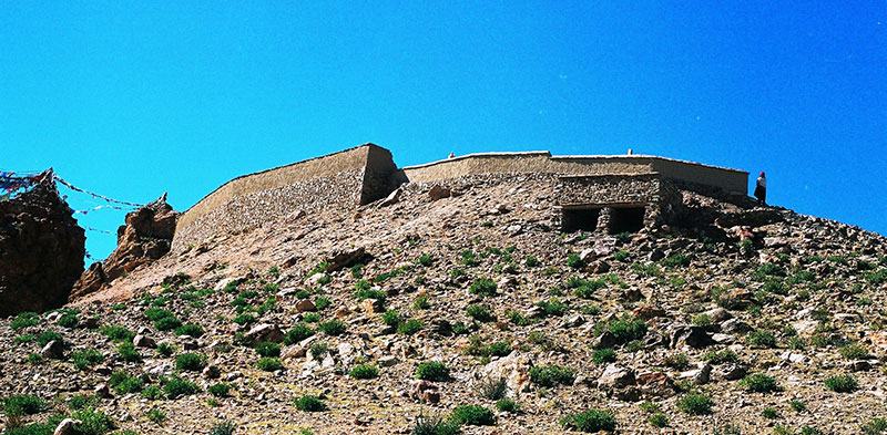
Fig. 2. A new retaining wall and parapet wall at Byi’u-mkhar. This structure has obliterated the remains of ramparts that once belonged to the ancient castle. Photograph taken in 2005.
Byi’u-mkhar (Little Bird Castle)
- Location: Bar-ka, Spu-hreng
- Survey reference: 2015a, A-82
- Description: Locational and typological evidence indicates that this archaic castle was founded in the Iron Age or Protohistoric period. According to Buddhist tradition, the site was appropriated by Guru Rinpoche in the 8th century CE, but this is an apocryphal account of history.
- Anthropogenic impact: As an integral part of the Byi’u monastic complex, stones have for many years been appropriated from Byi’u-mkhar for use in various religious constructions. In 2003, much of the remainder of the ancient castle was dismantled to build a new Buddhist temple on the summit. It is now virtually impossible to assess the original architectonic character of the archaeological site.
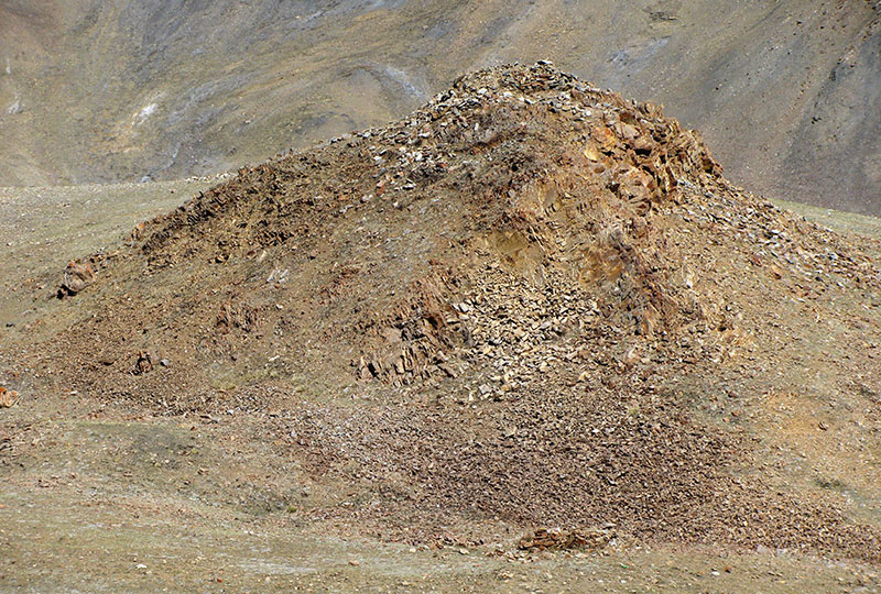
Fig. 3. The main group ruins at the lower Gyang-grags site. This hilltop installation was decimated by the mining of stones. Once there were many standing walls here divided into three building groups. Now there is just rubble. Photograph taken in 2009. For more on the degradation of Gyang-grags, see the July 2009 Flight of the Khyung.
Gyang-grags (Famous Walls)
- Location: Bar-ka, Spu-hreng
- Survey reference: 2002 and 2008, B-9
- Site description: Known as Gyang-grags g.yu-lo ljon in Bon religious literature, this site hosts more than thirty all-stone corbelled edifices dispersed on the southern slopes of Mount Ti-se. The size of the site is congruent with its putative status as the first capital of Zhang Zhung.
- Anthropogenic impact: In the late 2000s, the main group of ruins of the lower Gyang-grags sites was heavily mined for stones, which were used in the reconstruction of Gyang-grags monastery, a ’Bri-gung bka’-brgyud subsect institution.
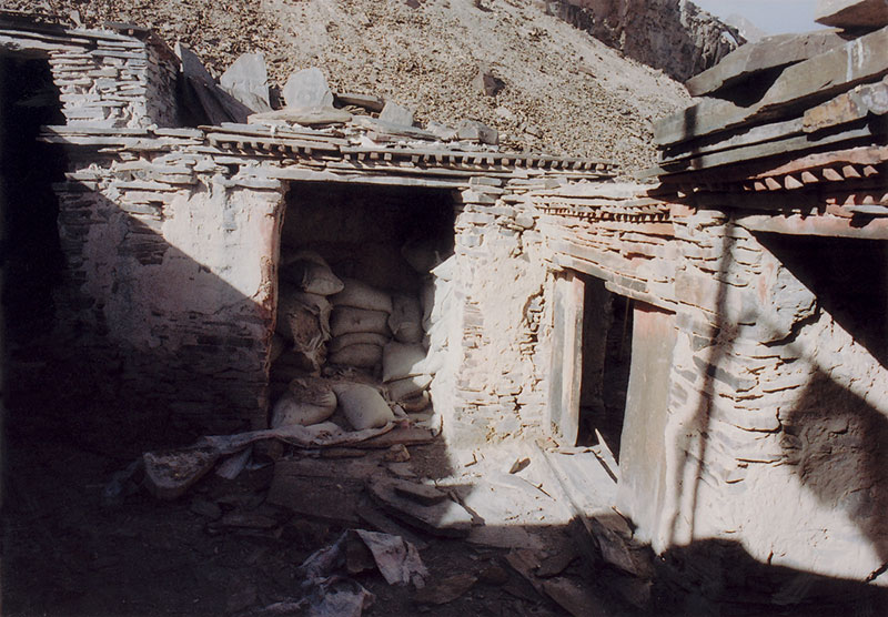
Fig. 4. The use of the all-stone corbelled temple of Ri’u dgon-pa for storage. Note the remaining ripped up paving stones that once lined the courtyards of the temple. Photograph taken in 2006.
Ri’u dgon-pa (Little Mountain Monastery)
- Location: Dung-ru, Ru-thog
- Survey reference: 2015a, B-25
- Site description: An archaeological monument of the utmost historical and cultural value. It remains relatively intact and could be rehabilitated provided proper resources were devoted to this effort. The all-stone corbelled main edifice of Ri’u dgon-pa appears to date to the Early Historic period. It has architectural features of both archaic bon temples (gsas-mkhar /gsas-khang) and Buddhist monasteries (dgon-pa).
- Anthropogenic impact: In recent years, stone members from the roof and floor assemblies have been hauled away in trucks for use at local pastoral camps.
Khog-ra (Open Ground Ruin
- Location: lCags-sgang, Ru thog
- Survey reference: 2002, B-71
- Site description: A zone of rocky pits and small foundation segments blanketing an area of approximately 5000 m². Its geographic situation and the existence of what appears to have been an aqueduct along the Chu-lung watercourse suggest that the ruins of Khog-ra may have been an ancient settlement.
- Anthropogenic impact: The south half of the site has been affected by the construction of a corral. Stones have also been removed from the site by truck, as I witnessed in 2002.
Sa-sna dmar-ri rdo-ring (Variegated Earth Red Mountain Long Stones)
- Location: Bla-brang, ’Brong-pa
- Survey reference: 2015b, C-11
- Description: Consists of fourteen pillars up to 80 cm in height, which are probably funerary ritual in character.
- Anthropogenic impact: About fifteen years ago some of the pillars were vandalized
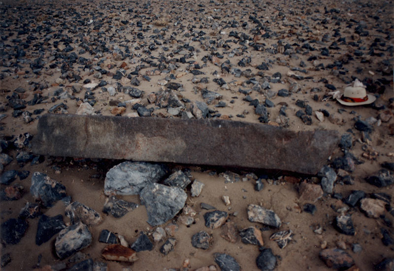
Fig. 5. A dislodged funerary pillar at Lu-ma ar-chung rdo-ring. Photograph taken in 2001.
Lu-ma ar-chung rdo-ring
- Location: Near the right bank of the Indus River in Sgar.
- Survey reference: 2015b, C-16
- Site description: A dislodged funerary ritual pillar and various tombs.
- Anthropogenic impact: A rocky rectangular mound next to the fallen pillar was heavily disturbed by excavation in recent years.
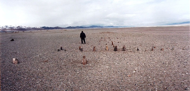
Fig. 6. The Rked-dkar mon-dur site when it was first surveyed in June of 2001. Although the site had already been severely degraded by a road-building crew, some of the standing stones were still in situ. In the background, the almost leveled remains of the temple-tomb can be seen. In 2002, this archaeological site was totally annihilated by road construction workers.
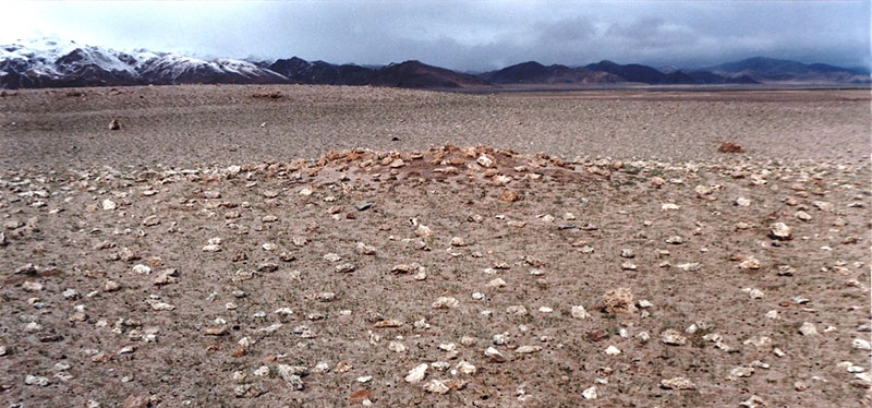
Fig. 7. The faint remains of the temple-tomb at Rked-dkar mon-dur in 2001.
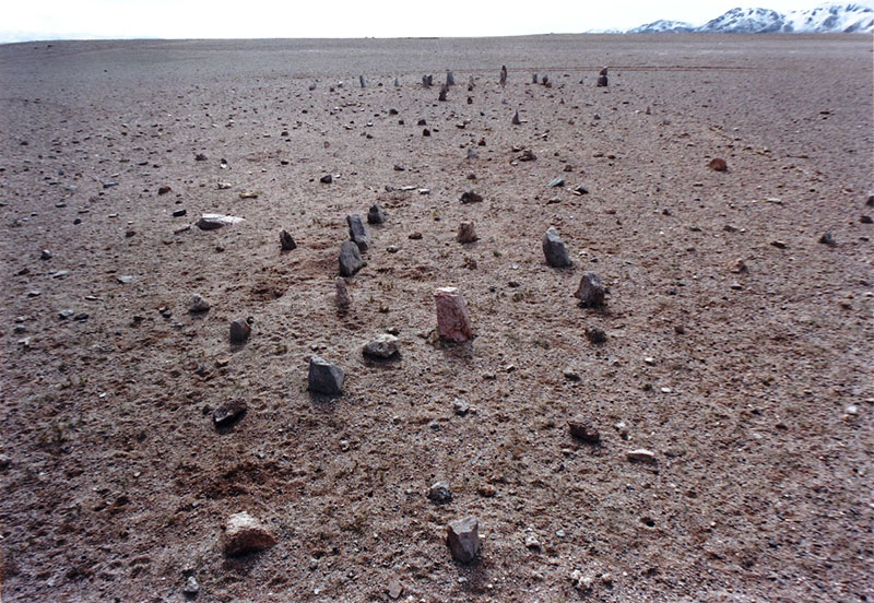
Fig. 8. The degraded pillar array at Rked-dkar mon-dur in 2001. Completely destroyed in 2002, this and other photos by the author are probably the only visual documentation of the site that exists.
Rked-dkar mon-dur (White Base of the Mountain Mon Tombs)
- Location: Tshwa-kha, Dge-rgyas
- Survey reference: 2015b, C-154
- Site description: Comprised of an array of small pillars appended to a temple-tomb, one of the defining types of necropolises in archaic Upper Tibet.
- Anthropogenic impact: By 2001, this rare and highly valuable site had been heavily degraded by construction crews improving the road from Tshwa-kha to the Dge-rgyas county seat. It is reported that explosives were used on the site to dislodge its stone elements. In 2002, it was utterly destroyed by the road building effort, the stones ripped out of the ground to build the new road bed. Clearly, in the wide open stable terrain of the surrounding Tshwa-kha basin, the new road could have been easily diverted around the site.
Sngon-mo rdo-ring (Blue Long-stones)
- Location: ’Ur-stod, Nyi-ma
- Survey reference: 2015b, C-100
- Site description: Boasts a very fine example of pillars enclosed within a quadrate enclosure, one of the most distinctive types of funerary ritual monuments in Upper Tibet.
- Anthropogenic impact: There has been some extraction of stones from the surrounding tomb superstructures.
Rdza-tshogs rdo-ring
- Location: Steng-rtse, Ru-thog
- Survey reference: 2015b, C-28
- Site description: Consists of lines of pillars and associated superficial funerary structures, located on the southern margin of a large marshy basin.
- Anthropogenic impact: The site appears to have been significantly modified by the construction of a corral that is still occupied seasonally. The stones used for it appear to have been extracted from the archaeological monuments.
Lug-rdo mon-dur-khung (Sheep Rock Mon Tombs)
- Location: Khyung-tshang, Nyi-ma
- Survey reference: 2015b, C-172
- Site description: Consists of two main complexes of walled pillars as well as outlying funerary enclosures.
- Anthropogenic impact: Many stones have been extracted from the archaeological monuments in order to build the residential and pastoral structures. Even though local inhabitants believe that this location is an ancient Mon burial ground, it did not deter them from founding a modern settlement here. Provided they receive the proper support, local residents now appear committed to preserving what remains of Lug-rdo mon-dur-khung.
Lo-ro rdo-ring
- Location: Hor-pa, ’Brong-pa
- Survey reference: 2001, C-63
- Site description: Comprised of a single pillar erected inside a stone enclosure, which is located near the confluence of the Rta-mchog gtsang-po and Khug-pa’i gtsang-po rivers.
- Anthropogenic impact: In the last three or four years, the improvement of the main road between ’Brong-pa and southwestern Tibet has negatively affected this monument. Although this ancient funerary ritual site is situated about 10 m from the highway, road crews have wantonly damaged it, threatening its continued existence.
Bal-tshwa gyang-khrog rdo-ring (Wool Salt Ruins Long Stone)
- Location: Ru-skyog, Sa-dga’
- Survey reference: 2015b, C-82
- Site description: Consisted of a single quartzitic sandstone pillar, 1.1 m in height, which was well rooted in the ground. Traces of what appear to have been the north wall of an enclosure were also extant. This wall remnant and nearby mortuary tumuli indicate that this was a funerary ritual site.
- Anthropogenic impact: Despite being located near the edge of the main road running between Sa-dga’ and ’Brong-pa, this pre-Buddhist monument managed to survive until 2010. In that year, the widening and paving of the highway spelled an end to it. Nothing remains. The path of the new road could have been easily altered to avoid destroying the site. many of the nearby funerary tumuli have also been eradicated.
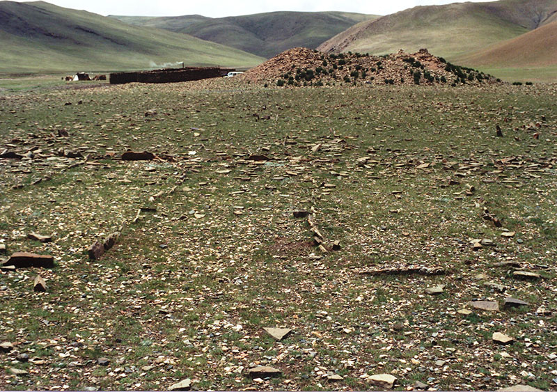
Fig. 9. The remains of the great necropolis at Rkyang-rtswa mdo gyang-ro in 2000. In the foreground are the remains of the concourse of pillars. Behind them is the mortuary temple, now not much more than a rocky tumulus. Reportedly, thirty years ago, the shell of this edifice was largely intact. Rkyang-rtswa mdo gyang-ro was one of the largest and most important examples of an array of pillars appended to a temple-tomb in Upper Tibet. This spectacular archaic cultural complex was of worldwide significance. Its dismantling by local herders in the 1980s was a huge blow to the archaeological wealth of Tibet.
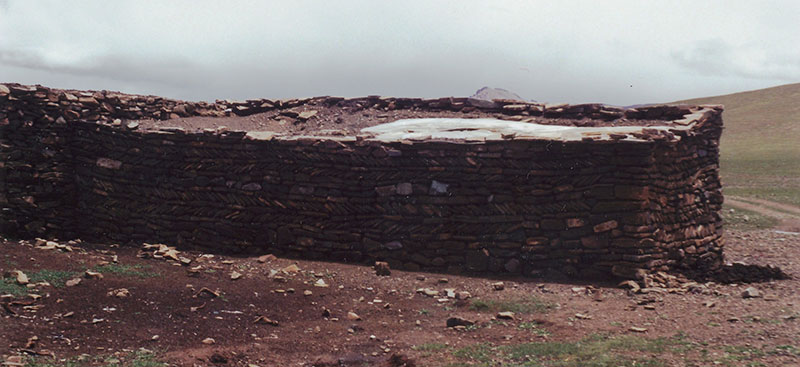
Fig. 10. A large shed built with stones pilfered from Rkyang-rtswa mdo gyang-ro. The diagonal course of stones in the middle of the rear wall mimics the stonework of the mortuary temple. Photograph taken in 2000.
Rkyang-rtswa mdo gyang-ro (Ruins of Onager Grass Confluence)
- Location: Ma-g.yo, Shen-rtsa
- Survey reference: 2002, C-148
- Site description: One of the largest arrays of funerary pillars appended to a temple-tomb in all of Upper Tibet. The concourse of standing stones measured roughly 80 m x 54 m and the mortuary temple approximately 12 m x 18 m.
- Anthropogenic impact: In the 1980s, this extremely important archaeological site was decimated by the local population intent on building corrals and homes. The stones extracted from the site were of sufficient quantity to construct many contemporary structures including a large enclosure for winter pasturage. Many of these pastoral structures have now fallen into disuse.
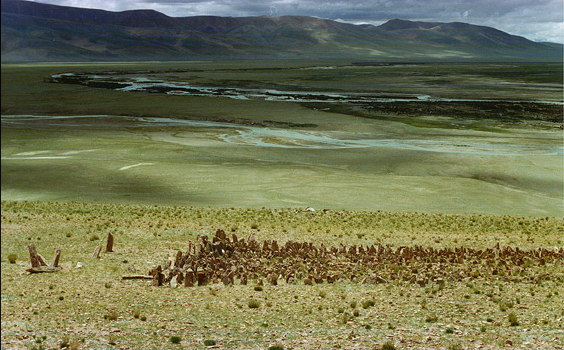
Fig. 11. A view of one of the pillar arrays at Sum-sbug rdo-ring in 1995. According to Dr. Christoph Baumer, who visited the site in the 2000s, many of these menhirs have since been removed from the ground. I only had one occasion to visit this important necropolis.
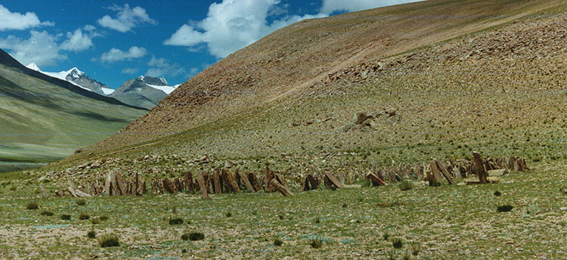
Fig. 12. The other pillar complex at Sum-sbug rdo-ring, 1995.
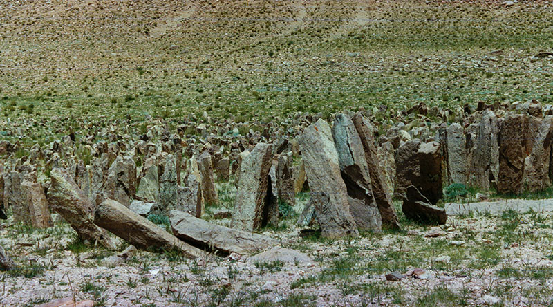
Fig. 13. A close-up view of some of the pillars at Sum-sbug rdo-ring, 1995.
Fig. 14. The piling of dislodged pillars at Sum-sbug rdo-ring, 1995. The film was water damaged in the field.
Fig. 15. The remains of the temple-tomb appended to a concourse of pillars, Sum-sbug rdo-ring, 1995. The film was water damaged in the field.
Sum-sbug rdo-ring (Innermost Juncture Long-stones)
- Location: Nyi-ma, Rta-sgo
- Survey reference 1997, C-147
- Site description: Located near the confluence of the Rta-sgo and Nang-ma rivers are two complexes of pinkish volcanic pillars. Until some years ago, many of the large standing stones were still firmly rooted in the ground. Remnants of the two temple-tombs at this very important funerary site are also visible.
- Anthropogenic impact: Reportedly, in recent years many of the pillars were uprooted and hauled away for local construction projects.
Brag gtsang-po (Rock Formation River)
- Location: Hor, Spu-rang
- Survey reference: 2015b, D-41
- Site description: Composed of no less than sixty sizable rectangular and sub-rectangular funerary enclosures aggregated into at least fifteen main groups, which stretch over a transection of about 1 km along the north bank of the Brag gtsang-po river.
- Anthropogenic impact: Stones are being extracted from the archaeological monuments in order to build corrals.
Brdzi-gdan chung-ba mon-dur
- Location:Rgod-tshang smad, Sgar
- Survey reference: 2015b, D-43
- Site description: Consists of various funerary structures dispersed over a wide area.
- Anthropogenic impact: Stones have been extracted recently from the monuments for use in local building projects.
’Bur-dkar gzhung (White Hill Pasture)
- Location: Seng-smad, Dge-rgyas
- Survey reference: 2015b, D-44
- Site description: There are probably eight or nine quadrate and sub-rectangular funerary superstructures at this location.
- Anthropogenic impact: The extraction of stones from tombs has occurred in order to build various pastoral facilities.
’Byor-khog (Diseased Ruins)
- Location: ’O-ma, Sger-rtse
- Survey reference: 2015b, D-51
- Site description: In a sandy plain just south of the main road running between Sger-rtse and Tshwa-kha are the remains of a number of large single-course quadrate funerary enclosures.
- Anthropogenic impact: Since circa 2000, the site has been decimated by local residents extracting stones for local building projects.
Gnyan-dmar (Red Gnyan)
- Location: Rta-sgoNyi-ma
- Survey Reference: 2015b, D-54
- Site description: A variety of funerary structures including a large burial mound are found here.
- Anthropogenic impact: Extraction of stones from the structures. Reportedly, in the 1980s, stones were removed from funerary structure FS5 in order to build adjacent houses. These houses were later abandoned.
Phyod-ser mon-dur
- Site location: Gro-ba, Nyi-ma
- Survey reference: 2015b, D-55
- Site description: A cluster of superficial funerary structures is located on the flanks of a small hill that rises above a marshy valley bottom.
- Anthropogenic impact: The entire hillside including the funerary superstructures was intensively mined for stones. These stones have been used to construct substantial homes and corrals in the area.
Gyam-nag mon-khang (Black Rock Shelter Mon Houses)
- Site location: Lhag-tshang, Sa-dga’
- Survey reference: 2015b, D-59
- Site description: Comprised of nineteen major funerary structures, most or all of which were used for burial purposes. These tombs are spread out over an area of several hectares. The subsurface architecture consists of well built masonry-lined walls, consisting mostly of large slabs. Massive capstones were placed upon these walls.
- Anthropogenic impact: In the late 1990s, a number of the tombs were opened and emptied by a road crew. The stones were transported several kilometers away to aflood plain and used to build culverts along the main road between Sa-dga’ and ’Brong-pa. In addition to the recent vandalism, there are tombs with highly eroded subsurface members on the surface, which may be evidence of an earlier pilferage of the site.
Byi’u mon-rdo (Little Bird Mon Stones)
- Location: Bar-ka Spu-hreng
- Survey reference: 2015b, D-61
- Site description: Several minor funerary structures are scattered around this site.
- Anthropogenic impact: The funerary structures have been excavated and stones extracted en masse for use as local building materials.
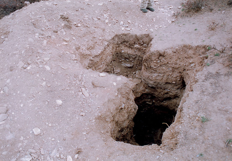
Fig. 16. The illegal excavation of a funerary mound (bang-so) at Rde’u-rug. Photograph taken in 2004.
Rde’u-rug (Hills Side By Side)
- Location: ’Dam-gzhung:
- Survey reference: 2015b, D-99
- Site description: A site with at least twenty-nine large burial mounds located outside the village of Khre-mdo.
- Anthropogenic impact: This archaeological site has been severely impacted by illegal excavations and pilferage. In the Chinese Cultural Revolution, extensive excavations of the tumuli took place, leading to the loss of much scientific data. In recent years excavations have continued. Reportedly, in March of 2004, a group of people from the Chinese mainland unknown to local residents carried out excavations.
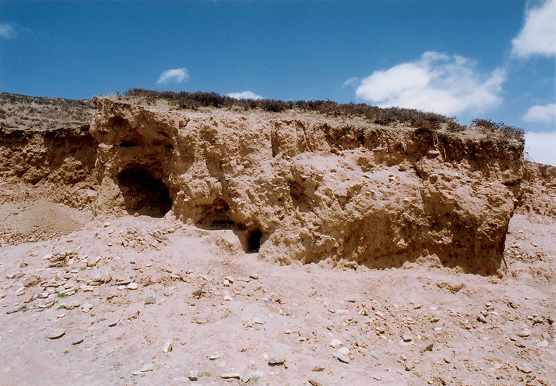
Fig. 17. The excavation of a funerary mound at Chu-mig mdo la-btsas. Photograph taken in 2004.
Chu-mig mdo la-btsas (Springs Confluence Cairn)
- Location: ’Dam-gzhung:
- Survey reference: 2015b, D-103
- Site description: Consists of six large quadrate burial mounds.
- Anthropogenic impact: In recent years, three of the six funerary mounds of the site have been destroyed by looters. The rumored discovery of a ceramic pot containing patterned agates at the site appears to have unleashed a digging frenzy on the part of local residents.
Bde-mchog mon-dur
- Location: Bkra-shis sgang, Sgar
- Survey reference: 2015b, D-112
- Site description: Consists of no less than twenty-five funerary structures of various sizes and types.
- Anthropogenic impact: In recent years, the site was thoroughly looted and most of it destroyed. Some of these funerary structures were excavated in the more distant past. These excavations were almost certainly conducted to recover valuable artifacts. The systematic large-scale nature of the recent excavations can only have been the work of a highly organized and well-equipped team.
Bong-chen (Great Boulder)
- Location: ’Om-bu, Nyi-ma.
- Survey reference: 2001, B-54 (sic ’Phong-chen)
- Site description: On the edge of a steep slope are four complexes of rubble laden tumuli and traces of foundations, which according to the elders of the locale are all that are left of a Zhang Zhung period settlement.
- Anthropogenic impact: The ruins at this site have been mined for local construction projects.
Mon-pa’i dur-khung (Grave Pits of the Mon-pa)
- Location: Rgya-sgog, Nyi-ma
- Survey reference: 2001, D-11
- Site description: Consists of four rectangular funerary enclosures.
- Anthropogenic impact: In the 1990s, stones composing the structures of Mon-pa’i dur-khung were removed in large numbers by truck to build houses and corrals.
Tshwa-kha mon-khang (Tshwa-kha House of the Mon)
- Location: Tshwa-kha, Dge-rgyas
- Survey reference: 2001, D-16
- Site description: Ten small funerary structures were detected here, which are thought by local sources to have been built by the Mon.
- Anthropogenic impact: A couple of small livestock pens at the site were in all probability constructed with stones pilfered from the archaeological monuments.
Mi-lhas ’khor-rdo
- Location: Ra-bang, Ru-thog
- Survey reference: 2001 and 2015b, D-19
- Site description: Mi-lhas ’khor-rdo consists of seven quadrate funerary enclosures, some of which are of significant size.
- Anthropogenic impact: In the 1990s, the funerary structures were dismantled and the stones transported by truck for use in the construction of corrals and other pastoral structures. So heavily pilfered for stones was the site that not one coherent wall remains.
Mon-ra yar-skyed
- Location: Las-stod, Nyi-ma
- Survey reference: Bellezza 2002 and 2008, D-24
- Site description: An ancient cemetery stretching for several kilometers. It contains more than two dozen large superstructures of the heaped wall typology, at least some of which date to the imperial period (630–850 CE).
- Anthropogenic impact: In the 1990s and 2000s, the largest structure of the site, the so-called Rdzong-chen (52 m x 32 m), was excavated to a depth of 1 m in order to supply stones for the development of a nearby pastoral settlement. Corrals, a house and a shrine were also built upon this large burial structure.
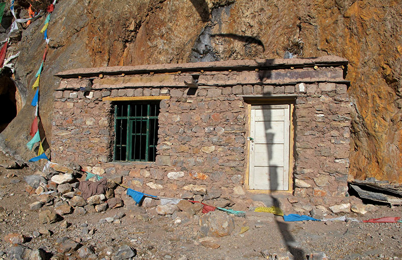
Fig. 18. New house encroaching upon rock paintings situated on the cliff behind it. Photograph taken in 2012.
Bkra-shis do-chung (Auspicious Small Headland)
- Location: Gnam-mtsho, ’Dam-gzhung
- Survey reference: 1997, 2001, 2002, J-1; Suolang Wangdui et al. 1994
- Site description: The single most important pictographic site in all of Tibet. Its various caves harbor red ochre and black pigment rock paintings dating from both the prehistoric era and historic era.
- Anthropogenic impact: In recent years, ancient pictographs have been defaced by the application of butter and by red spray paint. Some pilgrims have used synthetic paint to write mantras, encroaching upon ancient art and in some cases covering it. Residential structures built around some caves have also seriously damaged rock art. The huge local tourism industry has also spoiled some caves.
Lug-ri sna-kha (Sheep Mountain Prow)
- Location: Ru-thog, Ru-thog
- Survey reference: Suolang Wangdui 1994
- Site description: This important prehistoric petroglyphic site is located on the southern edge of the Ru-thog basin.
- Anthropogenic impact: Reportedly, in the mid-2000s, a road construction crew removed large pieces of rock from the cliff face, eradicating most of the petroglyphs. There is plenty of the same stone on proximate rock faces that could have been used by the road builders, obviating the need to destroy the site.
Gri’u chu-thang
- Location: Ru-thog, Ri-gsum
- Survey reference: 2002, J-9
- Survey description: A small petroglyphic site located next to the road linking Ru-thog and the prefectural capital.
- Anthropogenic impact: The site was completely destroyed during the improvement of the road in 2009.
The Recent Destruction of Buddhist sites in Western Tibet
While this paper primarily presents data concerning the anthropogenic degradation of pre-Buddhist archaeological sites in Upper Tibet, extremely serious hazards also exist for Buddhist archaeological and cultural sites. The situation is especially grave in Guge, where in the last few years illegal excavations have reached a fevered pitch. The earthen formations and alluvial depositions of Guge are especially attractive to those who loot ancient sites, for they are relatively easy to excavate. Even more appalling is the increase in attacks on frescos and chortens (mchod-rten), many of which have been utterly destroyed as a result. I shall furnish a few specific examples to illustrate the gravity of the problem.
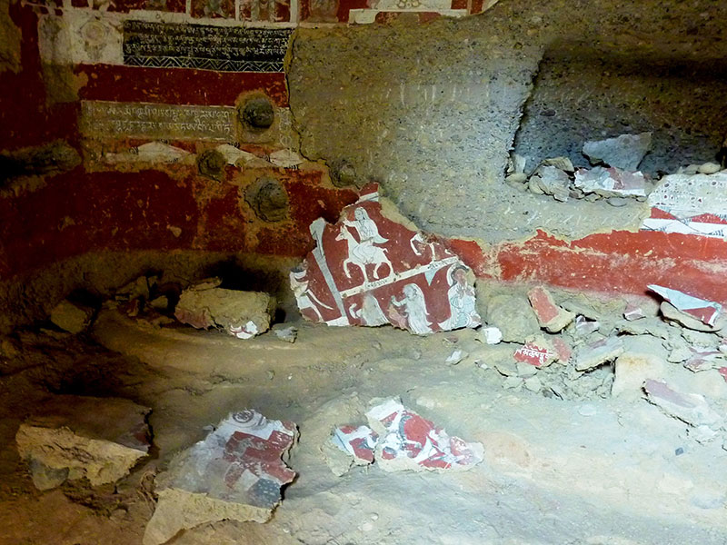
Fig. 19. Destroyed frescos at the Mang-brag cave temple in Guge. This sickening act of vandalism occurred just six or seven years ago. Photo courtesy of D. Ott.
Reportedly, either in 2008 or early 2009, thieves active in removing frescos from the Guge temples came to Mangdrak (Mang-brag). They attempted to pry the paintings off the cave walls but most crumbled to dust when battered in this fashion. Many of the seven or eight hundred-year-old frescoes were annihilated or despoiled in this attack. For more information on Mangdrak, see the January 2015 Flight of the Khyung.
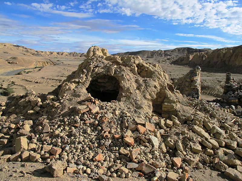
Fig. 20. Some of the mchod-rten broken apart by thieves in 2009 or 2010 at the remote Atsen site, Guge. Photo taken in 2010. For more on the destruction of these religious monuments, see the November 2010 Flight of the Khyung.
Along with government officials and local residents, I visited Atsen (A-tsen) in 2010, a remote location in Shangtse (Shangs-rtse) township. Atsen is the site of a ruined Guge monastery and citadel. The complex of chortens here was smashed by looters. Their contents were either stolen or left to deteriorate in the open. Although these chortens were desecrated in the Chinese Cultural Revolution, their bases and inner chambers had remained relatively intact. Lying scattered on the ground were piles of tsha-tsha (figured clay plaques) and many other damaged objects. A small ceramic jug remained on the surface, miraculously surviving the onslaught of the thieves. Fragments of woolen serge and silk, presumably from the attire of high religious personages were also discarded by the thieves to rot in the elements. At least some of these disgorged objects appear to date to the second diffusion of Buddhism (bstan-pa phyi-dar), circa 1000–1200 CE.
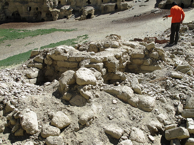
Fig. 21. The bases of mchod-rten destroyed by looters in 2009 or 2010 at Rgya-rang. The individual in the photo is holding a folio discarded by the thieves. Photo taken in 2010. For more on the destruction of these religious monuments, see the November 2010 Flight of the Khyung.
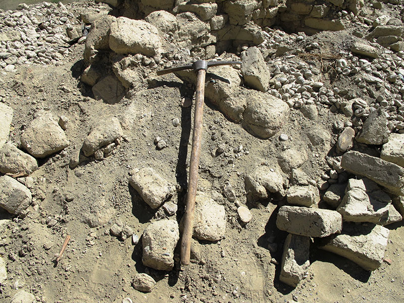
Fig. 22. A pickaxe left behind by thieves at Rgya-rang. Photo taken in 2010.
I also visited Gyarang (Rgya-rang), in Guge, in 2010. The line of chortens at the base of the Gyarang citadel mount was also recently savaged by robbers. Many of the objects discarded by the thieves now lie unprotected on the surface and are quickly disintegrating. Among these disjecta membra are tsha-tsha, the vestiges of what appears to be a small thang-kha painting, Buddhist texts, and woolen serge, etc.
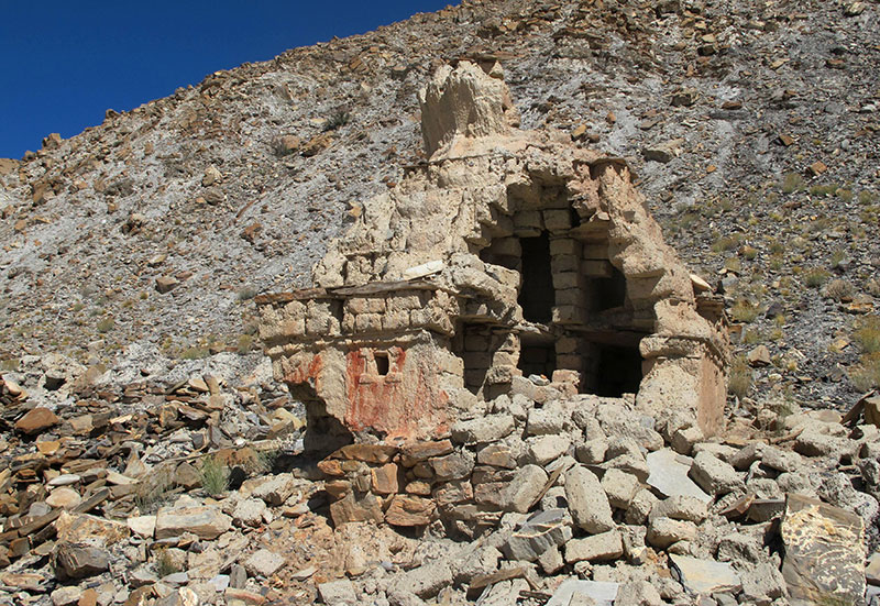
Fig. 23. One of a number of chorten thoroughly opened up and cleaned out by treasure hunters, who apparently were able to work with impunity over a number of days, Dar-skam, 2011.
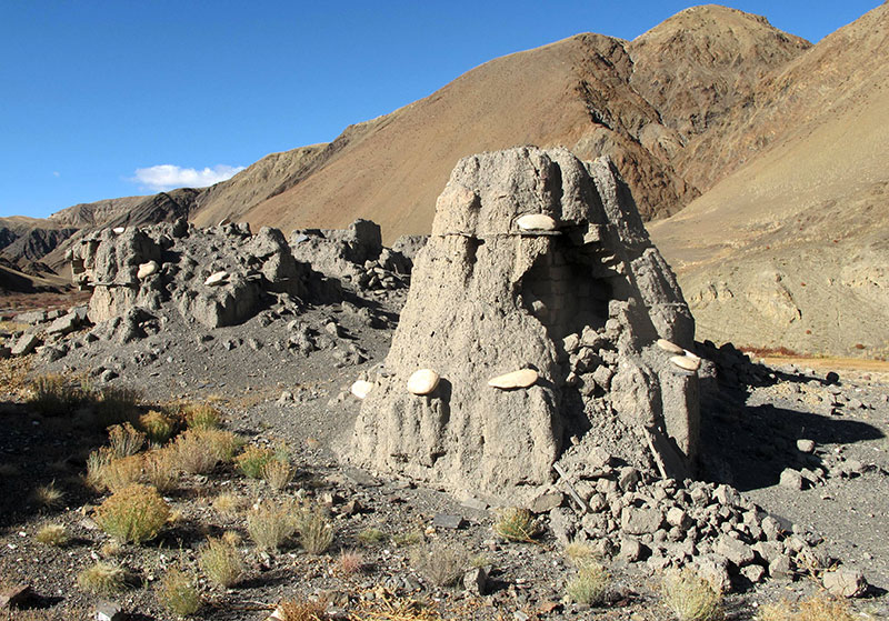
Fig. 24. An illegally excavated chorten in Ha-la, Guge. Photograph taken in 2011.
In 2011, I was able to reach the Guge sites of Hala (Ha-la) and Darkam (Dar-skam), both of which have extensive chorten complexes. Reportedly, at the end of the 2000s, every chorten at these locations was opened and the contents stolen or discarded. These operations required much time and manpower and could only have been carried out through a highly coordinated effort. I have been informed by local government officials and villagers that between 2006 and 2011 most chorten complexes in Guge were attacked and emptied in this same manner. Even the chortens of the famous Khyunglung Yulme (Khyung-lung yul-smad) site have not been spared.
One exception to this disturbing trend in Guge is the village of Dung-dkar. Thanks to the efforts of an alert village headman, thieves breaking into the Dung-dkar chortens were apprehended and handed over to law enforcement officials for prosecution. The violation of approximately 90% of all chorten complexes in Guge in recent few years is a catastrophic loss for the culture of Tibet and the people of the PRC.
The Rudiments of a Conservation Project
Although the PRC and Tibet Autonomous Region (TAR) governments possess excellent legislation regarding the protection of the archaeological and cultural patrimony, laws in themselves are not enough. In order to stem the tide of archaeological destruction in Upper Tibet, an effective conservation plan is required. This plan must be both practical and comprehensive. Experts from China and possibly from abroad working in collaboration should devise and implement a preservation project, one that takes into account the on-the-ground realities of Tibetan culture, geography and economic development.
Securing the physical manifestations of the cultural history of Upper Tibet would have manifold benefits. Firstly, it would permit archaeological exploration and research to proceed unimpeded by the rapid loss of concrete evidence. Secondly, an efficient conservation initiative would have a salubrious effect on Tibetan society by reflecting the Chinese government’s deep concern for the welfare of its peoples. Cultural identity is one of the most intimate and sensitive areas of national life and anything seen as affirming its importance can have much civic profit. Thirdly, well-conceived programs to protect archaeological and cultural wealth (especially that of minority peoples) are viewed favorably in the international community. Diplomatic and public relations gains are likely to accrue to the PRC from such efforts.
A conservation plan must not only be efficient, it must be cost effective and socially acceptable to the resident population. As is well known, many well-intentioned but highly centralized initiatives to protect the archaeological assets of various countries have been impaired or have fully failed. Over the last few decades, it has been consistently shown that conservation projects often breakdown unless civic society is brought into the equation. That is to say, local people and local organizational structures must be a part of any such project and they must directly profit from it.
Those who reside in and around archaeological sites are natural conservators, if only the right inducements, tools and knowledge are offered to them. With this conservation axiom in mind, I propose a multifaceted scheme to safeguard the archaeological heritage of Upper Tibet.
Upper Tibet is a vast and remote region of more than 600,000 km². As long as there are those who believe they can loot archaeological sites with impunity, the problem will not be curbed. Even if an army of law enforcement and conservators were unleashed, it would not be enough to prevent sporadic attacks on archaeological sites. While the full weight of the law is crucial to archaeological conservation, this is but the bluntest of instruments. The successful prosecution of grave robbers may act as a deterrent to potential thieves, but it cannot be the sole basis of a conservation plan.
The most crucial element in reducing criminal incidents is intelligence. The government and all other concerned parties need information about the whereabouts and activities of thieves and their bosses, and this intelligence must be made available effectively and rapidly. The nuts and bolts of any such surveillance network are the people who live and work among archaeological sites. Thus, as regards conservation, it is imperative that special partnerships between administrators, law enforcement personnel and the local communities are forged. This relationship has to be based on mutual trust and respect, and of a nature that elevates the standing of both the PRC and her citizenry.
Nevertheless, much of the damage caused to archaeological sites in Upper Tibet is not a law enforcement issue per se. It is being wrought by local people for utilitarian purposes and not for criminal gain. Thus, in this case, an educational awareness program is called for. Those trained in the conservation of cultural relics must reach out to Upper Tibetans wherever they live with a message tailored to their way of life and cultural sensibilities. It must be explained to them in easily comprehensible language the value of preserving the ancient remains in their midst. The pride that Tibetans evince in their culture and history can be harnessed to convince people of the significance and worthiness of their archaeological heritage.
Ultimately, an efficacious system of conservation management can have many economic spinoffs for local communities and the country at large. Not least of all, archaeological tourism could become a reality, with groups of domestic and international tourists visiting the most spectacular and intriguing sites. It is absolutely imperative that local people be made part of any such tourist industry, with monetary gains going to them as well. This would provide a powerful incentive for them to take care of their ancient cultural wealth.
As an extensive registry of pre-Buddhist archaeological sites exists for Upper Tibet, this region is ideal for a pilot project. As a first step in a comprehensive conservation plan, a high profile initiative could be announced by the PRC and TAR governments. Once Tibetans are made aware that efforts to protect their archaeological sites are being launched, conservation specialists could begin working with the organs of local government. To start with, project teams should visit all fourteen county seats in Upper Tibet, and hold special sessions with county officials explaining to them the goals and benefits of conservation. Tibetan liaison officers could be deployed to smooth communications between personnel at the county and prefectural levels and those at the provincial and national levels.
For any conservation plan to be effective it must be fundamentally decentralized in nature. Therefore, working at the county level alone is insufficient. Teams of conservators in the second stage of a conservation project should visit every township in Upper Tibet, sharing their goals and ideals with officials at this lowest rung of the administration. Eventually, a cadre of township liaison officers could be trained to implement the government’s conservation directives. The lynchpin of the township level program is an effective interface with each village or pastoral camp within its remit. In this way, slowly but surely, the entire population of Upper Tibet would become aware of the government’s commitment to protecting archaeological wealth of all kinds.
On the village and encampment level, responsible individuals ought to be appointed to monitor archaeological sites and to instruct the shepherds and farmers to immediately report any suspicious activities or natural threats to the relevant authorities. Local liaison officers could also ensure that sites are not pilfered for stones. In this manner, the safety net of conversation would spread widely, reaching out from the national and provincial levels down to the community level and vice versa. This outreach must, of course, be benevolent and made in the spirit of mutual cooperation and brotherhood.
It may come to pass that the conservation of archaeological sites in Upper Tibet will have collateral benefits, strengthening the bonds between the government and people in other areas of civic life. At a minimum, a well thought out and implemented conservation project will send out a positive message to individual citizens and to the wider world.
Selected Bibliography of Upper Tibetan Archaeological Sites
Bellezza, J. V. 2015a. Antiquities of Zhang Zhung: A Comprehensive Inventory of Pre-Buddhist Sites on the Tibetan Upland, Residential Monuments, vol. 1. Sarnath: Central University of Tibetan Studies. Online version: Tibetan & Himalayan Library (THlib.org): http://www.thib.org/bellezza, 2011.
____2015b. Antiquities of Zhang Zhung: A Comprehensive Inventory of Pre-Buddhist Sites on the Tibetan Upland, Ceremonial Monuments, vol. 2. Sarnath: Central University of Tibetan Studies.
Online version: Tibetan & Himalayan Library (THlib.org): http://www.thib.org/bellezza, 2011.
____2008. Zhang Zhung: Foundations of Civilization in Tibet. A Historical and Ethnoarchaeological Study of the Monuments, Rock Art, Texts and Oral Tradition of the Ancient Tibetan Upland. Philosophisch-Historische Klasse Denkschriften. vol. 368, Wien: Verlag der Österreichischen Akademie der Wissenschaften.
____2002. Antiquities of Upper Tibet: An Inventory of Pre-Buddhist Archaeological Sites on the High Plateau. Delhi: Adroit.
____2001. Antiquities of Northern Tibet: Archaeological Discoveries on the High Plateau.Delhi: Adroit.
____1997. Divine Dyads: Ancient Civilization in Tibet. Dharamsala: Library of Tibetan Works and Archives.
Bruneau, L. and Bellezza, J. V. 2013. “The Rock Art of Upper Tibet and Ladakh: Inner Asian cultural adaptation, regional differentiation and the ‘Western Tibetan Plateau Style’” in Revue d’etudes tibétaines, vol. 28, pp. 5–161. Paris: CNRS:
http://himalaya.socanth.cam.ac.uk/collections/journals/ret/pdf/ret_28.pdf
Suolang Wangdui (Bsod-Nams dbang-’dus). 1994. Art of Tibetan Rock Paintings. Introduction by Li Yongxian and Huo Wei. Chengdu: Sichuan People’s Publishing House.
Next Month: More Surprises await you!