
June 2011
John Vincent Bellezza
This month’s Flight of the Khyung glides across a big swathe of the Tibetan Plateau in search of the past and the contemporary. We begin with ancient citadels and finish with a trek of 20 years ago, furnishing interesting but different perspectives on the land you all have come to know and love. The eight archaic strongholds featured in this newsletter were first documented between 1995 and 2000. To date, I have surveyed around 140 such ancient citadels in Upper Tibet. More than any other archaeological resource in the region, these attest to the erstwhile political and military might of uppermost Tibet. I hope you also enjoy the account of a walk through Kham as well. So much has changed in Tibet since that time. It is simply staggering.
Insuring the peace, protecting in war: the ancient fortresses of Upper Tibet
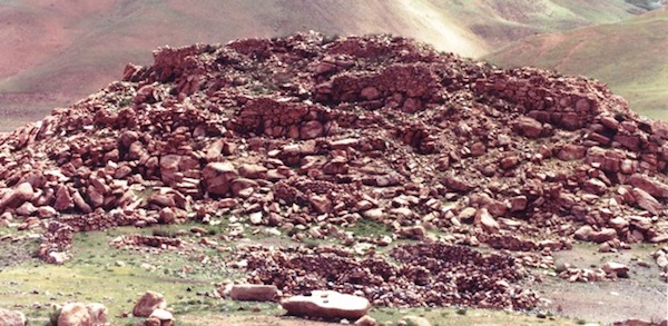
These are the ruins of Gyangpai Tsuk Dzong (rGyang-pa’i gtsug-rdzong, Fortress Walls of the Acme), one of the great citadels of the central Changthang. This ancient installation covered the south and east sides of a hill and the summit too, encompassing an area of approximately 2100 m². According to the local oral tradition, Gyangpai Tsuk Dzong was built in the time of Zhang Zhung. In any case, this archaic era fortress was erected using the all stone corbelled system of construction prevalent in pre-Buddhist Tibet. Corbels and bridging stones are found among the yellow granite rubble. Situated on an old pilgrim’s route, Gyang pai Tsuk Dzong also guarded an agricultural settlement where barley is still being produced today.
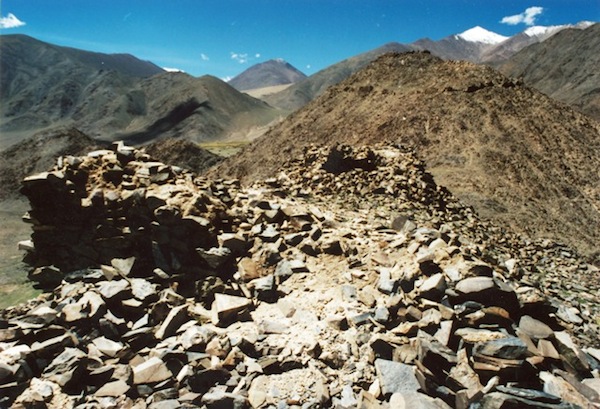
This sprawling ancient stronghold also watches over an old agricultural village in northwestern Tibet, a region rich in early archaeological sites. In the foreground is a portion of the central sector. In the background the circumvallation of the upper or west sector of the castle is visible. This site is now known as the Black Castle on account of the dark colored metamorphic stones used in construction. The Black Castle is thought to have been built by the Mon, one of the ancestral tribes of Upper Tibet. The area below the hilltop fortress is endowed with springs, excellent pastures and a perennial river. However, the once extensive agricultural lands are now only marginally exploited to grow barley. Local residents believe that water for irrigation has been steadily dwindling, explaining the loss of so much of the village’s agricultural base. The central sector contains a dense array of foundations and fragmentary walls and covers an area of approximately 900 m². The upper sector measures approximately 28 m by 28 m and is comprised of a thick concentration of footings and tiny wall fragments. The circumvallation below this installation is roughly 500 m in length.
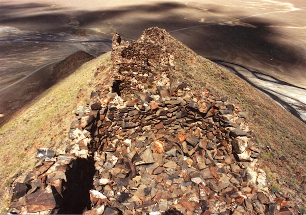
This fortress is located near Black Castle, one of several in the same locale, reflecting its importance in antiquity. In more recent times, the native population has been too small to support even one castle. Climate seems to be the main culprit in the decline of northwestern Tibet. As the region lies in a multiple rain shadow formed by the Himalaya, Karakorum, Kunlun and Pamirs, it is exceptionally dry. Two or three thousand years ago, local glaciers were more extensive, providing ample water for irrigation. What is left of these small sheets of ice may not survive another 50 years if current warming trends continue on the Tibetan Plateau. The absence of outworks and other defensive features at this site indicate that it did not function as a fortress but was rather an alternative type of elite structure (a palace?). The axial plan of the facility (55 m long) is an unusual design feature. Like Black Castle, it is thought to have been constructed by that legendary tribe, the Mon. Nevertheless, it is liable to date to the historic era.
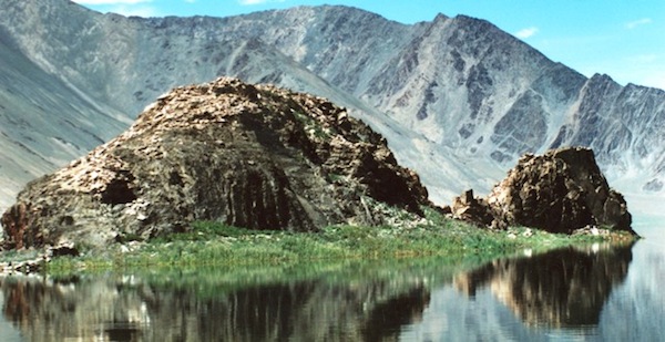
This is one of two insular complexes in northwestern Tibet. The one here is located in a relatively small lake not far from the shoreline, but the hydrological status of the site in ancient times is unclear. In 2000, I reached this islet by swimming out to it, to the amazement of my Tibetan companion. The jagged rocks made getting around tough and the sun reddened my skin but it was worth the effort. Known as Lizard Fortress Division, the rubble of the facility cloaks an area of 85 m by a maximum of 11 m. Not one intact wall segment is still detectable among the dissolving footings. Lizard Fortress Division has geomantic qualities favored by ancient Tibetans: a southern aspect in the middle of a lake-shore overlooking an expanse of water on at least three sides. Possibly such locations were seen as ideal in the worship of lake goddesses, divinities that are still popular in Upper Tibet.
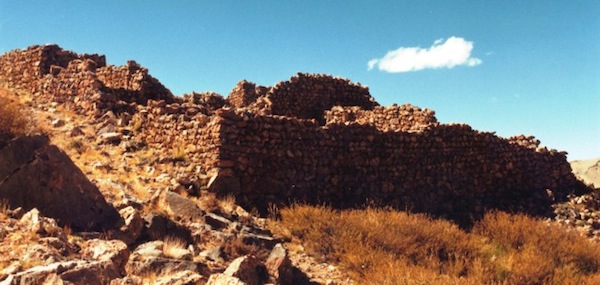
This image shows a portion of one of the three residential complexes perched on top of a 200 m tall rocky mount in the middle of the western Changthang. This installation is not only extremely isolated from the main foci of contemporary settlement, it is situated at 5000 m. Few ancient strongholds in Upper Tibet were built at this elevation. In subsequent Lamaist times major facilities were never founded on such heights. Surprisingly, this was not a rudimentary facility but has every sign of having been a sophisticated hub of ancient settlement. In the image the largest single building (16 m x 22m) of the western complex is shown. Note the coursed-rubble walls, a style of construction that required advanced building and logistical skills, especially in such a difficult environment. This blue limestone edifice was split in multiple tiers and housed a number of commodious rooms. Clearly, this form of construction entailed the use of wooden rafters. In the contemporary period wood suitable for this purpose is not found for hundreds of kilometers around. Perhaps poplar or willow grew in this region in ancient times or possibly its builders were powerful enough to trade long distances for wood? Be that as it may, the Upper Tibetans must have had good reason to raise this highly defensible installation. In addition to insulating its occupants from external threats, the height and inaccessibility of the citadel mount means that it would have been viewed with a good deal of awe. Like many other strongholds in Upper Tibet, this one is attributed to the Mon in the local oral tradition.
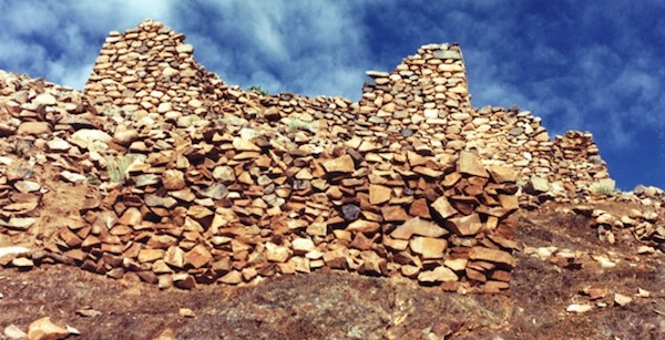
This image is of Khurang Khargok. This is another citadel found in northwestern Tibet, a crossroads of ancient civilization. Some local residents claim that Khurang Khargok was active in the time of the Tibetan emperors, a relatively late period in the annals of civilization in the region. Perhaps the tapering walls of the fortress are indeed an architectural trait adopted from the Central Tibet style of construction. In any case, this is an unusual building feature in the residential constructions of ancient Upper Tibet. Khurang Khargok is one of a number of ancient strongholds that rings the Ruthok basin, the nucleus of settlement in northwestern Tibet in both ancient and modern times. It occupies a strategic position along the southern route into the Ruthok basin. Khurang Khargok is situated on the prow of a ridge behind the south end of Khurang village. It consists of a compact cluster of ruined buildings spread over a transection of 30 m. Nowadays it is the haunts of a territorial god (yul-lha) called Tsenpo Dzara (bTsan-po rdza-ra). This deity appears to be related to the time when Khurang Khargok may have been part of the Tibetan imperium.
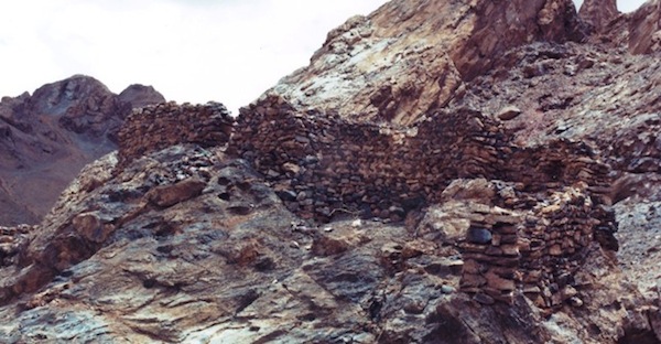
Pictured here is Fish River White Fortress (Nya-chu rDzong-dkar), a derelict ridge-top installation looming over a natural bottleneck in the valley. This is yet another stronghold of northwestern Tibet, once one of the most highly developed cultural provinces of the Tibetan Plateau. To the east is the Indian Subcontinent and to the north is Central Asia, which made this region a vibrant nexus of trade and cultural exchange in ancient times. It appears that Fish River White Fortress underwent various stages of architectural development, the earliest of which goes back to Zhang Zhung times. The older structure (16 m long, up to 2 m tall) pictured in this image is planted on the upper end of the widely diffused site. Lost in time, only a few pastoralists still frequent the valley below and rarely do they visit the castle. Such ruins are considered to be haunted by spirits and personalities of yore, a past few Tibetans still understand.
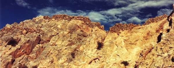
Here we see the ramparts of another Changthang fasthold attributed to the Mon. It stands silent over high volume springs and productive pastures. No doubt these natural endowments contributed to the decision to establish a fortress in this location. This may not have been a large facility but its strategic value was great. Located high up in the crags, even a relatively small band of defenders could protect the locale from unwanted intrusion.
A Retrospective: Crossing between two provinces of the Tibetan cultural entity
Journal entry of July 10, 1991
While lying in my sleeping bag this morning I mulled over the idea of remaining put for the day. I eventually decided against it because of limited food and fuel supplies. I made preparations to leave in a casual manner. I had no intention to push myself hard today. For several miles the trail followed an alpine basin. At the end of the basin where its drainage turns to the east, the trail climbed into a side valley and towards a pass. The ascent to the pass on the derelict motor road was gradual. On its west side, the Mo la (the name of the pass I was to learn later) drops off dramatically to the Chashu valley. I descended many hundreds of meters into an agricultural pocket and followed a narrow gully through barely fields, wondering where the village was. In the driving rain I found it on a steep slope (to conserve arable land). I inquired about the trail with a young man who invited me to his home for food. I was given greens and tsampa as a village mob examined me. These greens were much appreciated. These were the first fresh vegetables I’ve eaten in quantity since Labrang. I rewarded my Good Samaritan with the knife purchased in Labrang. I thought this would be a good example to others as to the benefits of hospitality.
When leaving Chana village the sun was out. I walked down the constricted outlet of the mountain cove to the Shu Chu (Ngom Chu on my map), a main feeder of the Mekong. I crossed the river on a well made pedestrian suspension bridge. I then climbed up several hundred feet to Chazangu Gompa. As I arrived it seemed that every man, woman and child came out to meet me. In no time at all I had attracted a crowd of monks and lay people. I tried to be casual but the mass of people would not disperse. I made a circuit of the main temple accompanied by a couple score of young monks. A few minutes of respite came when a Khampa businessman invited me onto his rented verandah. Back at the monastery, a few monks saw to finding me a place to sleep. I settled for a partially enclosed space one level up from the ground. I erected the inner part of my tent next to the murals of symbolic interdependence and the three-fold elements of enlightenment. I was accosted by a horde of young monks while trying to rest. They touched and fiddled with my tent and stared intently at the strange figure before them. Hands where everywhere. I was afraid that the tent would not hold up. For about an hour, until being summoned by the abbot, I had to endure being an exotic zoo animal on display. The 62 year old abbot has his room on the uppermost level of the main structure of the monastery several floors above my humble tent. We talked for an hour or two about Tibetan geography and history. I was given tsampa, curd, tea, and meat to eat.
The abbot impressed me as a kindly soul with an ever ready capacity to laugh. He is the perfect grandfather figure for the young monks. During the excesses of the Chinese Cultural Revolution Chazangu was closed and the monks discharged. Now religious practice is tolerated. The bespectacled abbot has a Geshe degree from Chamdo. There are 200 mostly young monk inmates at Chazangu. A basic Tibetan ecclesiastic curriculum up to the ninth level is available. However advanced tantric and dialectic training is lacking. The abbot is the only Geshe which in itself says reams about the status of education at Chazangu. The monastery was founded by Nawang Lobsang Tenzin Gyamtso (Changu Rinpoche). The two luminaries of Chazangu are the venerable Nawang Jinpa (abbot) and Lama Tawa Jigme Kapsang.
Until dark I was reluctantly the object of interest for a steady stream of curiosity seekers. Night and solitude came none too soon for tired me. Adjacent to the Gonpa is the village of Sankha which reportedly contains 40 homes. Tomorrow a delegation of monks from Chamdo is supposed to arrive. I might be able to get a ride out to Riwoche the following day. I hope that the intensity of interest in me subsides. I find the attention excessive. Hundreds of groping hands and focused eyes are a bit much especially after a long day of hiking. I must add that the people are friendly and there is not a trace of malice or artifice in them. They are certainly rough on the outside but have good hearts. What a contrast to the people with suave exteriors and hearts of stone you encounter in the sophisticated world. I believe I am the first caucasian visitor or in God knows how many years. My tent and I are truly from another world. This valley is not well forested like the one between the last two passes. Essentially, it is a no man’s land straddling two provinces. I had to traverse two big and two smaller passes to make the interprovincial connection. I estimate I walked 45 hard miles between Chemshi and Chazangu. From hereon in there is no turning back in the administrative sense. Welcome to a remote niche on the Roof of the World. My own curiosity is not unlike my neighbors. I am also impelled on to experience new sights and spectacles. The quest moves forward in the heart of the mind and the country. There on the wall: Om ma ni padme hum.