
July 2011
John Vincent Bellezza
The Flight of the Khyung returns to the great lakes of the western Changthang to explore traces of ancient civilization uncovered in 1997 and 1998. As majestic and beautiful as these lakes are how can one resist returning? The years 1997 and 1998 were still the early period of discovery. I did not possess much knowledge about what was being uncovered. It would take many more years to make sense of Upper Tibet’s vast pre-Buddhist cultural heritage. This look at the ancient residential architecture of the headlands and shores of two famous lakes is benefited by my subsequent research and exploration. Yet, much remains to be done. Most of the photos featured in this newsletter have never before been published. I hope you enjoy this look back through the ages. As always, if you have any questions or comments, please do not hesitate to contact me. I shall always respond to emails that arrive in my inbox: jbellezza@hotmail.com

Fig. 1. Looking towards the shoreline from a small prominence called Headland of the Rock Shelters.
This erstwhile island shown above connected to the mainland by a thin gravel spit. In ancient times, when the water levels in this lake were higher, this location would have only been accessible by boat or in the winter over the ice. There are some fairly high mountains in the drainage basin to the south, so with the pronounced melting of the glaciers that is underway, there is a chance that in the years to come this headland will resort to being an island again. The object in the middle of the spit is only a rock outcrop.
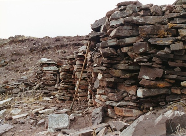
Fig. 2. On the same rocky headland are ruins of all stone corbelled residences (dokhang / rdo-khang), which date prior to the introduction of Buddhism.
The precise date of construction of the above residences is not known, but this insular settlement is likely to date to the protohistoric period (100 BCE–600 CE) or perhaps even somewhat earlier. In any case, radiometric analysis of organic samples taken from analogous structures indicates that this style of architecture arose in Upper Tibet no later than 500–100 BCE. In the local oral tradition, these ruins are associated with the ancient bon-po. In fact, for local residents, the entire lake still has a very strong bon aura. Very few people live along the lake for fear of negative influences associated with ancient bon. Such fears, as irrational as they may be, are still deeply rooted in the region. That the archaeological sites of this lake were indeed occupied by practitioners of bon is evidenced in the red ochre counterclockwise swastikas and later epigraphy sprinkled around its shores. Bon here can be defined as archaic or pre-Buddhist Tibetan ritual traditions and their sacerdotal functionaries, and should not be equated with the later Lamaist religion. That said, there are many historical links between them and Eternal Bon sees itself as part of the same unbroken religious heritage. In the one thousand-year old Eternal Bon religion, the lake we are visiting is considered sacred. It is reputedly endowed with a name that in part comes from the Zhang Zhung language: Dayar Semen Godema (Da-yar se-sman go-de-ma).
Headland of the Rock Shelters is not a large archaeological site. It consists of just four minor residential complexes. Pictured here is the largest and most intact example, which consisted of four small interconnected windowless rooms. This 9 m long structure was built into the base of the headland and nearly all the rear wall is situated below ground level, giving it a semi-subterranean aspect. Like the other three complexes of the site, this structure faces east and is surrounded by the lake on three sides. This edifice is the only one discovered on the lake with its roof largely intact, furnishing important information about ancient building techniques.
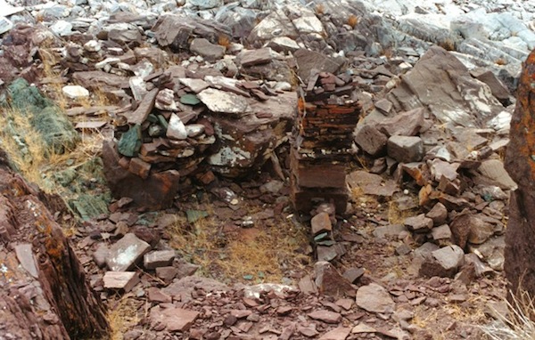
Fig. 3. Near the tip of Headland of the Rock Shelters is the smallest of the residential complexes.
Very little of the residential complex pictured above survives. This structure built of sandstone (like others at the site) appears to have had only a single room. Although only fragmentary wall footings remain, it is evident that this was a robust building constructed with stones up to 1 m in length. The stone column in the middle of the structure is not a fully original feature. Its base however may be part of an original wall partition. A crude stone shed was constructed on one side of the ruin. In it the mani mantra has been scrawled, part of the tenuous hold that Buddhism has over this area.
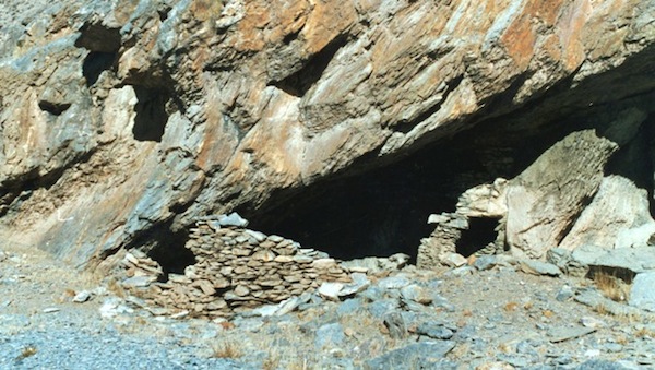
Fig. 4. The shoreline of the lake has a long string of caves found at the foot of escarpments.
According to Eternal Bon literature, two cave complexes here are associated with Zhang Zhung masters of yore; including the fabled 8th century CE figure Nangsher Loepo (Snang-bzher lod-po). However, by the time this saint reached the lake, it was very late in the annals of early civilization. The zenith of this civilization is in question. Given the chronometric and cultural evidence at hand from Upper Tibet, this seems to have occurred prior to 300 CE. In the picture are the vestiges of a stone façade enclosing a spacious cave. At one time many hundreds of people must have lived along the shoreline. In early historic times (650–1000 CE), such troglodytic settlements appear to have been mainly the province of anchorites. In earlier times, however, we might speculate that the lakeside caves accommodated a larger cross-section of the local population.
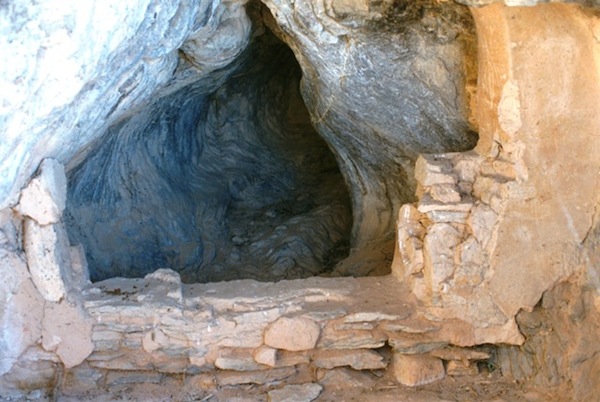
Fig. 5. The walled off rear chamber of a cave. As this wall is sheltered inside a cave, much of the plaster covering it is still intact.
We might expect that many of the more exposed bare stone walls of the lake sites were also covered in a mud or clay veneer. The rear chamber of this cave does not appear to have been used for domestic activities. It may therefore have functioned as a shrine or sanctum. In historic era Upper Tibet, some caves lying behind monasteries were also selected for such purposes.
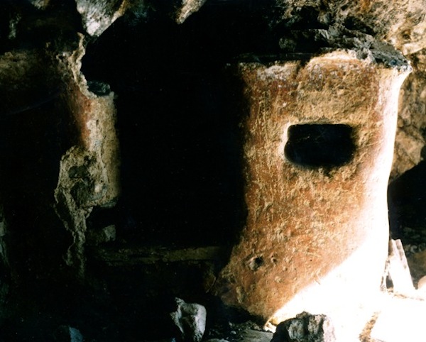
Fig. 6. This stone and mud construction appears to be the remains of a shrine or less plausibly, a storage bay. It too is found inside a cave, explaining its survival.
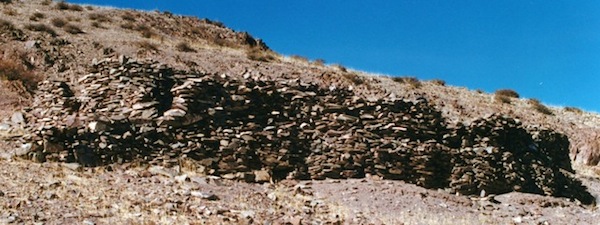
Fig. 7. This is the largest all stone corbelled residential structure on the lake. It is also found on a headland but this large red topographic feature has always been connected to the mainland.
The multi-roomed structure shown above is 18 m in length and 8 m in width. The walls of the structure reach a maximum height of 4 m. Originally, this building was somewhat taller. It is one of no less than six such structures established on the headland.
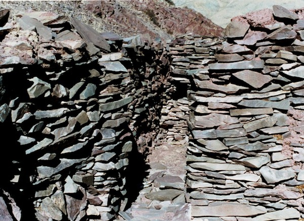
Fig. 8. The interior of the same structure.
Although the walls above are bereft of their roof and have had to withstand earthquakes, subsidence and other disintegrating forces, the high quality of the stonework is apparent. Of dry-wall construction, time has proven its worthiness.
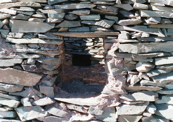
Fig. 9. A small entranceway and niche in the walls of the same edifice.
These apertures of the above entranceway are supported by stone lintels. Vestiges of the mud plaster that enrobed the walls are still visible. In this kind of construction stone was used for the entire shell of the structure. Precious wood was reserved for other applications such as the fabrication of tools, weapons and household implements. As for drinking, the lake still yields pristine sweet water, one of the few major Changthang lakes to still do so.
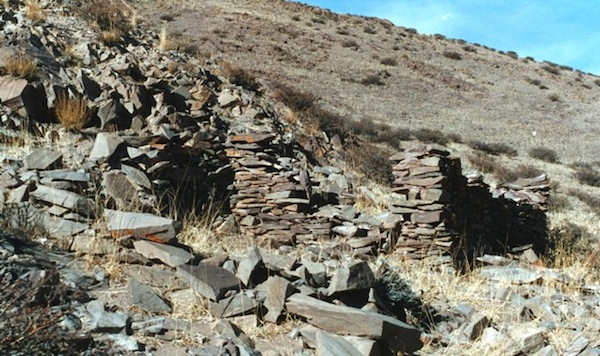
Fig. 10. One of the other all stone corbelled buildings on the same headland.
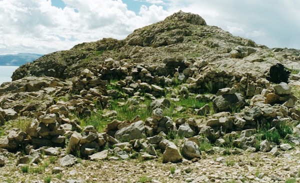
Fig. 11. This all stone corbelled edifice is located on the other Changthang lake featured in this newsletter.
The small headland pictured here only supported a single building. No doubt it was built and occupied by an elite social group of the region. All products and services needed for the upkeep of the residents had to come from the mainland. Behind the structure is the rocky spine of the headland. On the right wall of the structure is my trusty backpack. To reach this erstwhile island I had to traverse several kilometers of alkaline flats pockmarked with quicksand. This is not a destination for armchair archaeologists!
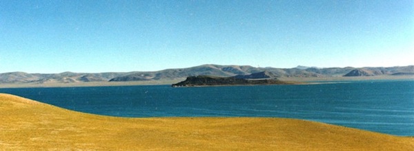
Fig. 12. The big black headland of the same lake seen from the south.
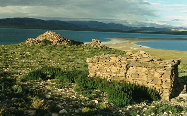
Fig. 13. This headland is connected to a spit 5 km in length.
In ancient times, when this lake was about 2 m higher, the big black headland was an island. This island was around 2 km in length and supported 13 all stone corbelled residences, including one of very large dimensions. Many dozens of people must have once called this island home. In this image we see the remains of shrines set near the shore of the lake. The twin cubic structures in the foreground appear to be of the tenkhar (rten-mkhar) type, which are used in the worship of native divinities. We might conjecture that these particular examples were given over to the propitiation of the local lake goddess. Her name, Tredei Tshomen Thingkhama (Kre-de’i mtsho-sman thing-kha-ma), has been preserved in Eternal Bon ritual texts. The first part of her appellation belongs to the Zhang Zhung language.
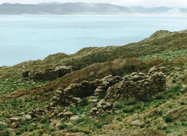
Fig. 14. Two of the corbelled residences set on the rocky backbone of the big black headland.
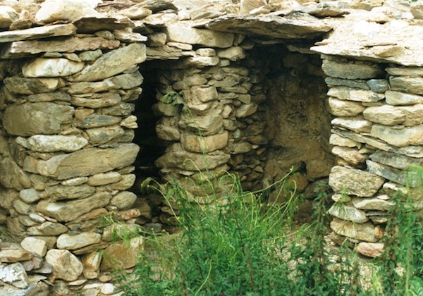
Fig. 15. The interior of one of the residences.
Note the in situ corbels, bridging stone and lintel in the picture above. The alcove in the middle of the picture is a common feature of all stone corbelled architecture. The walls around these alcoves help to support the heavy all stone roofs more generally.
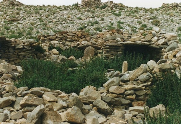
Fig. 16. A partial view of the largest building on the big black headland. Note the in situ corbels and sheathing.
Measuring 50 m x 10 m, the building above was clearly a very formidable structure (or series of structures), requiring considerable manpower to establish and maintain. This may have been a sekhar (gsas-mkhar), the temple of pre-Buddhist Tibet. It may have also functioned as the prime domicile of the island or alternatively as a communal residence. The impressive ruins of the big black headland represent the remains of a large insular cultural center, which was certainly founded before the early historic period. A pillar enshrined inside one of the residences has been compared by the American archaeologist Mark Aldenderfer to a structure unearthed in Guge and dated to circa 400 BCE. This suggests that the big black headland settlement may have been founded as much as 1000 years before the early historic period. Perhaps in that time the lake waters were still potable. Today they are saline and unfit for most uses. Such a large settlement needed a significant and reliable source of water and it is hard to see where this could have come from, if not from the lake itself. The rocky headlands and islands of the great lakes do not harbor springs of any significance. While localized sources of waters may have been more prolific in ancient times, it is difficult to see how these could have ever supported big population concentrations. Perhaps that is one reason why the big black headland has so many ruined shrines. Its residents may have been attempting to forestall the salification of the lake through ritual means. Those shrines facing east and southeast in particular may have been designed to attract monsoonal weather systems from the Subcontinent. Whatever, the details of its cultural history, at some point in time the lake became too salty to drink. If not already abandoned by that time, this would have most certainly spelled the extinction of the community. Very few local herders have ever visited the big black headland. It has been consigned to history, a glorious history at that, but one that is only now being rediscovered.
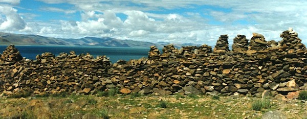
Fig. 17. Among the many ruined shrines of the big black headland is one consisting of a meandering masonry base 34 m in length surmounted by a series of pyramidal structures.
The structure shown here marks the western bounds of the ancient settlement. If this is a type of chorten (mchod-rten) topped by a series of bumpa (a bulbous structure), we might expect that it dates to the early historic period. This identification however is not at all certain. Instead, we may be looking here at a precursor to the chorten. We can assume that this raw stone structure was once well formed and encased in plaster, and bright mineral pigments may have enlivened its veneer. Whatever, its precise identity, this rare ceremonial structure is an important piece of the ancient cultural heritage of Upper Tibet. I have documented similar structures with two or three bumpa belonging to the bonpo, but never one as large and elaborate as this.
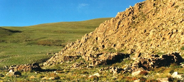
Fig. 18. Near the shore of the same lake is another ancient settlement consisting of all-stone corbelled residences or dokhang. In this image we see four of the structures of Red House (Rdo-dmar).
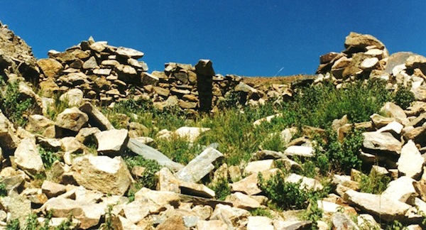
Fig. 19. Another ruined dokhang of the Red House site. Note the lone corbel suspended over the rear wall.
From my journals
November 11, 1997 (exploration of the first lake featured above):
My neighbors, the men from Ruthor, were on the road long before me, as I had three days of journal entries to catch up on. Although we were camped right next to each other, they afforded me the highest degree of privacy and this morning wished me well on my journey. This lake is another of the Changthang’s fabulous bodies of water. Like the lakes of the Dyads (Mapang Yumtsho, Dangra Yumtsho and Nam Tsho), it is radiantly dynamic befitting a ‘divine lake’ (lhatsho/lha-mtsho). After breaking camp, I walked the remainder of the western lakeshore scanning the adjoining ridges and vales for any signs of cultural sites but with no success. My binoculars could find no sacred sites… From the largest of three houses a man emerged to meet me and invite me inside for tea. I was to hear extraordinary things about the region from him. He told me that since rounding the north shore I had entered a precinct of special religious and historic interest. He said that to the east, in the escarpments and headlands abutting the lake, there are numerous sacred caves including ones with paintings. He described seeing a swastika but was short on details. He said that in the vicinity were the remains of ancient domiciles, and his mother added (from her bed on the floor indicating that she is living her last days) that these structures were part of extensive settlements of the ancient bon-po. She also thought that agriculture was once practiced in the region…
August 27, 1998 (exploration of the second lake featured above):
My neighbor left very early this morning as I lay in my tent. The weather is much better these past few days with only light showers during the day. The morning sunlight streamed into my tent making for a very pleasant environment in which to break camp… I was 12 minutes into the morning walk when I remembered that I had left my cup with tea still in it at camp. I had put it aside so as not to upset the tea and had forgotten to repack it. Using a pile of bones and a puddle as landmarks, I found my cup in the midst of a sweeping plain. My first objective today was to reach the Darong Tsangpo, a small river draining into the lake. My map misled me into believing that I would cross it several miles west of Muro Ri, when in fact it debouches into the lake just 2 km from the western edge of Muro Ri. I took my lunch stop on the bank of the river, which is running strong thanks to the summer rains. I also washed socks and filled both of my water containers giving me a capacity of eight liters. The next reliable source of water is at a place called Mertshik nearly a day’s walk to the east. I am not going straight through however and may need at least a day to explore Muro Ri. I walked from the river to the base of Muro Ri and made camp overlooking the lake…