
June 2014
John Vincent Bellezza
Welcome to these pages! Flight of the Khyung takes in the ancient wonders of highest-most Tibet. Read on to learn about the secrets of one of Upper Tibet’s greatest island sanctuaries. This month we also visit an epic, pre-Buddhist ceremonial center.
A new book
My new book, The Dawn of Tibet: The Ancient Civilization on the Roof of the World, is due to be published in August. This overview of three decades of my research and exploration, along with new insights and findings, is written for both the academic and the general reader thirsting to know more about ancient civilization in Tibet. For a synopsis of the book, photograph of the cover, and ordering information, please see: https://rowman.com/ISBN/9781442234628
A nexus of ancient Upper Tibetan settlement: Revisiting Bell Island
Introduction
There were fourteen or so islands that formed the east-west axis of elite settlement in Upper Tibet until circa the 7th century CE.* One of the largest and most important of these ancient insular hubs is known nowadays as Bell Island (Do dril-bu). The name is derived from the shape of the mountainous center of the former island, which does indeed resemble this popular ritual instrument. Bell Island is located on the east side of Trari Nam Tsho (bKra-ri gnam-mtsho), one of the largest lakes in Upper Tibet. The approximately five-kilometer-long ancient island is connected to the mainland by an equally long gravel isthmus. This natural causeway bridges a large expanse of water to what was the biggest of Trari Nam Tsho’s three major ancient islands.
For more information on these insular sites, see my books Zhang Zhung and Antiquities of Zhang Zhung, vol. 1 (for bibliographic information, consult the “books” link on this website). Also see Bellezza, 1998: “New Archaeological Discoveries in Tibet”, in Asian Art Online Journal.http://www.asianart.com/articles/bellezza/index.html
Trari Nam Tsho (4616 m elevation) is 55 km long and covers nearly 1000 km², but this is just a small remnant of its former size. In the last 8000 years, its shoreline has receded approximately 128 vertical meters (Xiang-Jun Liu et al. 2013, after Chen et al. 2010). Even just 700 years ago, the lake was 14 m higher than at present (ibid.), meaning that the narrow land bridge now connecting the island to the mainland was still underwater at that time. This land bridge is only elevated around 4 m above the lake waters. Trari Nam Tsho, a heavily saline body of water, is one of the most degraded of all the major lakes in the Changthang.
Xiang-Jun Liu et al. (4 other authors), 2013: “Holocene lake level variations on the Qinghai-Tibetan Plateau”, in International Journal of Earth Sciences (Geologische Rundschau), published online, April 13, 2013. This is an overview study of Changthang lakes, providing rates of shrinkage and other general data. As is well known, these lakes were, on the average, much larger during the early part of the middle Holocene some 8000 years ago. They then began to recede, a well-documented trend through much of the middle Holocene and most phases of the late Holocene. OSL (optically stimulated luminescence) dated ancient shorelines at Trari Nam Tsho (called Zhari Namco in the paper) have yielded the following results: the lake was 128 m higher than the current level 8200 years ago, 94 m higher 5400 years ago, 80 m higher 4700 years ago, 64 m higher 3800 year ago, 22 m higher 2100 years ago, and 14 m higher 700 years ago.
See: http://english.isl.cas.cn/rh/rp/201305/P020130515722613505050.pdf
Since the 1970s, glaciers in the Trari Nam Tsho catchment area are estimated to have shrunk in area by nearly a quarter, among the most rapid glacial losses in all of Upper Tibet (Wei Junfeng et al. 2013). The loftiest mountains in the Trari Nam Tsho drainage basin are 6000 m or less in elevation. Since the late 1990s, there has been a rapid increase in the water levels of many Changthang lakes (Yanbin Lei et al. 2013). The climate change factors thought to account for rising water levels are increased precipitation, decreased evaporation, and intensified glacial melting (ibid.). For example, at Lake Nam Tsho, Digital Elevation Models (DEM) and satellite images, indicate that glaciers in the catchment area covered 168 km² in 1970 but only 142 km² in 2000 (Kasper 2012, after Wu and Zhu 2008; Wang et al. 2010). And the glaciers around Nam Tsho and those of other places in Upper Tibet continue to recede at an alarming rate.
Wei Junfeng et al. (3 other authors), 2013: “Surface area and elevation changes of glaciers in the Qinghai-Tibetan Plateau interior area since the 1970s based on historical topographical maps and remote-sensing data”, from the International Symposium on Changes in Glaciers and Ice Sheets: observations, modelling and environmental interactions, Beijing 2013, hosted by the International Glaciological Society.
See: http://www.igsoc.org/symposia/2013/beijing/proceedings/procsfiles/procabstracts_62.htm
Yanbin Lei et al. (5 other authors), 2013: “Coherent lake growth on the central Tibetan Plateau since the 1970s: Characterization and attribution”, in Journal of Hydrology, vol. 483, pp. 61–67. The lakes of the Tibetan Plateau cover approximately 42,000 km² (about half the total area of lakes in the PRC).
See: http://dam.itpcas.ac.cn/pdf/LeiY2013JH.pdf
Kasper, T. (7 other authors), 2012: “Indian Ocean Summer Monsoon (IOSM)-dynamics within the past 4 ka recorded in the sediments of Lake Nam Co, central Tibetan Plateau (China)”, in Quaternary Science Reviews, vol. 39, pp. 73–85.
The progressive deterioration of environmental conditions at Trari Nam Tsho is probably a major factor contributing to the abandonment of its ancient settlements. For one thing, there is no longer a perennial source of freshwater on Bell Island or the other two islands that were once inhabited. Anthropogenic factors that may explain the loss of ancient insular settlements include:
1) Economic debasement through chronic reductions in pastoral and agricultural production and the curtailment of trade networks in Upper Tibet.
2) The collapse of the Zhang Zhang polity in the 7th century CE.
3) The general dereliction of sedentary settlement and the rise of semi-nomadic patterns of habitation in Upper Tibet.
4) More recent cultural and religious proclivities to eschew lakeside and high mountain sites in Upper Tibet.
Despite general trends in the late Holocene (post-2000 BCE) towards colder and drier conditions in Upper Tibet, this was an alinear process, as part of the give and take of climate over the decades and centuries. Scientific findings agree that the climate of the eastern Changthang 2000–4000 years ago was somewhat more amenable than in subsequent periods (see, for example, Wu Yanhong et al. 2006; Kasper et al. 2013; Kasper et al. 2012). Proxy climatic data from Changthang lakes suggests that a phase characterized by slight increases in rainfall and humidity may have occurred approximately 3500–2500 years ago (Miehe et al. 2014). While this is but a minor blip in the climate record of the last 10,000 years, it could possibly be highly significant to our understanding of the genesis of civilization in Upper Tibet.
Wu Yanhong et al. (6 other authors), 2006. “Holocene climate development on the central Tibetan Plateau: A sedimentary record from Cuoe Lake”, in Palaeogeography, Palaeoclimatology, Palaeoecology, vol. 234, pp. 328–340. This study is based on a sediment core drilled at Lake Tsho Ngon (mTsho-sngon), located 40 mile west of Nagchu. Analysis of the core indicates that maximum aridity in the eastern Changthang began around 2000 years ago.
Kasper, T. et al. (8 other authors), 2013: “Interplay between redox conditions and hydrological changes in sediments from Lake Nam Co (Tibetan Plateau) during the past 4000 cal BP inferred from geochemical and micropaleontological analyses”, in Palaeogeography, Palaeoclimatology, Palaeoecology, vol. 392, pp. 261–271.
S. Miehe et al. (6 other authors), 2014: “Persistence of Artemisia steppe in the Tangra Yumco Basin, west-central Tibet, China: despite or in consequence of Holocene lake-level changes?”, in Journal of Paleolimnology, vol. 51, no. 2, February 2014, pp. 267–285. In this study, a sediment core was taken from a recessional lake terrace at 4700 m elevation, 160 m above the present level of Lake Dangra, in order to reconstruct Holocene flooding phases based on sedimentology and ostracod analysis. These findings indicate periods of drought before circa 1500 BCE and after 500 BCE. This data is in agreement with other scientific studies of lakes in the region that infer the existence of a minor wet phase, circa 2500–3500 years ago. After 500 BCE, a pronounced receding of the Dangra lakeshore took place; however, the persistence of an isolated lake south of Lake Dangra until approximately 1000 years ago suggests that conditions were wetter than they are today.
A possible wet pulse of minor amplitude, approximately 2100–3200 years ago, was also detected through the analysis of pollen and diatom records at Tshomo Ngangla Ringmo, in Ruthok (Gasse et al. 1996). Thus, on both ends of Upper Tibet, scientific evidence suggests that a more conducive climate prevailed during the first half of the first millennium BCE, the probable period in which the residential and ceremonial infrastructure of archaic civilization in Upper Tibet began to be laid down. Whatever the fluctuations in the climate of the first millennium BCE might have been, there is wide agreement among specialists that conditions deteriorated markedly in Upper Tibet around 2000 years ago.
F. Gasse et al (3 other authors), 1996: “Holocene environmental changes in Bangong Co (Western Tibet). Part 4: Discussions and conclusions”, in Palaeogeography, Palaeoclimatology, Palaeoecology, vol. 120, pp. 79–92. See: http://www-vhosts.tis.cwru.edu/affil/tibet/documents/Holoceneenvironmentalchangesinbangongcobasin-part4.pdf
Recent scientific studies confirm that a pronounced deterioration of the climate in Upper Tibet occurred around 2000 years ago. This shift in the climate is believed to have occurred relatively quickly. At Lake Nam Tsho, sedimentological and geochemical and microfossil analyses from the deepest part of the lake (characterized by the oxygenation of sediment, the degradation of organic matter and the absence of pyrite) indicate drier conditions, a weaker monsoon, more saline water, and lower water levels beginning 2000 years ago (Kasper et al. 2013; Kasper et al. 2012). From approximately 450 CE to 800 CE, a mild wet phase appears to have been detected in the proxy climatic records of Lake Nam Tsho (Kasper et al. 2013). Decreasing carbonate concentrations in the sediments of that period may indicate that more freshwater reached Nam Tsho as result of moister conditions (ibid.).
Although study of the ancient climate of Tibet has picked up pace and certain inherent problems in interpreting proxy climatic records are being ironed out, much more research is required to provide fine-grained data suitable for use by archaeologists. For instance, it is only recently that scientists have found methods for coping with the ‘carbon reservoir effect’ (the release of old carbonates into lake systems, biasing radiocarbon dates). There are also significant discrepancies in the various sets of scientific data (e.g., glaciological versus sedimentological) that are still to be fully resolved. Thus, extrapolating what the climate of Upper Tibet was in any given period is fraught with difficulties. Recent studies stress the complexity of the Holocene climate in Upper Tibet, one characterized by different conditions in different parts of the region. Thus, sweeping characterizations about its paleoenvironment and paleoclimate in any given time period may prove elusive.
With these admonitions in mind, I shall provide a sketch of how climate may have possibly affected cultural development in Upper Tibet. This scenario should be seen as food for thought, a kind of blueprint for further inquiry.
The late Holocene climate, which was considerably cooler and drier than in the middle Holocene (8000–4000 years ago), may have contributed in major ways to the shift from a Stone Age hunting and gathering existence to one based on sedentary settlement after circa 1000 BCE. More substantial residential constructions would have offered better protection from the elements than temporary shelters. Also, it is possible that big game hunting declined in the late Holocene because of climate change (leading to less grass being available to sustain large herbivores). A reduction in the numbers of wild ungulates could also have possibly occurred as a result of hunting activity. Decreases in the supply of wild game may have stimulated the development of pastoralism and the rearing of yaks, sheep, and goats.
In the highly marginal environmental conditions of Upper Tibet, even slightly more rainfall due to enhanced monsoonal activity may have led to considerably larger agricultural and livestock yields 3000 years ago than at present, helping to provide the wherewithal for elite citadel and temple buildings, which probably began sometime after circa 1000 BCE. These types of high status residency patterns spread to the lake islands, both current and former. As my research and exploration demonstrate, Upper Tibet enjoyed strong channels of communications with north Inner Asia in the Late Bronze Age and Iron Age. This is evident in the rock art, monumental, and artifactual records. A somewhat wetter climate than at present combined with vibrant cross-cultural interactions in the Metal Age may well have been a major impetus behind the creation of elite settlements in Upper Tibet.
With the marked deterioration of the climate in Upper Tibet 2000 years ago, great stresses must have been brought to bear upon the systems of food production (pastoral and agricultural). In an already harsh and marginal environment, a reduction in the intensity of the monsoon may have caused drastic or considerable declines in food production over time, weakening Upper Tibetan polities. We might see increased internal strife, predation from outside the region, and a loss of wealth needed to maintain the residential infrastructure at optimal levels as resulting from the environmental degradation of Upper Tibet. Any minor increase in rainfall after 450 CE may have not been sufficient to stem the tide of decline in Upper Tibet. Perhaps Central Tibet, a wetter region, was in a better position to take advantage of any amelioration of the climate. As we know, in the first half of the 7th century CE, the Upper Tibetan kingdom of Zhang Zhung was defeated by the Central Tibetan kingdom of Purgyal Bö. Perhaps a return to extremely harsh conditions after 800 CE contributed to the collapse of the Tibetan empire in the 850s CE. A string of bad harvests could have possibly increased political tensions, exasperating sectarian and ministerial clan conflicts.
As intriguing as it is, nothing of the scenario painted above has been verified. To do so will likely take decades of research and exploration. Still, as one ponders Tibet’s past, the vicissitudes of her climate must be kept in mind. Climate, acting upon Tibetan cultural, economic, and political affairs pervasively, if only in a diffuse and hard to pinpoint manner, will probably prove a historical factor of great or even pivotal importance.
Trari Nam Tsho lake lore
Reflecting her degraded status, Trari Nam Tsho is mainly considered a demonic lake (bdud-mtsho). According to local Buddhists, the lake is the haunts of Trati Gyalmo Ralchikmo (Pra-ti rgyal-mo ral-cig ma, she with one braid) or Trati Gyalmo Rachikmo (Pra-ti rgyal-mo rwa-cig, she with one horn). The oral tradition states that this problematic female spirit once caused a flood so destructive the water met the sky, causing many to perish. It was at Bell Island that the great Buddhist hero of the 8th century CE, Guru Rinpoche, is supposed to have tamed this destructive female spirit and to have impelled her to take an oath upholding the Buddhist doctrine. During these activities, Guru Rinpoche is said to have magically created the land bridge to Bell Island with earth taken from the folds of his robe and the island itself with his bell.
This tale of subjugation by Guru Rinpoche explains an alternative name for Bell Island, Nam Tsho Karel (gNam-mtsho kha-ral: ‘Cleft of the Mouth of Celestial Lake’), the place where Guru Rinpoche forced an oath into the demoness’ mouth. After her defeat, the great magician caused the four mountains flanking the lake, the Gyalchen Rizhi (rGyal-chen ri-bzhi: ‘Four Great Victorious Mountains’), to pin down Trati Gyalmo Ralchikmo, rendering her impotent. Each of these four differently colored mountains is perceived of as home to a fierce male spirit of the tsen (btsan) class. As we know, the land bridge connecting Bell Island to the mainland was still underwater 700 years ago, showing that this myth is of more recent origins (perhaps no more than two or three centuries old).
Despite the demonic status popularly ascribed to Trari Nam Tsho, local residents also think of her as a goddess, albeit a potentially dangerous one. This is a carryover of more ancient religious lore. As a goddess, she is called Tshomen Gyalmo (mTsho-sman rgyal-mo) by the Buddhists. A slate plaque carved with her anthropomorphic form complete with head is found near the lakeshore (see my Antiquities of Northern Tibet, p. 377). In the Bon religious tradition, Trari Nam Tsho is fully associated with a goddess rather than a demoness. She is named Trede Chenmo Relchikma or Kredei Tshomen Thingkhama (sKre-de chen-mo ral-cig-ma / Kre-de’i mtsho-sman thing-kha-ma). She belongs to the relatively innocuous group of goddesses known as menmo (sman-mo). The first part of the names of the Buddhist demoness and the Bon goddess are closely related and are derived from the Zhang Zhung language.
In the Bon tradition, Trede Chenmo Relchikma belongs to a sisterhood of five lake goddesses headed by the Lake Dangra deity, Dangra Lekyi Wangmo (Dang-ra las kyi dbang-mo: Female Ocean Power Over Destiny’). Trede Chenmo Relchikma is also known by the epithet ‘Swastika of Life’, indicating her beneficent qualities. She is described as riding a deer, wearing a greatcoat of peacock feathers, and holding long-life vase. Although the earliest Bon texts describing Trede Chenmo Relchikma and her sisters do not date before the 12th century CE and the time of the great treasure finder (gter-ston) Matön Sroldzin (rMa-ston srol-’dzin), it appears that they have retained names and iconographic traits from earlier times. This makes good sense when we consider that Trari Nam Tsho was once surrounded by elite settlements and much cultural activity. For more on the the lore and archaeology of Bell Island and Trari Nam Tsho, see Antiquities of Northern Tibet, pp. 83, 84, 225–246.
As we have seen, in the Buddhist tradition, the four main mountains ringing Trari Namtsho, the Gyalchen Rishi, are male warrior spirits that pin down the lake demoness, in what can be construed of as a act of ritual rape. The most famous example of this kind of action is the pinning down of the supine ‘demoness’ thought to underlie much of Tibet.* Buddhist temples were used to subjugate this chthonic spirit in the 7th century CE. In more ancient sacred geographic traditions, the Gyalchen Rishi may have been the acolytes of Trede Chenmo Relchikma. A religious parallel with Lake Nam Tsho seems instructive here, where the four main mountains surrounding this lake serve as minions of the goddess. This goddess of Nam Tsho is simply called ‘Mother’ (Yum) in the Bon religion.
For more on the pinning down of the supine demoness, see J. Gyatso, 1988: “Down with the Demoness: Reflections on a Feminine Ground in Tibet”. Feminine Ground: Essays of Women in Tibet (ed. J. D. Willis), pp. 35–51, Ithaca: Snow Lion Publications.The submission of lake and earth goddesses to male instruments of power and prestige (mountains or monastics), seems to reflect the development of a stronger patriarchal bias in the cultures and religions of Tibet with the coming of Buddhism. I have written about this theme at some length, but it deserves a special study in itself.
Nowadays, local herders look upon Bell Island with a considerable amount of apprehension, perceiving it as an inauspicious location. Very few of them have taken the trouble to visit the location. The demonization of centers of ancient civilization is commonplace in Upper Tibet. Buddhism could not often co-inhabit comfortably with their veneration. Over time, many sites were reviled and slowly forgotten. Moreover, ancient sites like Bell Island were not the object of study in premodern Tibet. Such an undertaking would have been perceived as quite irrelevant or frivolous by the traditional scholarly community.
The ancient residential monuments of Bell Island
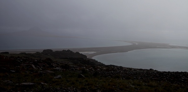
Fig. 1. Arriving on the shoreline opposite Bell Island on a stormy late summer morning in 2013. Note the natural causeway going out to the island.
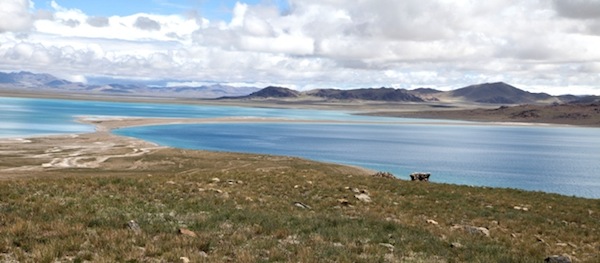
Fig. 2. Looking back towards the mainland from Bell Island later on the same day. The remains of a couple of shrines can be seen against the lake on the middle right side of the photograph.
Nowadays, Bell Island supports a single herder’s seasonal encampment used a few days of the year. What a contrast to ancient times when it was an important center of settlement with fifteen well-built houses and many shrines and other structures! The most remarkable feature of the buildings is that they are relatively well preserved, with around half of the ancient houses still having some or most of their roofs intact. Coming upon these long-abandoned structures is like entering a time machine and being transported back to the distant past.
The houses of Bell Island were constructed in the primary archaic architectural style of Upper Tibet. These are corbelled structures with heavy stone walls and roofs. The very sturdy structures have stood for many centuries. Fortunately, due to the extremely remote location and the harsh environment of the island, these buildings have not been menaced by people in a long time. The structures have endured complete neglect, numerous earthquakes, and the wild elements of the lofty Changthang, but not much else. This is not to be taken lightly in this age of the accidental and willful destruction of many archaeological sites throughout Tibet (and beyond).
Although no direct dating of the structures at Bell Island has not yet been undertaken. We can be confident that they predate the 11th century CE. Moreover, it is quite probable that this island settlement was founded prior to the 7th century CE. It was in the first half of the 7th century that Zhang Zhung, an Upper Tibetan kingdom, ceased to exist as a sovereign state.
Tibetan tradition has it that in the imperial period (circa 650–850 CE), islands at Lake Nam Tsho were claimed by Buddhist ascetics and occupied by no less an eminent personality than Guru Rinpoche. Darok Tsho (Da-rog mtsho), in the western Changthang, remained under direct Bon influence until at least the 11th century CE. This lake is still perceived as being under a Bon pall. According to Bon texts (written as early as the 14th century CE), the great saint Nangzher Löpo (sNang-bzher lod-po) visited the Darok Tsho island of Tsho Do (mTsho-do) in the 8th century CE. This island is described as a very desolate place. It is written that Nangzher Lödpo and his disciple nearly perished from lack of food and support whilst staying on Tsho Do. Yet, Tsho Do was once a thriving insular settlement with well appointed caves shelters, substantial all-stone corbelled houses and a well-designed stronghold. Thus the tale of Nangzher Löpo suggests that the dereliction of the island had already occurred by the time of his visit. Likewise, it appears that other islands of the Changthang were at their zenith in the prehistoric era.
The architectural makeup of residential structures in Upper Tibet also indicates that the all-stone corbelled buildings of Bell Island came up well before 1000 CE (for the typology of these types of constructions, see the March and April 2014 issues of Flight of the Khyung). This typological assessment is corroborated by archaeometric evidence. The ground plan of a residence at Bell Island has been compared to foundations excavated in western Tibet, which are dated to the second half of the first millennium BCE.* The radiocarbon dating of a small round of wood recovered from an all-stone corbelled castle associated with the god Gekhö (Ge-khod) indicates that this installation was already operable 2000 years ago (see Zhang Zhung, pp. 36, 37). The lack of reference in Tibetan literature (Including Bon texts) to residential and cultural centers on the islands also hints at their archaic status. As with the funerary pillars of the region, there are only scant and veiled allusions to the archaeological wealth of the region in early times.
See M. Aldenderfer and H. Moyes, 2004: “Excavations at Dindun, a Pre-Buddhist Village Site in Far Western Tibet” in Essays on the International Conference on Tibetan Art and Archaeology, pp. 47–69. Chengdu: Sichuan Remin Chuban She.The precipitous degradation of the physical environment of Upper Tibet over the last two millennia strongly suggests that the insular settlements are of substantial antiquity as well, belonging to a time when the climate was more amenable to human habitation. There would be hardly any reason to construct an elaborate settlement after stable potable water supplies disappeared from places like Bell Island. Finally, there are no archaeological indications that Bell Island was reinhabited by the Buddhists or Bonpo in any substantive way. The island is devoid of common Lamaist monuments that regularly mark other religious sites such as mani walls and chortens.
The ancient settlement of Bell Island covers about 1 km². Based on the topographical characteristics of the island, it can be subdivided into seven different sectors:
- Lake Vanguard (4655 m): shrines and other minor structures
- Lower Terrace (4695 m): five houses and shrines
- Upper Terrace (4700 m): three houses and various shrines
- South Hollow (4695 m): three houses
- Outcrop sector (4715 m): three houses
- Summit sector (4730 m): one house
- Southeast shrine complex (comparable elevation to the lower elevation houses)
Although the crumbling houses of Bell Island are now mere bare stone hulks, their interiors were once plastered, as traces of this material in the so-called ‘Summit House’ demonstrate. Also, in order to weatherproof and decorate the structures, we can be fairly well assured that their exteriors were plastered and possibly painted too. These buildings average 30 m² to 50 m² in area and contained three to eight small rooms. The random-rubble walls were built primarily of roughly-hewn, dark-colored limestone blocks. The small entranceways of the houses face south and east, directions still favored by contemporary house builders in Tibet. The corbels and bridging stones used to construct the roofs are made of a harder metamorphic stone, cut into pieces up to 1.5 m in length. Much stone working skill went into the creation of the roofs and the walls and foundations needed to support them. These roofs weighed tons, and it is a real tribute to the competency of the ancient masons that they endure at Bell Island.
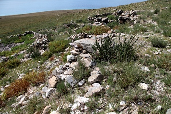
Fig. 3. Part of three closely arrayed houses of the Lower Terrace, Bell Island.
The construction of a corral (visible on left side of image) has helped to obliterate and obscure traces of the three residences. When I first visited Bell Island in 1998, I thought that these remains may have been those of one large structure, but this is not the case. Perhaps these three structures erected side by side were the habitations of an extended family or some other closely knit social group. As I have observed before, I think that at least some of these multi-roomed structures were occupied by family units, not by male anchorites alone. There is no evidence in Old Tibetan ritual texts that the bon and shen priests lived a monastic existence. Furthermore, later texts of the ‘Eternal’ or systematized Bon religion frequently speak of the consorts of these priests and sages.
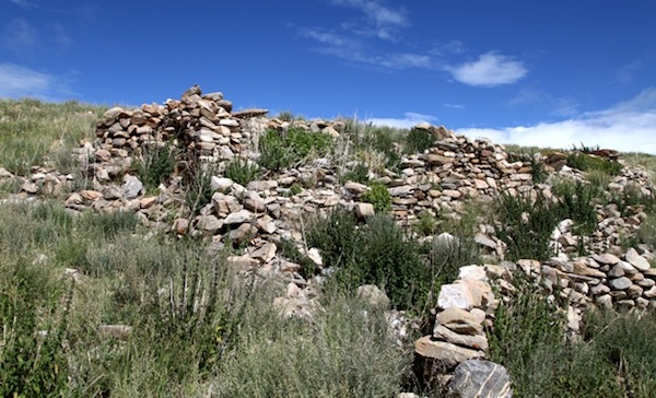
Fig. 4. One of the three closely arrayed houses of the Lower Terrace, Bell Island. Note the long corbel suspended on the rear (upper) wall. This structure was built in three tiers. Some of it was destroyed by the construction of a corral (lower right corner of photo).
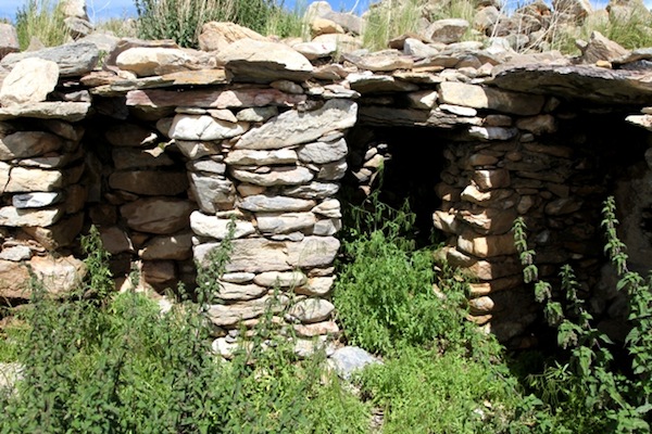
Fig. 5. The central house of the Lower Terrace, Bell Island. Three rear rooms are visible in this image, which still enjoy part of their stone roof.
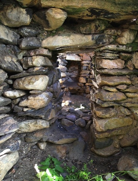
Fig. 6. The central house of the Lower Terrace, Bell Island. Pictured are the central rear room (foreground) and the north room (background) with a large subterranean recess in its northwest wall. Note the massive corbels, bridging stones, and lintel.
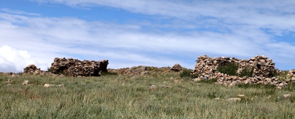
Fig. 7. The south house (left) and central house (right) of the Upper Terrace, Bell Island.
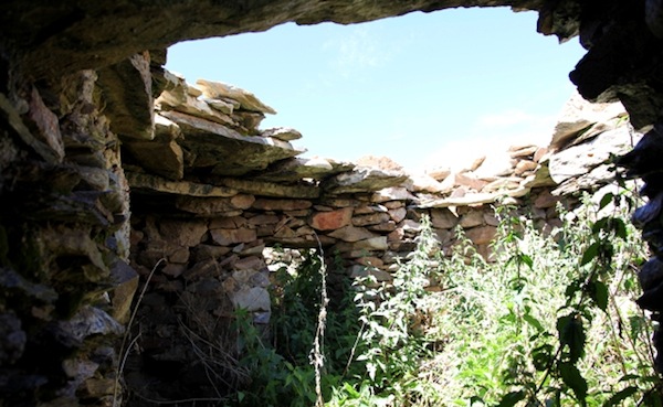
Fig. 8. The south house, Upper Terrace, Bell Island. The rooms of this structure mostly open around a centralized space, an unusual internal design feature in all-stone corbelled constructions. Note the intact entranceway and roof appurtenances.
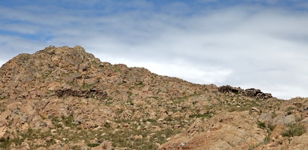
Fig. 9. The south house (left) and central house (right) of the Outcrop sector, Bell Island. The multi-roomed central house is bereft of its roof. The south house has an anterior courtyard and three partly intact rooms in rear.
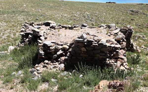
Fig. 10. The north house of the Outcrop sector, from the rear or west, Bell Island. Note the largely intact roof. This is probably the largest single structure on the island. In 1998, I nicknamed it ‘Founder’s House’, on account of its size, relatively good condition and the upright stone in the rear of the edifice. I now prefer the name: ‘Founders House’. Also note the many different outer wall planes in this structure. As all-stone corbelled structures are often composed of multiple structurally self-sufficient units, walls tend to have many projecting angles and indentations. The sandy surface of the roof is what remains of a weatherproof sealant, perhaps a type of natural cement.
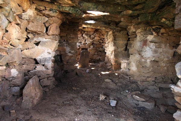
Fig. 11. The open interior of Founders House looking towards the rear (west). The standing stone in the rear is not an original feature, it was placed there relatively recently. This poorly anchored stone is not a stele but rather a roof member. That this stone is not in its original placement is also demonstrated by the manner in which it obstructs access to the rear chambers of the building.
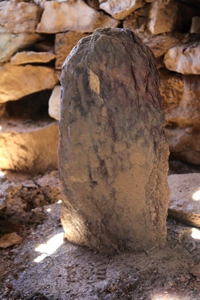
Fig. 12. A close up of the roof member that was erected inside Founders House.
This stone was barely set in the ground and was toppled with a slight shove. Stelae or doring (rdo-ring) in Upper Tibet are more massive stones and much better fixed in the ground. Based on my 1998 survey of Bell Island, Mark Aldenderfer compares this stone with what appears to have been pillars erected inside houses excavated at Dindun (sDings-zlum), in western Tibet.* While similarities between the plans of these structures and Founders House remain valid, we now know from my 2013 survey that there was no standing stone in the latter building.
M. Aldenderfer, 2003: “A New Class of Standing Stone from the Tibetan Plateau”, The Tibet Journal, vol. 28 (nos. 1, 2), pp. 3–20.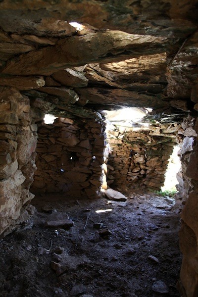
Fig. 13. The interior of Founders House looking east towards the entranceway. Note the massive bridging stones of the partially intact ceiling.
Founders House is very unusual in that its main interior is one large open space. This central space is divided into a six main areas by partition walls. Many different walls and buttresses were necessary to support the great weight of the roof. The main interior space of Founders House measures 6.5 m (east-west) x 3.4 m (north-south). The entrance is against the south wall and opens to a vestibule slightly offset from the central space. In the south central section, there are what appear to be traces of an open hearth. The stone floor of the north central section is elevated above the rest of the floor level, and there is a stone entablature in this alcove. In the northwest section of the structure there is a small walled-off area.
The current maximum floor-to-ceiling height of Founder Houses is is 1.8 meters, but waterborne depositions of earth have covered the original floor to an indeterminate depth. The rear of the building is partially set below ground level, as are other buildings at Bell Island and many other corbelled residences in Upper Tibet. There are three niches (bang-khung) in the interior walls of Founders House. These recesses may have been used for storage or possibly for ritual functions.
On the east side of the central internal space of Founders House are two additional rooms with independent entrances. An open courtyard, as found at many other houses of the site, stands in front of them. One of these rooms has an intact entranceway, which measures 1.4 m from the threshold stone to the lintel, the tallest intact doorway in the houses of Bell Island. The height of this entrance and the large size of Founders House seem to show that it possessed a high status. There is a small window in the north wall of the same room, a unique architectural feature at Trari Nam Tsho. Over the lintel of the well preserved entranceway there is a plaque with the mantras of the three chief bodhisattvas (Rigs-gsum mgon-po) crudely carved into it. This humble plaque is one of only two overt symbols of the Buddhist reoccupation at Bell Island.
On a crag above the Bell Island settlement, there is a cairn with a piece of wood protruding from it. This must have been a mast for the raising of prayer flags at one time. Near the western extremity of Bell Island, there is a cave with an outer chamber no less than 15 m in length with deep accumulations of bird droppings on the floor. On a wall of this cave, the mantras of the three chief bodhisattvas were written in red, white, and beige pigments. They are of significant age, a symbol of the devolution of the island to the Buddhists. With the conversion of most of the region to Buddhism, Bell Island retained very little of its cultural and religious significance. Had it been otherwise, there should be many more Buddhist emblems gracing the island. Below the bodhisattva inscription, there are at least three counterclockwise swastikas painted in a beige pigment. Thus we have graphic representations of both the non-Buddhist and the Buddhist occupations of Bell Island.
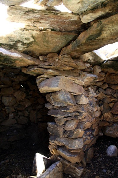
Fig. 14. A wall buttress in the house of the Summit sector, Bell Island. Note how many corbels and bridging stone converge on this wall for support. This arrangement now seems rather precarious.
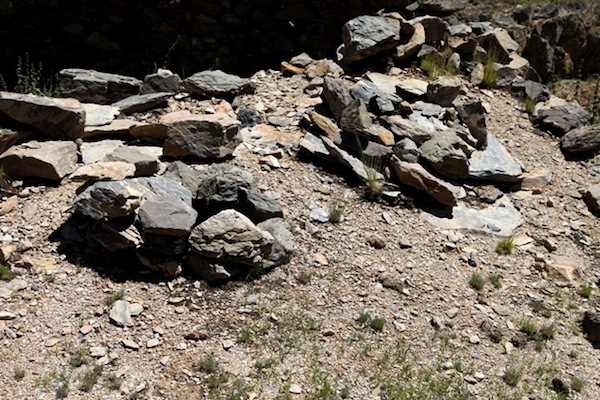
Fig. 15. Circular piles of stones on the roof of ‘Summit House’. They occur over the north and south rear rooms. These appear to be an original architectural feature of the structure, and to have functioned as coverings for smoke holes. The interior of the building could also be ventilated by opening up these stone covers.
Summit House is set directly below the rocky mount that forms the heart of the headland. It consists of a walled courtyard in the east and a group of rooms in the west, with overall dimensions of 5.6 m x 6.2 m. This building once had at least four rooms. The most intact of them is the northwest room (1.8 m x 1.9 m). Its integral entrance measures 90 cm x 45 cm. There are two small niches in the rear (west) of this room now poised at ground level. The more poorly preserved southwest room is a twin of the northwest one. This southwest room also has two niches. The maximum external height of walls in Summit House is 1.8 m, and the current maximum internal height of the two rear rooms is 1.5 m. On the north side of Summit House there were two other rooms.
The ancient ceremonial monuments of Bell Island
In addition to the fifteen residences of Bell Island, a number of shrines and other minor structures stand at the site. These minor structures appear to be an integral part of the island’s ancient architecture, the ceremonial or ritual counterpart to the domiciles. Each residence appears to have had its own household shrine located in close proximity. There are also at least fifteen other shrines not directly attached to the houses. These may have had wider community functions. The existence of at least thirty cubic structures scattered around the settlement suggest that its inhabitants had a rigorous ritual and religious life, as do Tibetans still today.
The cubic masonry structures of Bell Island must have been used in the placation of a variety of spirits. The same types of simple constructions are still being erected in Tibetan villages today. They are called by various names depending on their function and regional location. These include tenkhar (rten-mkhar), tenkhang (rten-khang), sekhar (gsas-mkhar), sekhang (gsas-khang), lhatshuk (lha-gtsug), lhatho (lha-tho), lhaten (lha-rten), tsenkhang (btsan-khang), lukhang (klu-khang), chokhar (lcog-mkhar), pose (spo-se), etc. Generally speaking, these types of shrines are used in the worship of spirits of localized significance, such as those of a territorial or genealogical nature. As is well known, Tibetan settlements and monasteries have a variety of different protective deities, which often merit the raising of shrines of the kinds enumerated.
The cult of local protective and lineage deities has every indication of being an ancient feature of Tibetan civilization. The existence of actual ruined shrines and their depiction in the rock art of many sites in Upper Tibet supports the antiquity of this tradition. In contemporary Tibet, there are shrines for the elemental spirits and other gods that preside over topographical features, villages, families, and clans. They range from crude piles of stones to simple cubic structures to elaborate edifices that can be entered (such as the three-story tall Thanglhai Tenkhang located south of Damshung).
Especially in western Tibet, stepped structures consisting of three to seven graduated tiers can still be found. The Bon tradition traces this particular architectural form back to Zhang Zhung and the worship of its chief god, Gekhö (Ge-khod; see my book Zhang Zhung, pp. 252–258). The stepped shrine is the most common type portrayed in the rock art of Upper Tibet, indicating that there is some validity to this Bon historical tradition despite its mythic overlay. As I have stated in previous publications, it appears that stepped shrines were one source of architectural inspiration for the Tibetan chortens, which first appeared circa the 7th century CE and which prevail to the present day. The other and perhaps more important source of architectural and religious inspiration for the Tibetan chorten was the Buddhist stupa of northwestern India.
Shrines for the cult of protective deities are furnished and ornamented in great variety of ways. They often contain a ‘support’ (rten), where the selected deity or an aspect of it can alight and dwell. Typically, these supports consist of vases, chests, sacred stones, weapons, horns, juniper boughs, graven images, or even an empty masonry chamber. As is well known, among the rituals carried out at shrines for elemental and other protective deities is the burning of aromatic substances, the raising of prayer flags, and the giving of sundry offerings.
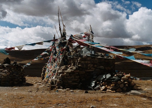
Fig. 16. A contemporary shrine in Upper Tibet similar in form to some of the ancient ones examined below.
This active Buddhist shrine is dedicated to the famous mountain god Nyenchen Thanglha (gNyan-chen thang-lha). Called Thanglhai Sangkhuk (Thang-lha’I bsang-khug: ‘Incense Nook of Thanglha’), it is situated on the foot of the holy mountain at a place called Rin-chen Pungpa (Rin-chen dpung-pa, ‘Jewelled Shoulder’). This location is visualized as the shoulder of the mighty mountain god. The base of the shrine is filled with molded clay plaques (tshwa-tshwa). Reportedly, in the center of the shrine there is a sealed structure enshrining a vase filled with sacred substances consecrated to the mountain god. Incense offerings are made nearby in an incense brazier (bsang-khang). In the pre-Communist period, the Tibetan government conducted an annual incense ritual at Rinchen Pungpa called Thangsöl (Thang-gsol). In the Chinese Cultural Revolution, the shrine complex was desecrated, and subsequently rebuilt.
I have diverged a bit from the cubic structures of Bell Island to furnish readers with an account of contemporary shrine building and usage because it is an excellent example of how ethnographic data can be applied to the archaeological record. However, I do not propose that the practice of rituals and religion in pre-Buddhist times was identical to today, for everything we know suggests that it was not. Nonetheless, there are certain material and abstract elements of archaic ritual practice that have endured in the contemporary cult of protective deities. What precisely these are and how specifically they relate to ancient practices is open to interpretation and not easily settled. Therefore, as readers view the ancient shrines depicted below, keeping in mind the present-day cultural scene in Tibet for perspective, they should also remember that change over time distinguishes human affairs. Moreover, cultural changes may occur in unremarked or disguised ways.
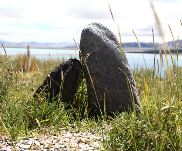
Fig. 17. Twin long stones (rdo ring) one light-colored and one dark-colored, on the Upper Terrace, Bell Island. The larger specimen is 50 cm in height. The manner in which these two well anchored stones have titled towards each other suggests that they have stood for a long time. More recently in Tibet, standing stones were erected when a new building foundation was consecrated, for the worship of deities, and for oath-taking. It is not known how these traditional practices might relate to the two stones shown.
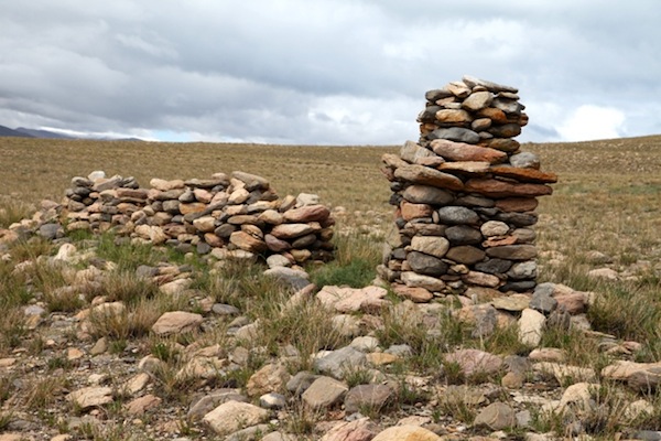
Fig. 18. A rudimentary shrine and wall, Lake Vanguard sector, Bell Island. The form of this shrine is immediately recognizable to modern-day Tibetans, for their shrines still take the same shape. It consists of a square base, overlapping middle courses and a smaller top section. Originally, the topmost portion may have been a spherical structure (bum-pa), a fundamental element of Tibetan chorten construction since the 7th century CE. Note the orange climax lichen growing on the shrine.
There are seven such simple shrines in various styles of construction situated some 35 m above the current lake level. Some of them are in an advanced state of degradation. These structures appear to be an integral part of the Bell Island settlement. Given the lake level figures provided in the introduction to this article, these shrines could not have been constructed before the first millennium BCE. As with the rest of the settlement, they are likely to have been established prior to the 7th century CE and almost certainly before the 11th century CE. Whenever they came up, these shrines once lay closer to the water’s edge than they do today.
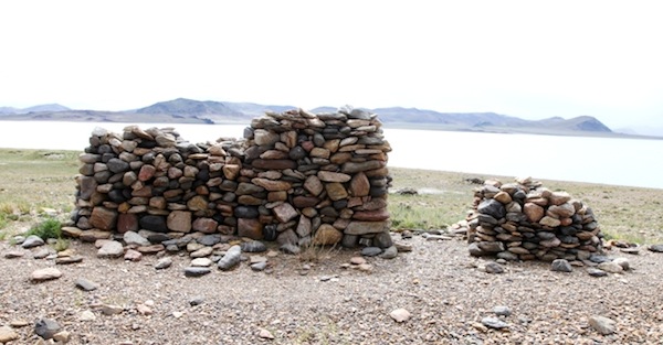
Fig. 19. Two other Lake Vanguard shrines with the waters of Trari Nam Tsho in the background. These shrines were established on one of the many receding ancient shorelines of the lake. Now just bare stone hulks, these structures may have originally been cemented with mortar and encased in plaster.
As I observed in Antiquities of Northern Tibet, the placement of the Lake Vanguard shrines suggests that they may have been employed in the placation of the lake goddess of Trari Nam Tsho. Such shrines for lake goddesses are still found on the shores of Lake Dangra Yumtsho, Lake Nam Tsho, and other sacred lakes of Upper Tibet. The ones at Bell Island have a southeast orientation, the direction from which much of the precipitation of the region originates. The growing salification of Trari Nam Tsho must have been a matter of grave concern to the early residents of Bell Island and other settlements around its waters. Thus, we can imagine that a host of ritual means may have been used in an attempt to revive the lake.
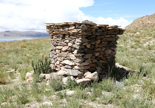
Fig. 20. Well-built shrine between the Upper Terrace and Outcrop sector, Bell Island. Note the small square opening on the east-southeast (left) side of the structure. Above it thin slabs of stone were used to construct the overlapping courses of the structure. The top of the structure has been obliterated.
A line of six other shrines in various states of preservation follow the rim of the sloping Upper Terrace and directly overlook the lake above the isthmus. This orientation and that of the opening in the structure pictured in fig. 19 seem to suggest a strong relationship with Trari Nam Tsho. Nonetheless, the openings of many shrines face east, the direction most favored for the placation of deities, as well as for many other kinds of ritual performances.
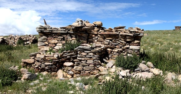
Fig. 21. Twin shrines (3.2 m x 4.8 m) of the Upper Terrace, the largest and best preserved ceremonial monument at Trari Nam Tsho. Built in the same way as others we have examined, the piles of stones on top of the extant structure suggest that they once were once significantly taller. Structural extensions in front (east) of the twin shrines indicate that these were quite elaborate constructions. Note the square opening in each shrine. To the left is one of the houses of the Upper Terrace. On the upper right side, the shrine in fig. 19 is visible.
Contemporary Tibetan cubic shrines often have an opening in the wall facing the direction in which ritual activities take place. The opening is conveyed to the center of the structure, the location of the key support or tabernacle of the presiding deity. The aperture is often envisioned as the portal relied upon by the deity to gain access its dwelling place. A similar conceptual arrangement may be implied in the shrine architecture of Bell Island. Historically and architecturally, niches found in the rounded section of certain Tibetan chortens can possibly be attributed, at least in part, to the openings found in the archaic shrines of Upper Tibet (early Buddhist stupas of the Indian Subcontinent have niches in the bum-pa).
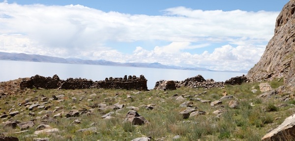
Fig. 22. The largest shrine complex of Bell Island. It is located on the south side of the island, nearly 1 km west of the settlement.
This isolated shrine complex is built on a rocky shelf poised nearly 100 m above Trari Nam Tsho. It is dominated by a long structure oriented southwest-northeast. This structure is interrupted by a 1.7 m wide gap in which passes the faint trail around the headland. The southwest part of this structure is 19.2 m long and the northeast half 14.5 m long.
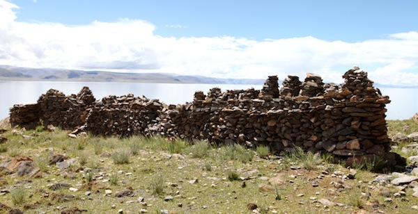
Fig. 23. The southwest part of the long shrine. Note the row of 17 vertical extensions or merlons sitting on the base of the structure. Some of these have been almost leveled.
This shrine is 2 m to 2.5 m in height. Near the top of the base there are two courses of long, thin bond-stones in the otherwise random-rubble fabric of the structure. Of special interest is the row of merlons. Although they now seem pyramidal, these are the remains of rounded or tiered structures that once surmounted the shrine. Only one such merlon still stands on the northeast part of shrine. This is the only shrine of its kind discovered in Upper Tibet. A few early chortens in Upper Tibet have two or more rounded or stepped sections erected on a single rectangular base,* but never in the numbers found on the Bell Island shrine. The ceremonial structure at Bell Island is probably the precursor of these unusually designed chortens (we will examine them in another issue of this newsletter).
For an example of this type of chorten, see the Sa rā site entry, Antiquities of Zhang Zhung: http://www.thlib.org/bellezza/#!book=/bellezza/wb/b1-2-54/Like other facets of the island’s ceremonial infrastructure, the long shrine can be attributed to archaic-era religious practices. Nevertheless, long lines of similarly shaped merlons set atop boundary walls have been identified in Ladakh and Guge. The Ladakh example is found at the long ruined Dorje Chenmo chapel of Nyarma, a small building that may date to the early historic period (see June 2013 Flight of the Khyung). The merlons of Nyarma appear to have given rise to rounded structures (bumpa).
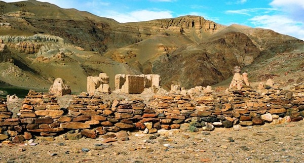
Fig. 24. A small section of the boundary wall with chorten-like extensions at a ruined Buddhist monastery, Bedongpo (sBrel gdong-po), Guge. There are dozens of merlons on this long and winding wall.
This ruined monastery is one of two found near the contemporary village of Bedongpo. We shall call it Bedongpo South for lack of a better name. The plan of the rammed-earth buildings and the style of the large chortens indicate that this was a ‘second diffusion’ Buddhist religious site, built in the 11th or 12th century CE.
Based on my suggested chronology, the use of merlons seems to span the prehistoric era (pre-7th century CE, early historic period (650–1000 CE), and what I often call the vestigial period (1000–1250 CE). The ritual functions, symbolism and finished forms of these structures are likely to have varied with time, but the merlon as either a stepped or rounded structure in its finished form remained part of the vernacular architecture of western Tibet. An architectural parallel characterized by much historical persistence is the use of herringbone courses of masonry in large structures. These have been dated to circa the 4th century CE of the protohistoric period and to the 10th century CE (see the book Zhang Zhung, pp. 146, 148).
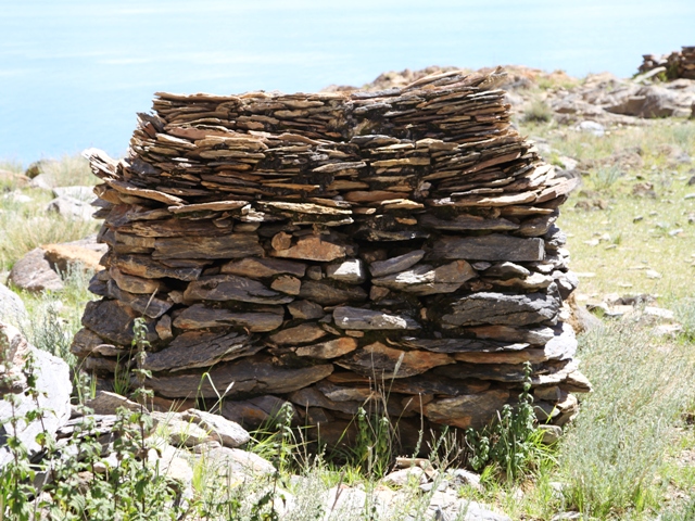
Fig. 25. The better preserved of two small shrines beside the example in figs. 22 and 23.
This uniquely designed structure stands less than 2 m in height. The top portion is built from extremely thin slabs of stone laid on top of one another. There are around twenty vertical courses of slabs to attain a height of just 60 cm. The multiple courses of thin stones now bow inward due to subsidence over the centuries. The moss and impacted earth in the seams of this shrine is also an indicator of its considerable age.
The largest archaic shrine complex discovered in Upper Tibet
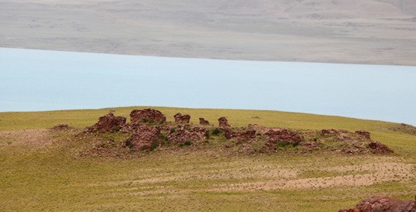
Fig. 26. The shrine complex of Chorten Mukrang standing above the waters of Lake Dangra Yumtsho. This group of shrines was built on a natural rise elevated 4 m above the surrounding shelf (elevation 4690 m). The axis of the rocky crest and man-made complex is oriented northeast-southwest. There are between twenty-five and thirty shrines at this site spread over a linear distance of roughly 70 m. Many of the structures are now in a poor state of preservation.
The largest archaic shrine complex discovered in Upper Tibet is situated not far from one of the citadels described in last month’s newsletter. This impressive relatively well-preserved complex is called Chorten Mukrang (mChod-rten smug-rang). In my book Divine Dyads, influenced by the oral tradition, I called the various ceremonial monuments at this site “chortens”, the common Lamaist shrine found throughout Tibet. Despite what local sources say, these structures are certainly not chortens, at least of the kind recognizable today.
The structures of Chorten Mukrang are best categorized as archaic shrines of the type discussed above. As old-style ceremonial monuments are not constructed on such a large scale in Upper Tibet any longer, it is readily understandable how they have become confused with the well-known chorten. The archaic cultural status of the site is underscored by the complete absence of Lamaist emblems. There are no inscribed plaques, prayer flags, incense braziers, horns of livestock, or any other sign of contemporary worship or historical acknowledgment at Chorten Mukrang. At such a large site, this would be unusual if we were dealing with Lamaist chortens, but it is par for the course when archaic monuments are involved.
The shrines of Chorten Mukrang appear to be of uniform design and construction and are very close in form to those illustrated in figs. 20 and 21. They are built primarily of roughly-hewn, red sandstone slabs and blocks up to 80 cm in length (most fall between 15 cm and 40 cm in length). These stones were laid in random-rubble courses but there are also walls of coursed rubble.
The precise age of Chorten Mukrang remains unknown at this juncture of the investigation. Nevertheless, we can be confident that this large complex of shrines was founded before 1000 CE. Given their design and construction, however, they are probably best dated to the pre-7th century CE period, as authentic examples of what might be called Zhang Zhung or archaic ceremonial architecture. The lack of any contemporary use or religious regard of the site also suggests a pre-Lamaist periodization.
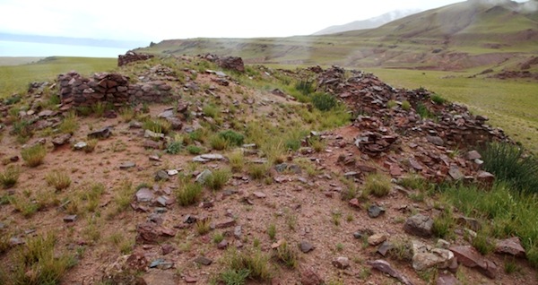
Fig. 27. A view of the middle section of Chorten Mukrang. The structures here are up to 2.5 m in height and 5 m in length. They have square and rectangular plans.
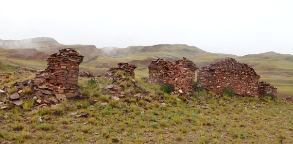
Fig. 28. Five better preserved shrines of Chorten Mukrang. It is obvious that above the overlapping courses of masonry there were substantial constructions but their design is not very apparent. The heaping of stones suggests that these were either tiered or bulbous constructions inset from the courses of masonry below. It is clear that these were sophisticated constructions reflecting the lavish ritual and ideological life of the builders and users.
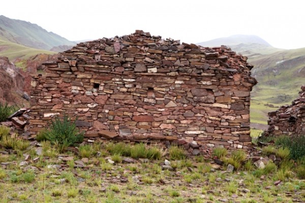
Fig. 29. A close up of the largest shrine in fig. 28. Note the three orifices in the upper base of the structure. These opening face onto the lake, possibly suggesting that the shrines (at least those facing the lakeside) were erected in honor of the goddess of Lake Dangra. The rectangular base of the shrine sites on a plinth, adding to its structural integrity.
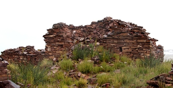
Fig. 30. Another example of a large and relatively well preserved shrine, Chorten Mukrang. Note the two prominent openings in the base (one with a stone lintel). These apertures face away from the lake. As the structure has subsided over the centuries and been subjected to other destructive forces, it is not clear how large were the interior chambers they access. Also, note the tapering courses of masonry that make up the top half of the structure. These courses appear to have created a tiered structure, like those commonly depicted in the rock art of Upper Tibet. This shrine may have been substantially taller than at present.
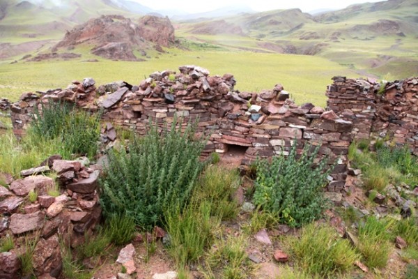
Fig. 31. Another large shrine with an extension that runs in a perpendicular direction, Chorten Mukrang. Note the two apertures in the base.
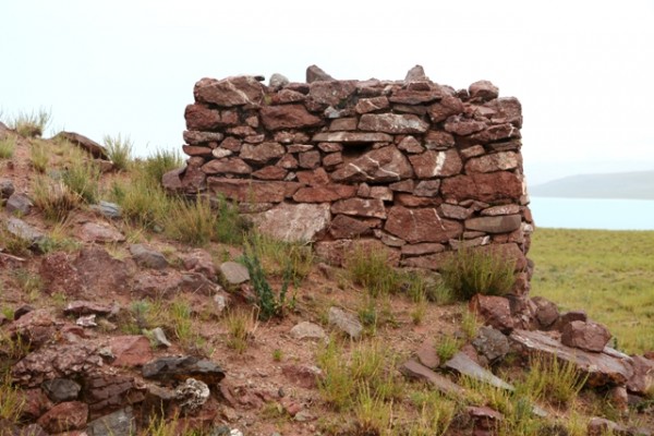
Fig. 32. An example of a smaller shrine at Chorten Mukrang. It also has the characteristic opening in the base.
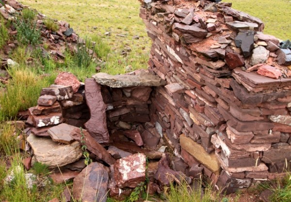
Fig. 33. Another shrine at Chorten Mukrang. Note the in situ bridging stone and corbel in the more leveled half of the structure. This architectonic evidence confirms that this shrine was an all-stone corbelled construction, as were most of the buildings at the nearby fortified settlement.
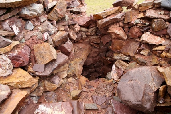
Fig. 34. The guts of another shrine, Chorten Mukrang. Here too we can see that this was an all-stone construction. The remains of the central chamber pictured here must have been used to enshrine materials that served as the tabernacle of the deities for whom the monument was erected. I would expect that these shrines were looted long ago, as it seems were many large tombs and other prominent archaic ceremonial structures in Upper Tibet.
Next month: More ancient surprises!