
April 2014
John Vincent Bellezza
Welcome to the Flight of the Khyung! This month the horned eagle takes you to four of the great citadels of Lake Dangra Yumtsho. According to the oral tradition of the region, these ancient strongholds were constructed during the time of Zhang Zhung, an Upper Tibetan kingdom that existed until the 7th century CE. See here for the first time a collection of images that help to portray the high level of civilization attained in Upper Tibet centuries before Buddhism came to dominate the Plateau. Let us begin this month’s offerings though with a new Himalayan archaeological discovery.
Tombs recently discovered in the High Himalaya of India
An article on the recent excavation of tombs in the Kinnaur district of Himachal Pradesh has been published in Antiquity (vol. 88, no. 339, March 2014). It is entitled “Lippa and Kanam: Trans-Himalayan cist burial culture and pyrotechnology in Kinnaur, Himachal Pradesh, India”, by Vinod Nautiyal et al (six authors). While cist burials have been discovered near a number of Kinnauri villages in the past, this paper focuses on those of Lippa and Kanam. These two villages are nestled right along the very axis of the Great Himalayan Range at the junction of the central and western provinces of this mountain chain. Lippa and Kanam are subject to the climatic and environmental conditions of both the cis-Himalayan and trans-Himalayan zones (with Kanam being decidedly drier and more trans-Himalayan in character).
According to the Nautiyal et al paper, three tombs were opened at Lippa, which contained human remains and cylindrical steatite beads. In a stone-lined tomb in Kanam, in addition to a complete human skeleton of an elderly male, redware vessels, charcoal, iron implements, the horn of a ruminant, and other bone remains were recovered. The corpse was found with copper bangles that once wound around both wrists. The radiocarbon and OSL analysis of the Kanam remains indicate that they date to the 7th to 5th centuries BCE. According to the authors of the study, these burials “demonstrate the integration of the area within the wider Trans-Himalayan burial culture of Uttarakhand, Mustang in Nepal, and western Tibet.” The authors also observe that the pottery discovered in Kanam is “very similar” to that found in Malari (Uttarakhand), Mustang, and western Tibet. The authors thus state: “This suggests that a common ceramic tradition developed across a large tract of the Trans-Himalayan region and the Upper Tibetan Plateau, though practicing different burial traditions.” More excavations are promised for 2014.
For the Nautiyal et al. paper see: http://antiquity.ac.uk/projgall/
The authors of the Kinnaur study are certainly right to highlight structural similarities between burials over a wide territory and encompassing both cis-Himalayan and trans-Himalayan regions. For one thing, the affinities in ceramic forms are undeniable. Their observation that these material parallels occur along with the practice of different burial traditions is also a very important distinction. There are no archaeological indications that the regions of Himachal Pradesh, Uttarakhand, Mustang, and western Tibet were all part of the same culture, spoken language, or ethnicity. In fact, the diversity in the style of material objects (ceramics, golden burial masks, implements, etc.) thus far recovered in these regions is reflective of considerable cultural variability. Similarly, ethnographic and literary records (Tibetan and Sanskritic) militate against the idea of a unitary super-culture spread out over the entire region.
What the structural similarities in mortuary archaeology do show is that various technologies, funerary architecture, burial customs, perhaps even fashion tastes had wide currency in the greater Himalayan region during the Iron Age. This strongly suggests that well developed lines of trade and other forms of communications were already in place. Genomic studies conducted to date indicate that there was little genetic drift between the Tibetan plateau and the plains of India. Nevertheless, common mortuary patterns may reflect the infiltration of genes across the Himalayan divide to the high mountain tracts of India and Nepal some 2500 years ago. We shall see in due course. As more archaeological data is assembled, we will be able to better assess how Himalayan and Tibetan Plateau peoples once interacted with one another. The results may prove quite exciting.
Chronicles in Stone: The ancient fortresses of Lake Dangra Yumtsho
Introduction
Lake Dangra Yumtsho (Dang-ra g.yu-mtsho) is a most noteworthy location geographically, culturally, historically, and esthetically. This largest lake in the central portion of Upper Tibet is home to one of the greatest concentrations of ancient monumental architecture in all of Tibet. Sacred Lake Dangra is situated at the relatively low elevation of 4535 m, making it fit for the practice of agriculture. Local tradition holds that barley and turnip cultivation has taken place at Lake Dangra since time immemorial. While the archaeobotanical study of this most remote agricultural enclave in Tibet is still pending, it appears that a number of unique strains of barley and turnips are grown here. According to villagers, the local variety of turnips known as trolo (khro-lo), which are specially adapted to very high elevation conditions, is an ancient crop.
Being low enough in elevation (climate also moderated by the lake) to support agriculture means that Lake Dangra developed very differently from many other regions of the high plains (Byang-thang) of Upper Tibet. The growing of food crops allowed a string of villages to appear near the lakeshore. As we saw in last month’s newsletter, some of these villages are at least a 1000 years old. Nevertheless, this legacy of the last millennium is but a rather recent chapter in the history of Lake Dangra. Earlier phases of occupation are documented in more than two dozen sites consisting of citadels, palaces and temples. These impressive ruins allude to a period when human settlement at Lake Dangra was more highly developed than in anytime in the last 1000 years. Where enough of the early ruins have endured, it can be determined that these facilities were built entirely of stone with corbelled roofs, in the archaic manner of construction.
The all-stone corbelled edifices of Lake Dangra belong to an era when the cultural, technological, and economic resources of the region were at their zenith. According to the local oral tradition, this period coincided with the Zhang Zhung kingdom. During that time Lake Dangra is supposed to have ruled over the surrounding areas, a very large territory claimed by its kings. Zhang Zhung still looms large for the inhabitants of Lake Dangra, because many of them belong to the Bon religion.
Bon texts claim that the powerful kingdom of Zhang Zhung existed for many centuries, if not millennia, before it was conquered by the Central Tibetans in the 8th century CE. Older accounts written in the Old Tibetan language paint a complementary but somewhat different picture. These sources speak of treachery and the assassination of the last Zhang Zhung king, Liknyashur (Lig-snya-shur), in the 640s CE. Rather than a frontal assault, devious means were used to bring down Zhang Zhung, as if Central Tibet faced a formidable enemy.
There are numerous sources in English and in French pertaining to the history of Zhang Zhung. Among the most extensive are the following:
Bacot, J., Thomas, F. W. and Toussaint, Ch. 1940–1946. Documents de Touen-houang relatifs à l’histoire du Tibet. Annales du Musée Guimet. Paris: Librairie Orientaliste Paul Guenther.
Bellezza, J. V. 2008. Zhang Zhung: Foundations of Civilization in Tibet. A Historical and Ethnoarchaeological Study of the Monuments, Rock Art, Texts and Oral Tradition of the Ancient Tibetan Upland. Philosophisch-Historische Klasse Denkschriften, vol. 368. Wien: Verlag der Österreichischen Akademie der Wissenschaften.
_____2011. “Territorial Characteristics of the Pre-Buddhist Zhang-zhung Paleocultural Entity: A Comparative Analysis of Archaeological Evidence and Popular Bon Literary Sources”, in Emerging Bon: The Formation of Bon Traditions in Tibet at the Turn of the First Millennium AD (ed. H. Blezer), pp. 51–116. PIATS 2006: Proceedings of the Eleventh Seminar of the International Association for Tibetan Studies, Königswinter 2006. Halle: International Institute for Tibetan and Buddhist Studies GmbH.
_____In press. The Dawn of Tibet: Ancient Roof of the World. Lanham: Rowman & Littlefield. For a synopsis, photo of the cover and ordering information, see https://rowman.com/ISBN/9781442234628
Dotson, B. 2009. The Old Tibetan Annals. An Annotated Translation of Tibet’s First History. Philosophisch-Historische Klasse Denkschriften, vol. 381. Wien: Verlag der Österreichischen Akademie der Wissenschaften.
Hummel, S. 2000. On Zhang-zhung (trans. G. Vogliotti). Dharamsala: Library of Tibetan Works and Archives.
Macdonald, A. 1971. “Une lecture des Pelliot tibétain 1286, 1287, 1038, 1047, et 1290. Essai sur la formation et l’emploi des mythes politiques dans la religion royale de Sroṅ-bcan sgam-po” in Études Tibétaines dédiées à la mémoire de Marcelle Lalou (ed. A. Macdonald), pp. 190–391. Paris: Adrien Maisonneuve.
Norbu, Namkhai, C. 2009. The Light of Kailash: A History of Zhang Zhung and Tibet, vol. 1. Merigar: Shang Shung Publications.
_____1995. Drung, Deu and Bön. Narrations, Symbolic languages and the Bön tradition in Ancient Tibet (trans. A. Clemente and A. Lukianowicz). Dharamsala: Library of Tibetan Works and Archives.
Richardson, H. E. 1998. High Peaks, Pure Earth. Collected Writings on Tibetan History and Culture. London: Serindia Publications.
Uray, G. 1972a. “Queen Sar-Mar-Kar’s Songs in the Old Tibetan Chronicle” in Acta Orientalia Academiae Scientiarum Hungaricae, vol. 25, pp. 5–38. Budapest.
Vitali, R. 2008. “A tentative classification of the Bya ru can kings of Zhang zhung” in Tibetan Studies in Honour of Samten Karmay, part II, Revue d’Etudes Tibétaines, no. 15, November, 2008, pp. 379–419.
http://himalaya/socanth.cam.ac.uk/collections/journals/ret/pdf/ret_15_10.pdf
We can be quite confident that some of the ancient castles and temples of Lake Dangra do indeed date to the time of Zhang Zhung. Others may have been built and used as late as the imperial period (circa 650–850 CE), while others still may have been founded as early as the first millennium BCE. Iron Age monuments at Lake Dangra may belong to polities that pre-date the kingdom known in Tibetan and Chinese literature as Zhang Zhung (Chinese = Yangtung). Although cultural continuities are strongly ingrained in the historical and archaeological records (linguistic continuities are also indicated), Old Tibetan textual evidence suggests that alternative tribal designations were the most ancient place names for the Upper Tibetan region (for more information, see the June 2013 Flight of the Khyung).
More research is needed to establish the precise chronology of ancient sites at Lake Dangra. Until that time we can only speak in general terms about this remote but vital juncture in the history of Tibet. What is clear is that settlement patterns of the last 1000 years differ sharply from earlier ones. The last millennium at Lake Dangra is characterized by villages, monasteries, and cave retreats built with wooden roofs in styles of architecture that still prevail in Tibet. The antecedent epoch is marked by high-elevation, large complexes constructed using sophisticated designs and techniques that have long since disappeared from the Tibetan architectural canon. A case in point is the archaic fortresses of Lake Dangra.
Gyampai Dzong
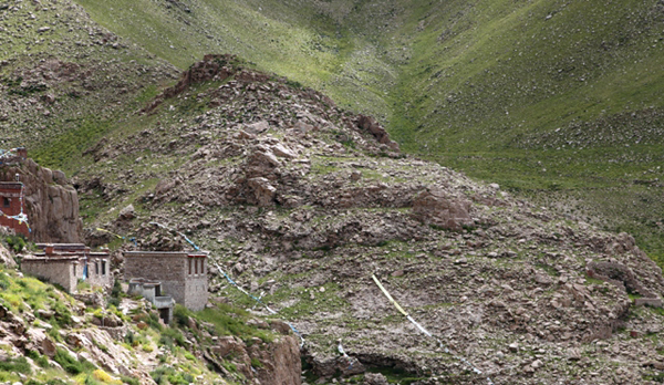
Fig. 1. The conical mount upon which Gyampai Dzong was stood. On the left side of the image some of the buildings of Yubun Gonpa (g.Yu-bun dgon-pa: ‘Turquoise Mist Monastery’), an ancient Bon monastery, can be seen.
Along the rugged east shore of Dangra Yumtsho, bisecting the middle of a mountain cove, is a rocky mount towering 230 m above the clear blue waters of the lake. The south and west sides of this conical mount are littered with the ruins of stone buildings. Known as Gyampai Dzong (Gyam-pa’i rdzong: ‘Rock Shelter Fortress’), these structures constitute one link in the chain of strongholds located around Lake Dangra. Occupying no less that 6000 m², Gyampai Dzong has every indication of being a key ancient site. This hard-to-reach location is hidden away, remaining invisible until one is practically upon it. In the immediate vicinity are a number of sacred caves, including those that appear to have been inhabited in ancient times.
Architectonic evidence demonstrates that the dense array of buildings at Gyampai Dzong were constructed with corbels and all-stone roofs, the most distinctive genre of archaic residential architecture in Upper Tibet. According to local elders interviewed over the last two decades, Gyampai Dzong was a Zhang Zhung installation. Lopon Tenzin Namdak, Bon’s senior-most scholar, adds that Gyampai Dzong was associated with the Likmigya (Lig-mig-rgya) kings, a dynasty based at Lake Dangra. For more on Gyampai Dzong and Yubun Gonpa, see my book Divine Dyads (for bibliographic details, go to the book link on this website).
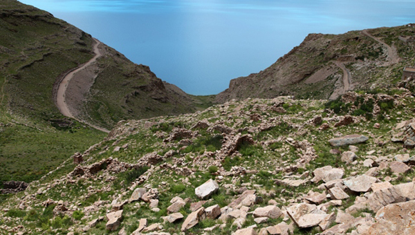
Fig. 2. Densely packed ruins extend along a shoulder on the south and west sides of the Gyampai Dzong mount. Shown here is considerably less than 50% of the entire fortress. This large stronghold was much more extensive than Yubun monastery. It appears that originally the Yubun locale, an inherently less secure place for defensive purposes, was an ancillary site attached to Gyampai Dzong. Dozens, if not several hundred people must have once resided in the buildings of Gyampai Dzong. Note the new road running along the slopes below the fortress. This road was finished in 2013, allowing access by motor vehicles.
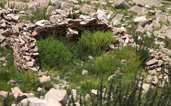
Fig. 3. A building with an in situ corbel and wall buttress (middle of rear wall), characteristic features of all-stone corbelled architecture in Upper Tibet. This structure is one of the only examples remaining at Gyampai Dzong to retain a direct indication of the roof type. Dozens of such structures once covered the slopes, small, easy to heat, windowless buildings. That the corbelled buildings of Gyampai Dzong, an extremely durable form of architecture, are in an advanced state of disintegration seems to suggest that the site was subjected to a cataclysm. Note the orange climax lichen on some of the stones of the pictured edifice.
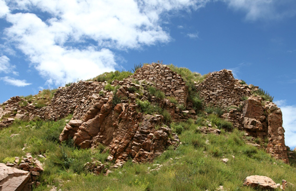
Fig. 4. High elevation revetments shoring up the summit of Gyampai Dzong. This kind of prominent random-rubble and often dry-stone retaining wall is a common feature of all-stone corbelled buildings in Upper Tibet.
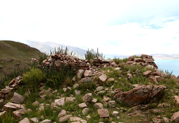
Fig. 5. The very summit of Gyampai Dzong. According to the local oral tradition, a palace once stood here. Likewise, in the historic era, high status structures were often situated on the loftiest portions of Tibetan castles and fortresses.
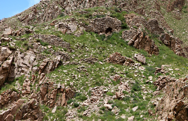
Fig. 6. The summit and southern flanks of Gyangpai Dzong. The uniform design qualities and state of degradation of Gyampai Dzong suggests that it may have been built as an integrated facility. The location is inherently defensible, indicating that it did indeed function as a citadel. Its stronghold status is corroborated by the presence of ramparts at the site.
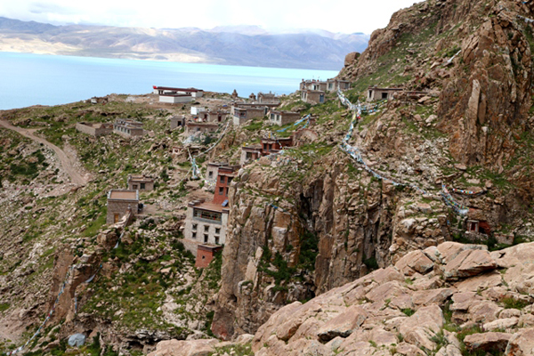
Fig. 7. The monastery of Yubun viewed from Gyampai Dzong. The oldest portion of the monastery is in the foreground beside the cliffs. It is written that Yubun Gonpa was founded in the time of Central Tibet’s second king, Mutri Tsenpo (Mu-khri btsan-po). This semi-mythic king is thought to have lived circa the 1st century BCE. If this historical conception is valid, Yubun is one of Tibet’s oldest continuously inhabited religious sites. In any case, the presence of important holy caves at the site, suggests that it does indeed have a very long history behind it.
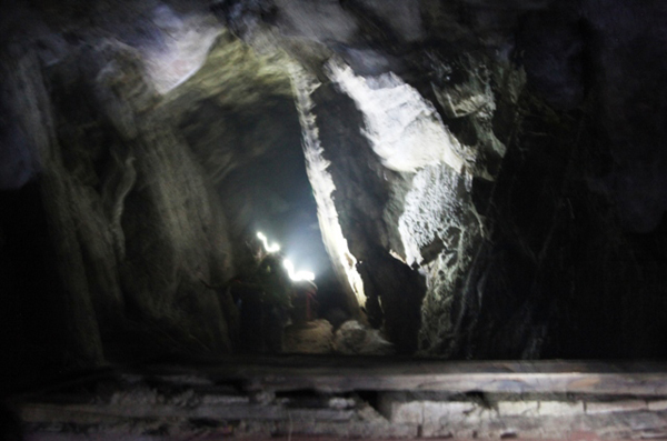
Fig. 8. The marvelous cave at the heart of Yubun Gonpa. It is considered the soul cave (bla-phug) of Lake Dangra, and represents the heart of the anthropomorphized lake goddess Dangra Gyalmo (Dang-ra rgyal-mo). This grotto also enshrines the central figure of a pentad of Bon tantric goddesses who have the heads of carnivorous creatures. This religious practice cave (sgrub-phug) is recorded as being the haunts of Sene Gau (Sad-ne ga’u), a Zhang Zhung era sage who lived beside Lake Dangra with his consort Lucham Barma (Klu-lcam ’bar-ma).
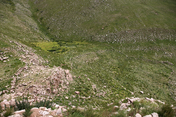
Fig. 9. The vestiges of fields located on the south side of the Gyampai Dzong mount, which are said to have been cultivated in Zhang Zhung times. Wall traces along the terraces are still visible. Higher up the slopes it is said that there was once a juniper forest, but not one tree remains today.
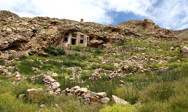
Fig. 10. The cave facade of Gyampai Lhakhang, situated on the southern foot of Gyampai Dzong. This natural cave is purported to have functioned as a temple in the age of Zhang Zhung. Gyampai Lhakhang is the single largest cave at Lake Dangra. This ancient residence was in a state of neglect until the new facade was built nearly 25 years ago. Note the terraced walls below the cave, the remains of agricultural plots according to the oral tradition. A few lower agricultural plots are still in use at the locale.
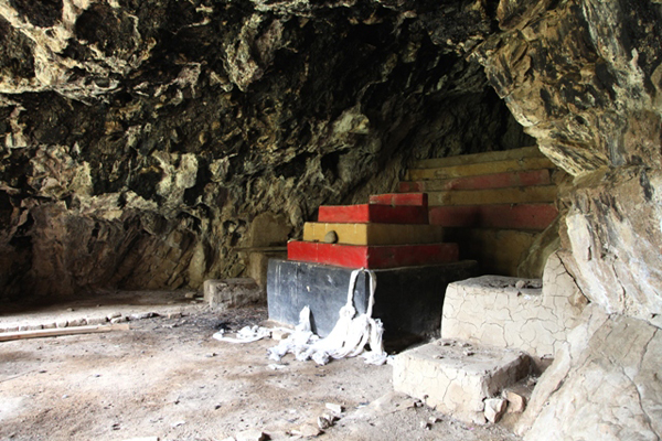
Fig. 11. The interior of Gyampai Lhakhang. The tricolored stone and adobe altar pictured was built during the renovation of the cave more than two decades ago. As can be seen in this image, Gyampai Lhakhang is the subject of very little contemporary use.
Arpo Dzong
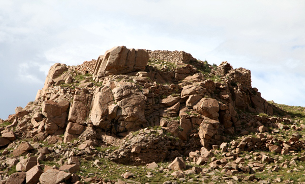
Fig. 12. The south side of the rocky eminence upon which Arpo Dzong reposes. This ancient stronghold has been reduced to its foundations and revetments.
Arpo Dzong (Ar-po rDzong: ‘Bandits Fortress’, regional var. of Ar-pa) occupies a rocky knob, just west of the old village of Kyisum (sKyid-gsum). It is one of three strongholds in Kyisum that local residents allege were constructed in the Zhang Zhung period. The name of the village is said to be derived from these three fortresses. This compact installation appears to have covered the rocky knob on which it was built. The leveled summit complex measures approximately 20 m x 5 m. Despite the highly degraded condition of the ruins, it can be determined that the buildings of Arpo Dzong were of an all-stone corbelled variety. The wall alignments and composition, as well as the extant stone roofing members say so much.
From one or more of the three fortresses of Kyisum, traffic around the east shore of Lake Dangra must have been regulated. Any surpluses from local agricultural holdings in Kyisum and nearby Lhalung village (much more extensive in the past) would have provided some of the wherewithal to build and occupy the triad of fortresses. Trade and other economic factors are also likely to have been involved in the construction and upkeep of these large facilities. Even if the three fortresses were active in different time periods, it would seem that a considerably larger population than the current one was involved in their maintenance. The oral tradition of the Bonpo of Lake Dangra supports this view. It is said that, as an epicenter of ancient highland civilization, the lakeshore was more heavily populated at that time. Nevertheless, only further archaeological exploration can address questions of the size, cultural relevance, and chronology of settlement at Lake Dangra. The fortresses featured in this newsletter are but a signpost to such scientific inquiry.
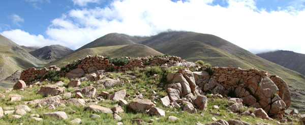
Fig. 13. The summit complex of Arpo Dzong from the north. The character and size of the remnants of this stronghold illustrate that it was a very well-built installation. Occupation by an elite and powerful social group is indicated.
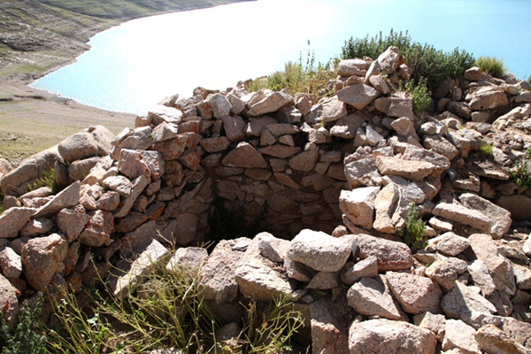
Fig. 14. Subterranean stone chambers in the summit complex of Arpo Dzong. These kinds of underground chambers are found in other archaic fastholds of Upper Tibet. The chambers pictured here were originally covered by an all-stone corbelled floor or roof.
Gyangpai Tsuk Dzong
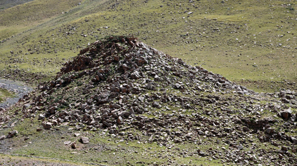
Fig. 15. The conical mount of Gyangpai Tsuk Dzong (4755 m elevation). The brownish zone on the left side (southeast) of the steep hill is comprised of scattered defensive walls.
Gyangpai Tsuk Dzong (rGyang-pa’i gtsug rdzong: ‘Walled Summit Fortress’) is situated on an eponymous conical mount south of Kyisum village. It is the largest of the village’s three fortresses, all of which are believed to date to the time of Zhang Zhung. Gyangpai Dzong occupies a strategic position overlooking a big bend in the route around Lake Dangra. The ruins of the ancient stronghold are found on the south and east sides of the rocky mount and on its summit. Like Arpo Dzong, Gyangpai Tsuk Dzong was an all-stone corbelled installation.
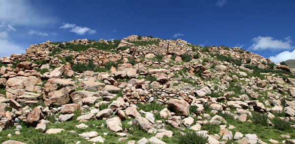
Fig. 16. The ruined granite structures blanketing the south side of the Gyampai Tsuk Dzong hill. The carcasses on this flank of the hill cover an area of approximately 1500 m². It appears that several tiers of buildings once clung to the hillside. There are virtually no standing walls left at the site: all structures have been reduced to footings and revetments.
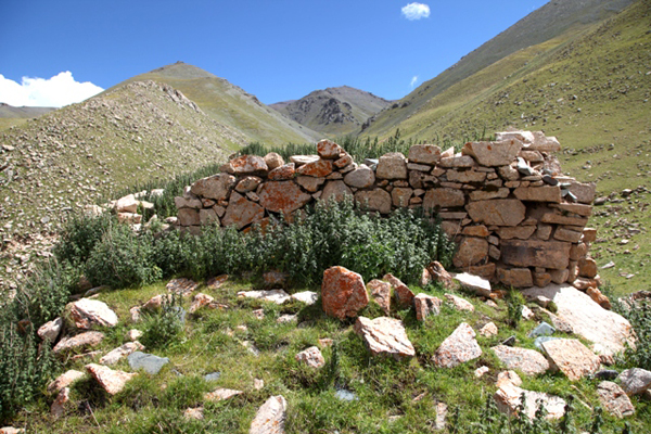
Fig. 17. The skillfully built random-rubble revetment on the west side of the summit, Gyangpai Tsuk Dzong. Note the orange climax lichen adhering to the stones.
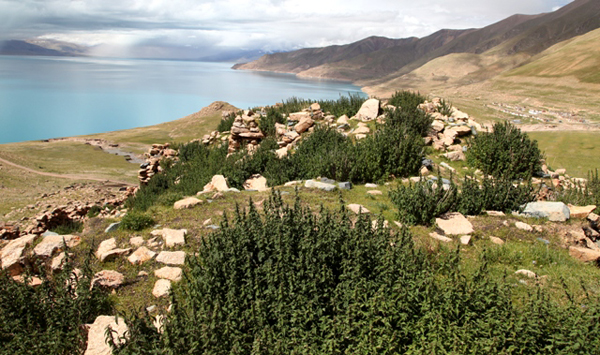
Fig. 18. The summit of Gyangpai Tsuk Dzong from the east. This summit measures approximately 31 m (east-west) x 7 m (north-south). It appears to have once hosted a dense array of buildings and to have been ringed by a defensive wall. Most of these structure were obliterated.
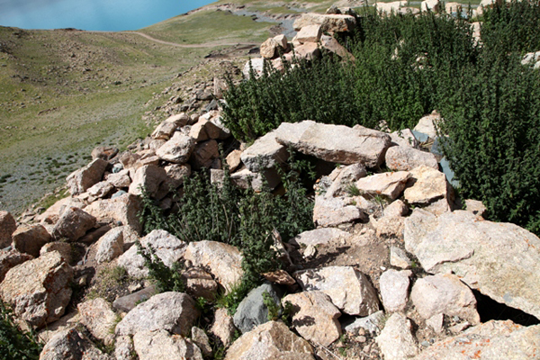
Fig. 19. Corbelled subterranean chambers on the west side of the summit, Gyangpai Tsuk Dzong. Also, on the east end of the summit, a single bridging stone spans a niche in a wall. Many structures on the summit are filled with earth and rubble.
The third ruined stronghold of Kyisum is Brakchung Utse Dzong (Brag-chung dbu-rtse rdzong: Summit Fort of the Little Formation). Located just outside the old village of Kyisum, very little of this installation have survived, precluding a clear assessment of its architectonic makeup. For a little more information on the three strongholds of Kyisum, see my book Antiquities of Northern Tibet.
Chuktsho Trokpo Dzong
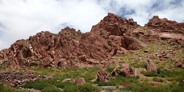
Fig. 20. The red rock formation of Chuktsho Trokpo Dzong (4740 m elevation). The ruins of an ancient fortress are found on the rocky backbone and extend for approximately 230 m along the northeast-southwest axis of of this formation. The maximum width of the summit and the dispersion of ruins is 70 m. No less than 50 buildings once stood at this site, potentially representing the residences of hundreds of people. In the foreground are stone pens for livestock, which are used for a short time each year by the drokpas of Lake Dangra.
Chuktsho Trokpo Dzong (Phyug-tsho grog-po rdzong: ‘Wealthy Federated Camps Ravine Fortress’), a sprawling ancient residential center, is also known as Gyangro Marseng (rGyang-ro dmar-seng: ‘Ruined Walls of the Red Lion’). It appears to have been the largest of Lake Dangra’s ten installations built on relatively unassailable summits. A stream (now intermittent) on the south side of the site called Gungthang Luchu (Gung-thang klu-chu) provided water for its inhabitants.
Chuktsho Trokpo Dzong is named for the the two ravines (grog-po) that flank it. Its alternative name, Gyangro Marseng is connected to a self-formed (rang-byon) lion believed to be found in the red rock formation of the site. A Tibetan source states that the Zhang Zhung-era saint Sene Gau was born at the foot of Drakphuk Namkechen (Brag-phug gnam-skas-can: ‘Rock Shelter with the Sky Stairs’), in Dangra Senge Dzong (‘Lion Fortress of Lake Dangra’; see Divine Dyads, p. 411). This Lion Fortress of Dangra is probably none other than the site now known as Chuktsho Trokpo Dzong / Gyangro Marseng. The ancient all-stone edifices of Upper Tibet, especially smaller ones, are often referred to as ‘rock shelters’ (brag-phug). The ‘sky-ladder’ or ‘sky-stairs’ (gnam-skas) appears to refer to one of the vertical rock formations at Chuktsho Trokpo Dzong. It is not unusual in Upper Tibetan lore for formations with special vertical markings or configurations to be perceived of as conduits to the heavens. That Sene Gau was born at the base of this kind of structure conveys that he would go on to achieve much greatness in the spiritual realm.
As I recorded in Divine Dyads, there is speculation among local elders that fortresses such as Chuktsho Drokpo Dzong may have remained viable until the 17th century CE, and the consolidation of Lake Dangra into the holdings of the Lhasa government during the reign of the Fifth Dalai Lama. However, there is very little archaeological evidence at Chuktsho Drokpo Dzong (or other fortresses) to substantiate this position. Nearly all of the structures of Chuktsho Drokpo Dzong are in an advanced state of ruin. As I now better appreciate, walls of 3 m or more in height are not uncommon in the ruined all-stone corbelled edifices of Upper Tibet. This type of structure is inherently strong and durable.
Nevertheless, the small corbelled residence located on the south side of the Chuktsho Drokpo Dzong rock formation featured in last month’s newsletter and another relatively well preserved example beside a nearby abandoned agricultural field, as well as several small mani walls with Buddhist mantras on a saddle in the same vicinity, are part of a more recent occupation of the Chuktsho Drokpo Dzong site. The entire east side of Lake Dangra remains a Bonpo stronghold. It would seem then that the mani stones were part of a Buddhist religious imposition. The most plausible agents of this intrusion into Bon ecclesiastic territory were the Sakyapa of the 13th century CE or the Jungar Mongols and their Gelukpa beneficiaries in the 17th century CE. The style of calligraphy and the highly eroded condition of the inscribed red sandstone plaques suggests to me the older of the two ruling entities is the more likely candidate. Be that as it may, one might speculate that Chuktsho Drokpo Dzong was reoccupied by a Buddhist-aligned political force in an act more symbolic than substantial. There is no obvious evidence for the wholesale renovation of Chuktsho Drokpo Dzong or of any other ancient fortress at Lake Dangra. In more recent times the site devolved to shepherds who remain its only contemporary users.
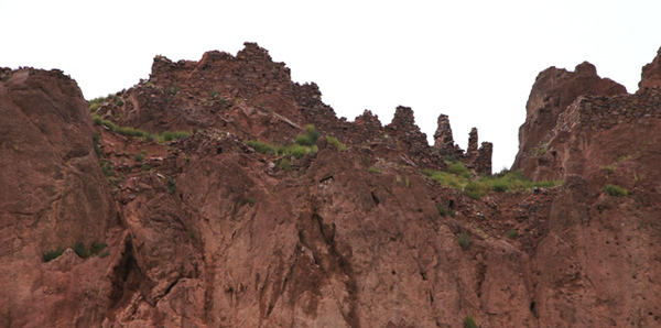
Fig. 21. The crumbling hulks of buildings on the summit of the Chuktsho Trokpo formation. Note the traces of defensive walls along the rim of the formation. Existing walls of the fortress reach 3 m to 4 m in height.
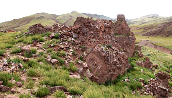
Fig. 22. The buildings of the central sector of Chuktsho Trokpo Dzong summit. The densest agglomeration of buildings is located in this sector (most of which cannot be seen in this photo). These all-stone corbelled structures were mainly constructed from roughly hewn pieces of tan and red sandstone. The walls are of a random-rubble fabric but there are also a few coursed-rubble types among them. The uppermost building on the right side is the only one on the summit to still have an intact stone roof. There are however a number of structures with in situ corbels. Note the parapet wall on the edge of the summit (middle right of image). Structures below the summit on the right (south) side of the formation are likely to have been defensive works.
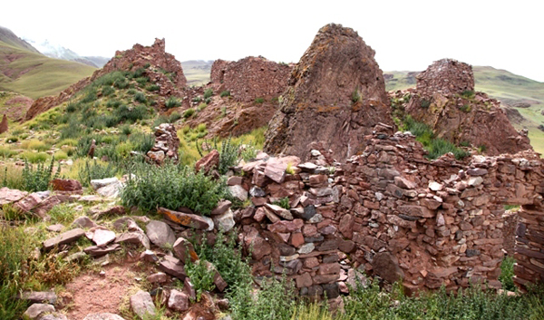
Fig. 23. Another view of the central sector of Chuktsho Trokpo Dzong looking toward the northeast. Note the entranceway with the in situ stone lintel in the bottom right corner. This entranceway measures 1.7 m x 70 cm, unusually large in this form of architecture prior to the 7th century CE. The large size of the portal may possibly be related to a particular prestigious function for this building. A corbel rests on top of the wall in the lower left portion of the image.
The diverse structures of Chuktsho Trokpo Dzong must have once housed a fully-operational, multifunctional settlement. The overall impression of the site is that it was once a prosperous and sophisticated hub of human habitation. As no evidence for archaic era villages has been found in the bottomlands around the contemporary villages, we can assume that the ancient population dwelled in and around the fortress and other high elevation facilities of Lake Dangra. Thus Chuktsho Trokpo Dzong might be better classed as a ‘fortified settlement’ to reflect ostensible functions beyond defense and the garrisoning of troops. Pastoralists of that time with their black yak hair tents would have been highly mobile as they are today, but permanent elements of the population gravitated to the protective embrace of the strongholds and the concealed locations of the ancient temples.
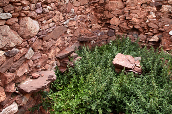
Fig. 24. One of several two-story-tall buildings at Chuktsho Trokpo Dzong. Note the line of heavy corbels demarcating the two floors. The stone joists that made up the second floor would have been supported by these corbels. There are not many sites in Upper Tibet with two-story all-stone corbelled structures. These kinds of edifices appear to have been reserved for larger and more affluent installations (see my Antiquities of Zhang Zhung, vol. 1, sites A-51, A-54, A-89, for other examples).
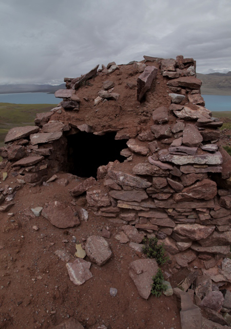
Fig. 25. The only structure at Chuktsho Trokpo Dzong with a partly intact stone roof. The single room of this structure only measures 2 m x 1.8 m. Given its lofty setting, it may have been a lookout post.
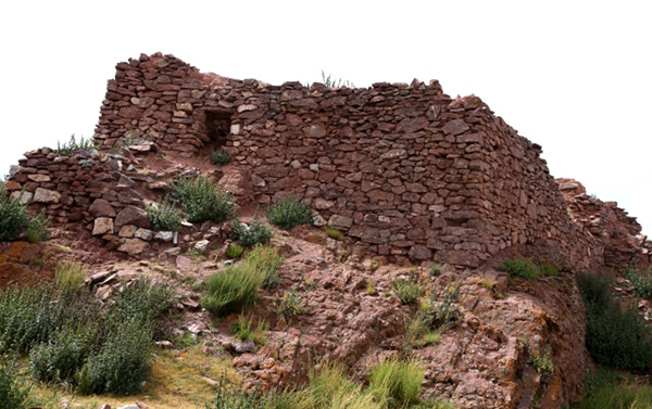
Fig. 26. Another ruined building with an intact entranceway. This diminutive entrance measures 1.1 m x 50 cm. Tiny portals are a characteristic feature of all-stone corbelled architecture in Upper Tibet, and this is especially so of structures built before the early historic period (650–1000 CE). Also, like the edifices of Chuktsho Trokpo Dzong, these buildings tend to be windowless.
Fig. 27. A large edifice of composite earthen and stone construction. Located in the east sector of Chuktsho Trokpo Dzong, this large structure possess unique architectonic features. Its size suggests a communal function, perhaps as a meeting hall or temple. This is borne out by the absence of internal partitions, save for a central wall bisecting the building. In order to span its widely spaced walls, this edifice must have had a roof made of wooden rafters.
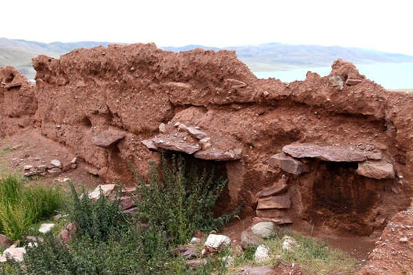
Fig. 28. The north wall of the structure in figure 27.
Embedded in this earthen wall are three sets of stone brackets, each comprised of a pair of corbels and a bridging stone. The bracket on the left has been reduced to just one corbel. The function of these massive stone brackets is not immediately apparent. A combination of structural value and internal space design seems indicated. This architectural feature has not been documented elsewhere. The earthen walls of this structure are highly eroded. They were either constructed with adobe blocks or rammed earth. Lines of stones at regular elevations in the wall may plug up orifices used to hold shuttering pins. If so, this indicates a rammed-earth composition. The exterior south wall and the central partition wall both have small portals complete with stone lintels. A thick stone wall was built to shore up the northwest corner of the building. That so much care was taken to preserve it seems to underscore a special value or purpose for the structure. There are also several smaller stone and earthen composite structures at Chuktsho Trokpo Dzong.
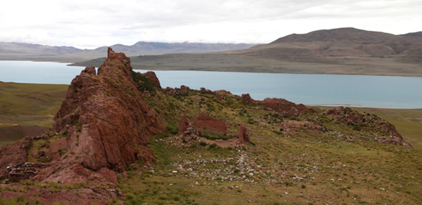
Fig. 29. View of Chuktsho Trokpo Dzong from the east. The composite edifice in figures 27 and 28 is visible in the middle foreground. It is part of the east sector of the fortress, a zone of more widely spaced structures. In the direction of the lake the wide central sector of the site with its many buildings is visible. The eastern portion of the Chuktsho Trokpo Dzong rock formation was not well developed. By leaving it mostly devoid of buildings the installation remains invisible until someone coming around the lake is nearly upon it. On the bottom left side of the image (south) the all-stone corbelled building featured in last month’s newsletter is visible.
Chuktsho Trokpo Gonpa
Fig. 30. Chuktsho Trokpo Gonpa as seen from Chuktsho Trokpo Dzong.
Approximately 500 m east of Chuktsho Drokpo Dzong is another ancient residential facility called Chuktsho Drokpo Gonpa (Phyug-tsho grog-po dgonpa: ‘Wealthy Federated Camps Ravine Monastery’). Chuktsho Drokpo Gonpa is situated on a high bench (elevation 4755 m) to the east of Chuktsho Drokpo Dzong. Unlike the fortress, it is flanked by higher slopes, giving it much less defensive cover. Moreover, there are no ramparts, parapets, high revetments or cliffs at the site. This topographical and architectural evidence suggests that Chuktsho Drokpo Gonpa was not primarily built for defensive purposes. Protection for the site would have come from the fortress in its shadow, Chuktsho Trokpo Dzong.
Chuktsho Trokpo Gonpa is reputed to have been a Zhang Zhung religious center, one of more than a dozen that are thought to grace the heights above Lake Dangra. While the age of the ruins are debatable, they could be those of a temple, palace, or other cultural facility. Its Zhang Zhung attribution in the oral tradition is possibly borne out by the all-stone corbelled structures of the site. In any case, these were founded before 1000 CE. Furthermore, an archaic cultural orientation, religious or otherwise, is supported by the absence of corresponding mani walls, chortens and other structures of obvious Lamaist persuasion at Chuktsho Trokpo Gonpa.
Chuktsho Trokpo Gonpa is comprised of a single complex of ruined buildings (24 m x 60 m). The structures are densely arrayed, save for an open area of around 14 m in length between the southern and northern halves of the complex. Most of the structures have been either effaced or leveled to their foundations, but there are also standing wall fragments. Architectonic evidence shows that most of the structures at Chuktsho Trokpo Gonpa possessed all-stone corbelled roofs. Among the ruined buildings there is a lone yellow sandstone pillar just 30 cm in height. The Tibetan letter A has been carved sideways on this pillar.
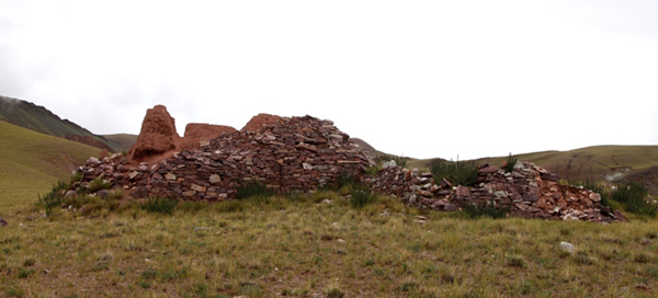
Fig. 31. Chuktsho Drokpo Dzong Gonpa from the west. Pictured is the largest remaining building (9 m x 7 m) at the site, situated on the northwest corner of the dispersion of ruins. Its west face consists of a stone and an earthen wall bonded together, which is up to 3 m in height, the tallest at the site.
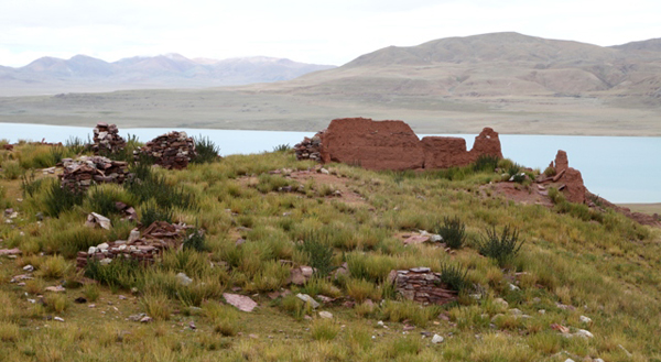
Fig. 32. The large edifice on the northwest side of the complex as seen from the east, Chuktsho Trokpo Gonpa. There is little structural evidence left with which to assess the character of this building, but what does remain suggests that it may have been a communal structure with commodious internal spaces.
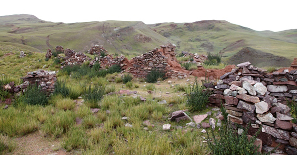
Fig. 33. Ruined stone structures of Chuktsho Trokpo Gonpa. Only highly fragmentary walls remain.
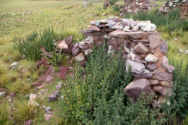
Fig. 34. One of the only ruins at Chuktsho Trokpo Gonpa to have retained intact roof appurtenances. A corbel juts out from the top of the wall in the upper right side of the image.
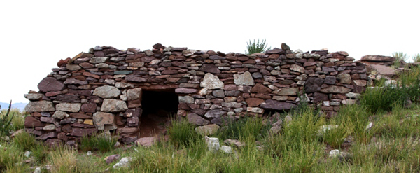
Fig. 35. A revetment on the east end of Chuktsho Trokpo Gonpa. This 1.5 m-tall wall has a deep recess on the exterior side topped by an all-stone roof. The long stone lintel over its entrance (1 m x 60 cm) is still intact. It is not at apparent what the functions of this chamber were.
On a prow to the east of the Chuktsho Trokpo Gonpa building complex are a couple of crudely built small shrines with a few prayers flags and a couple of stone plaques with inscribed prayers. These shrines are not an original feature of the site, however, they may have been built to replace older ones that were destroyed. That archaic shrines might once have been situated here is suggested by the prominent position overlooking Lake Dangra and the existence of a retaining wall built around the edge of the promontory. For more on Chuktsho Trokpo Gonpa and Chuktsho Trokpo Dzong, see Divine Dyads.
I hope you have enjoyed this trek across the sacred cultural-scape of Lake Dangra. In future issues of Flight of the Khyung, we will survey other ancient monuments in this cradle of Upper Tibetan civilization.
Next month: Another marker of ancient cosmopolitanism in the artifacts of Tibet and more!