February 2017
John Vincent Bellezza
Welcome to another Flight of the Khyung as we journey back in time and space to prehistoric Tibet! This newsletter explores two ancient necropolises discovered on the tablelands of western Tibet in 2010. These funerary sites consisting of temple-tombs and concourses of standing stones were briefly introduced to readers in the November 2010 newsletter. This month’s more detailed treatment follows the publication in these pages of another example of the same type of monument (December 2016 and January 2017 issues). Fear not, an article on an ancient retreat center in Upper Tibet announced last month will appear in the next issue.
The second feature in this newsletter reviews a recently published article on why wheat and barley replaced millets as the grain crops of choice on the Tibetan Plateau. In particular, I scrutinize a model developed by the authors to predict where barley 1n be grown in Tibet.
Stones of the Heavens: Two stelar necropolises discovered on the western Changthang
Introduction
Among thirty-one stelar necropolises distributed across much of Upper Tibet are two examples in the western Changthang discovered in 2010.* This work details findings of my reconnaissance mission to these sites along with a full complement of images. That expedition (Upper Tibetan Rock Art Expedition I) was supported by Joseph Optiker, an individual keenly interested in Tibetan history and religion. The writing of this article was made possible by a grant awarded me by the Shelley & Donald Rubin Foundation.
For a map of these thirty-one sites, see December 2016 Flight of the Khyung, fig. 4.
The morphology, function, chronology, geographic distribution and cross-cultural affinities of stelar necropolises are discussed in detail in the previous article featured in this newsletter and will not be revisited here. Readers are encouraged to consult that work for the wider cultural and technological context in which this highly distinctive type of funerary monument occurs.
Tshab Khag Doring
General site characteristics
A stelar necropolis called Tshab Khag Doring (Tshab-khag rdo-ring) is set in the middle of a broad plain at 4730 m elevation. The site is found some kilometers west of the small market town of Tshakha (Tshwa-kha), in what is now Gegye County (Dge-rgyas rdzong). This impressive ancient funerary monument was located with the aid of two local herders on July 15, 2010. The Tibetan spelling of the name and etymology of Tshab Khag Doring was not confirmed with other sources.
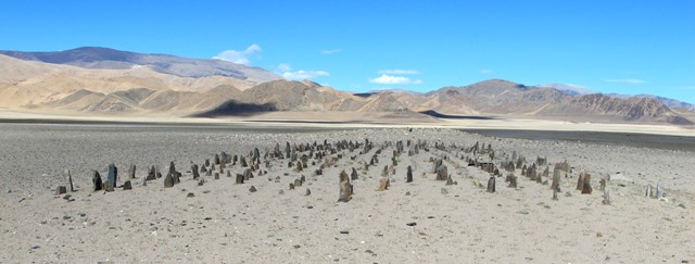
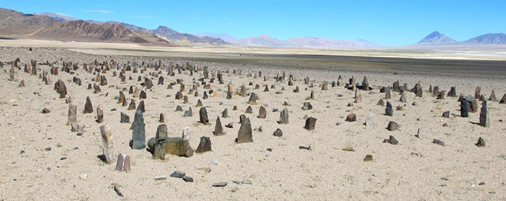
Fig. 1. The Tshab Khag Doring necropolis from the east. In the foreground is the array of stelae or pillars. In the background are the remains of the temple-tomb that is now nothing more than a rocky tumulus.
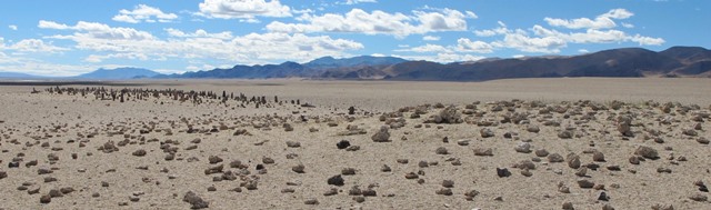
Fig. 2. Tshab Khag Doring viewed from the northwest. The gap between the extant standing stones (left side) and tumulus (right side) is a depressed portion of the concourse of stelae. The light-colored strip above the pillars on the extreme left side of the photograph is part of a string of alkaline lakes and flats in the bottom of the Tshakha basin.
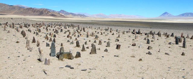
Fig. 3. Tshab Khag Doring from the southeast. The tallest stelae of the array are in the foreground. Note the very sandy terrain in this desiccated basin. However, there are freshwater streams and pasturage in sheltered valleys in the mountain range to the south.
There are unencumbered views in most directions from Tshab Khag Doring. To the south, approximately 3 km away, is the well-known rock art site of Kyildrum (Dkyil-sgrum). To the north is one of the salt lakes of Tshakha, a chain of highly alkaline bodies of water along the foot of a range of dusty mountains. A spur of the southern mountain range dividing the Tshakha basin from the region of Zhungpa (Gzhung-pa) encloses the west side of the plain some 10 km away. The most profound view is in the east and extends well beyond the settlement of Tshakha. The ground at Tshab Khag Doring is generally level, sandy and well drained. It appears that the formation of sand across the plain is the result of desertification over the centuries.
The array of pillars at Tshab Khag Doring is relatively intact, however, the temple-tomb appended to its west side has been nearly obliterated. That this was once a substantial aboveground structure with mortuary functions is confirmed by structural evidence from other stelar necropolises. There are a few uprooted pillars at Tshab Khag Doring but as of 2010, no signs of active vandalism.* There does not appear to be any contemporary religious usage of the site. Belonging to a cultural world largely alien to today’s inhabitants, most pre-Buddhist monuments in Upper Tibet are neglected and avoided.
Nevertheless, other archaeological sites in the vicinity have been damaged or destroyed in recent years. On the destruction of another stelar necropolis in the Tshakha basin, see the April 2015 Flight of the Khyung, fig. 8; Antiquities of Zhang Zhung, vol. 2:
http://www.thlib.org/bellezza/#!book=/bellezza2/wb/b2-1-25/
Array of stelae
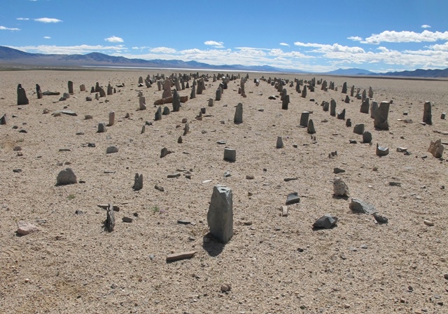
Fig. 4. The array of stelae viewed from the west. Note how the standing stones form even rows, which are aligned in the cardinal directions. More than half of the original number of stelae are now missing. In the background is the deep eastern vista, a characteristic spatial trait of stelar necropolises.
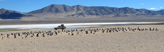
Fig. 5. The array of stelae seen from the south. In the central portion of the image is an alkaline lake and flats.
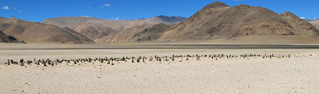
Fig. 6. The array of stelae from the north. Note the winter houses of local pastoralists on the edge of the mountain in the background.
As is common at stelar necropolises, the network of pillars or stelae and the temple-tomb at Tshab Khag Doring are aligned in the cardinal directions. The temple-tomb is in the west and the outward extremity of stelae is on the east end of the site. The array of standing stones measures at least 48 m (east-west) by 9–11 m (north-south). This array is elevated as much as 80 cm above the surrounding plain along its east and central portions. The west portion is now depressed below the level of adjoining terrain, the result of geomorphological changes to the site. This modification of the substrate may have contributed to the disappearance of stelae.
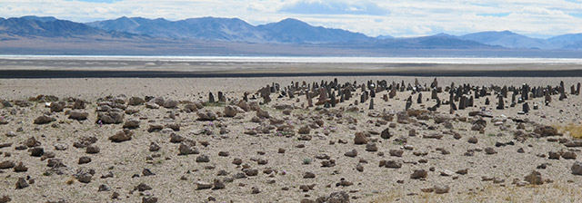
Fig. 7. The array of stelae as seen from over the top of the temple-tomb mound.
There appear to have been around 15 east-west running rows of stelae in the array, but many individual stones are missing. Approximately 560 stelae are still anchored in the ground, some of which are broken. There appear to have once been at least 1200 standing stones in the concourse. The stelae in each row are placed an average of 60 cm from one another, and each row is set 50 cm to 70 cm apart from the next one. In the central and eastern portions of the concourse, more than 50% of the stelae are still in situ. However, most stelae in the western portion of the array are missing. Standing stelae are situated 10 m or more east of the temple-tomb, but indications from other sites suggest that they once reached much closer to this edifice. Moreover, there are very few stelae in situ within 24 m of the temple-tomb.
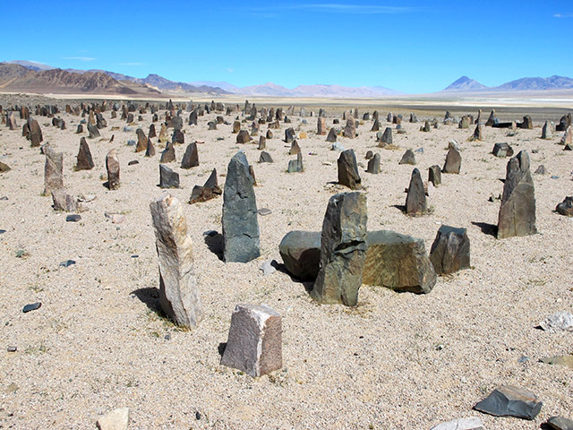
Fig. 8. The array of pillars head-on from the southeast corner.
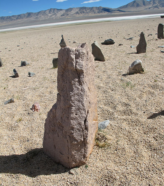
Fig. 9. Close-up of a stele in the central portion of the array of standing stones. Like other stelae in the array, this specimen was erected in its natural state without shaping.
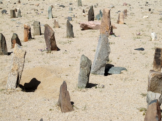
Fig. 10. Some of the multicolored stelae in the array of standing stones.
The stelae (can also be called pillars, menhirs or long-stones) are natural pieces of rock that protrude 10 cm to 40 cm above the ground surface. There are four intact stelae on the east end of the array reaching 50 cm in height, the tallest at the site. Mostly a fine-grained grayish and grayish green metamorphic rock with white speckles was used for erection. A variety of other types of rocks were also raised. These stones must have been quarried from mountains situated some kilometers from the site, requiring an efficient means of transportation (possibly horses or yaks were used). Standing stones having two broader faces were planted in the ground with these oriented north and south.
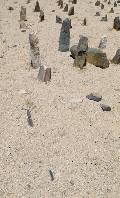
Fig. 11. Three small, dark-colored stones embedded in the ground, scant traces of a slab wall network situated immediately east of the array of stelae, can be seen on the lower left side of the image.
There is also evidence for a slab wall network east of the array of stelae, a common structural feature of stelar necropolises. Three dark-colored slabs embedded in the ground edgewise extend east from the southeast corner of the array of standing stones. These stones are each around 10 cm long and are now flush with the surface. They were part of an east-west aligned wall. A lone slab (15 cm long, protruding 5 cm above the surface) oriented north-south is found 4.8 m east of the southeast corner of the array. These slab wall remnants appear to mark the eastern extremity of the array of stelae. Other sections of slab walls in the vicinity are liable to be buried in the sands. Outlying funerary enclosures, including the superstructures of tombs, are visible at most stelar necropolises and there is no reason to believe that they did not also exist at Tshab Khag Doring. However, signs of such structures are not detectable on the surface. Ancillary elements were either destroyed or are concealed underground.
Temple-tomb
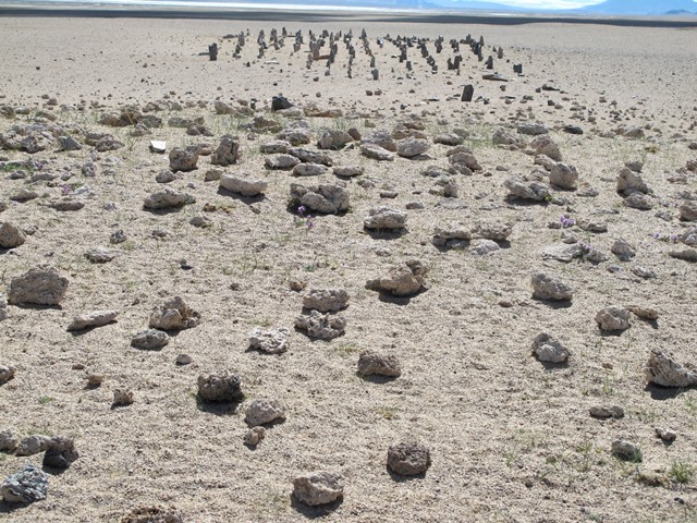
Fig. 12. The neatly ordered array of pillars as seen from the top of the remains of the temple-tomb (foreground).
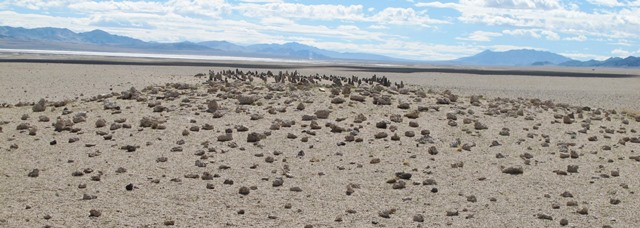
Fig. 13. The stone-studded mound (foreground), all that is visible of the temple-tomb, rises above the array of stelae. In the background is the vast eastern vista.
The temple-tomb, situated 10 m west of the most westerly stone still standing, measures approximately 9.4 m (north-south) by 5.2 m (east-west). Judging from similarly-sized but better-preserved examples at other sites, the temple-tomb at Tshab Khag Doring was a detached masonry structure at least 2 m in height. The erstwhile edifice sits on a patch of ground elevated around 1.2 m above the surrounding plain. It has been reduced to a sandy tumulus studded with white rocks and black rocks, 20 cm to 40 cm in length. These rocks probably formed distinctive structural elements of the temple-tomb. Nevertheless, harder and stronger stones like those used as pillars on the site may have formed the bulk of the edifice. Small fragments of the east wall footings of the temple-tomb have survived intact. These wall remnants are aligned in the cardinal directions and are around 65 cm in thickness. Milky quartz is scattered around the site and could have been used in monument construction or embellishment.
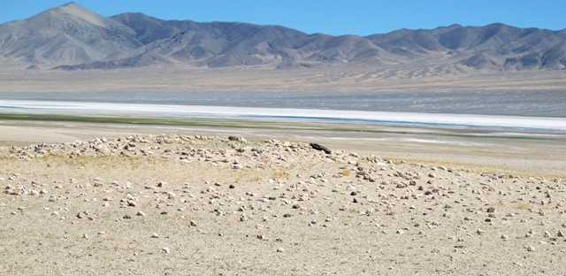
Fig. 14. The temple-tomb tumulus viewed from the south.
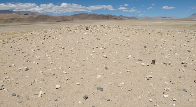
Fig. 15. The temple-tomb tumulus from the east.
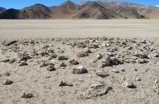
Fig. 16. The top of the temple-tomb mound seen from the northeast.
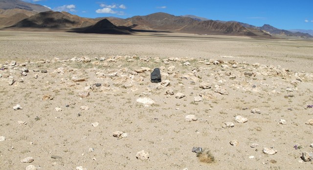
Fig. 17. All that remains of the temple-tomb is a rocky tumulus and scant traces of the east wall of the old masonry edifice. The dark stone in the middle of the mound appears to be one of the uprooted pillars.
The stelar necropolis at Thangde Mukyu
Introduction to the site
It was quite by accident that on July 16, 2010, I spied another stelar necropolis. Traveling by vehicle, I noticed pillars popping out of a rocky heap. It is rare to come upon a pre-Buddhist archaeological site in the vastness of the Changthang without guidance from local inhabitants. Subsequent inquiries confirmed that an isolated pyramidal outcrop situated approximately 350 m southeast of the site is called Thangde Mukyu (Thang-sde smug-yu).* However, no name or lore attached to the archaeological site was obtained locally.
Division of the Plain Reddish Brown Hornless Yak. The term yu-bo denotes livestock and wild ungulates without horns.
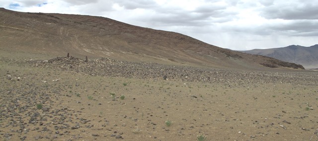
Fig. 18. The stelar necropolis near Thangde Mukyu viewed from the south. Note how the entire site is cloaked in rubble. Some of the small stelae or pillars of the array are visible in the middle of the photograph. Three mounds behind the rock strewn terrain are discernable. From left to right they are the temple-tomb (Mound I), companion structure (Mound II), and the most northeasterly structure at the site (Mound III). Like the temple-tomb, Mound II and Mound III appear to have been burial structures that stood conspicuously above the ground. The mountain range to the west seen in the photograph comes within 1 km of the site.
The stelar necropolis at Thangde Mukyu is in Tengtse (Steng-rtse), now a township of Gegye County (Dge-rgyas rdzong). However, Tengtse was traditionally part of the Ruthok District (Ru-thog rdzong). The site is situated at 4640 m in a relatively narrow valley drained by the Churi river (Chu-ris gtsang-po). As is typical of stelar necropolises, the most open vista is in the east, extending to a mountain range about 10 km away. The southern view is closed in by a range of mountains approximately 5 km from the site. Mountain ranges to the north and west are only around 1 km from the site. The Churi Tsangpo is about 400 m away and is set below a 10 m-high embankment that skirts the valley bottom. The terrain at the stelar necropolis is sandy and gently declines towards the southeast. Just 10 m southwest of the temple-tomb is a small outcrop of rock.
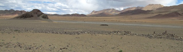
Fig. 19. The stelar necropolis viewed from the northwest. The temple-tomb studded with pillars and the companion structure (Mound II) are on the right side of the image. To their left is a rocky dispersion with remnants of structures. A mani wall with inscribed Buddhist plaques is in the middle of the image, while the pyramidal formation of Thangde Mukyu can be seen off to the left.
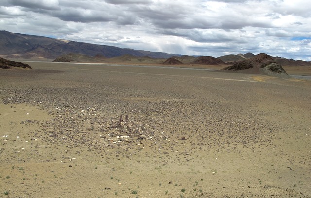
Fig. 20. The stelar necropolis viewed from the top of a small outcrop situated a few meters southwest of the site. The temple-tomb and array of stelae are in the foreground. Note how the terrain around these monuments is blanketed in rubble, much of which appears to have once been an integral part of the complex.
There are no signs of contemporary usage of the archaeological site. Approximately 100 m southeast of the stelar necropolis is an old mani wall, which was probably built with stones pilfered from the ancient structures. The mani wall may have been established to neutralize spiritual negativities perceived to emanate from the stelar necropolis. Untoward events are often ascribed to such sites by local residents. Approximately 30 m northwest of the temple-tomb is a sinuous wall roughly 50 m in length and minor dispersions consisting of sandstone blocks. These structures seem to constitute a derelict pastoral camp. The stones used to build it were probably extracted from the stelar necropolis as well.
General site characteristics
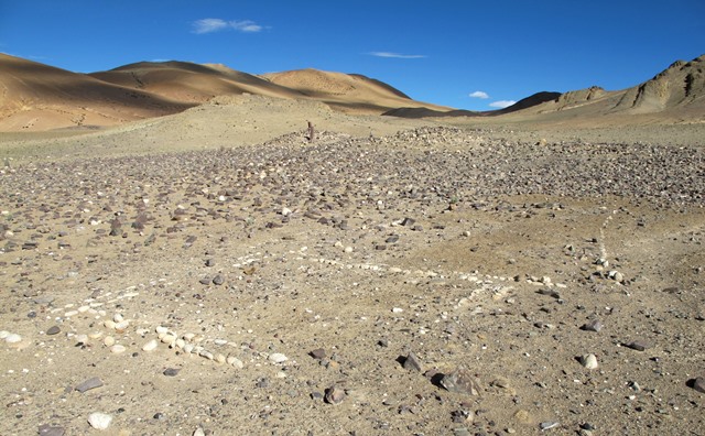
Fig. 21. The site from the northeast with white cobble enclosure in the foreground. Enclosures of various types at stelar necropolises were variously used for ritual and burial purposes. Note the light-colored natural outcrop situated 10 m southwest of the temple-tomb (mound with pillars sticking out).
The stelar necropolis at Thangde Mukyu contains a complex assortment of structural elements. In addition to an array of pillars and the appended temple-tomb, there are two other high-elevation structures on the site. These may possibly have been temple-tombs with their own arrays of standing stones but the remains are too degraded to determine their architecture. There are also enclosures and walls at ground level around the site. The sundry structures of the stelar necropolis at Thangde Mukpo constitute a uniquely designed funerary complex. In fact, all 31 stelar necropolises documented by the author in Upper Tibet are distinctive ensembles of structural elements, probably reflecting varying regional tastes, sociopolitical characteristics and economic capabilities. The morphological complexity of these funerary monuments mirrors the intricate belief system, ritual activities and technical sophistication of their builders and users.
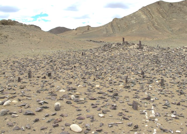
Fig. 22. The highly fragmentary array of pillars standing in front of the temple-tomb mound. The tall pillars on top of the mound are not original features of the site. Note the double-course cobble wall on the bottom right side of the image. The ritual and symbolic functions of the pillars and cobble wall have not been determined.
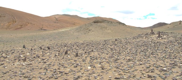
Fig. 23. The array of pillars and appended temple-tomb taken from the south.
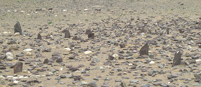
Fig. 24. A close-up of some of the still standing stones in the array.
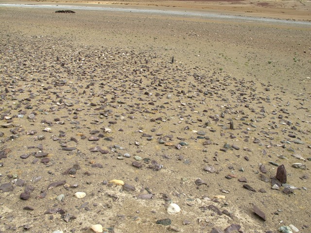
Fig. 25. The array of pillars from the top of the temple-tomb mound. In the background is the river known as Churi Tsangpo.
Array of stelae
The stelar necropolis at Thangde Mukyu is highly degraded. Only about fifty stelae or pillars remain standing and many of these are broken. This is probably less than 10% of the original number in the array. The pillars and appended-temple tomb are not aligned in the cardinal directions, but rather in the intermediate directions. The narrowness of the valley and attendant sighting constraints were perhaps a factor in their orientation. The extant array of stelae measures 14.8 m (northwest-southeast) by 7 m (northeast-southwest). It is not clear how large the array originally was nor how many rows of stelae there once were. There may possibly have been around twelve rows spaced approximately 60 cm apart from one another. Natural pieces of red, pink and gray sandstone were used as stelae. The surviving examples protrude 10 cm to 40 cm above ground level. The tallest intact specimen is planted near the southwest corner of the array.
Fig. 26. A wall consisting of two parallel courses of cobbles lodged in the ground, which cuts through the array of stelae and continues beyond its southeast extent. This type of wall did not support a superstructure, rather it appears to have had a peculiar ritualistic function. Double-course walls interspersed in a concourse of standing stones are quite common at stelar necropolises (they are often made of slabs set edgewise into the ground).
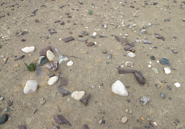
Fig. 27. Traces of a small enclosure located east of the cobble wall pictured in fig. 26.
In the southeast portion of the array of stelae is a double-course wall (5.2 m long) consisting of white igneous cobbles embedded in the ground. These cobbles are 5 cm to 15 cm long and rise slightly above the ground surface. They form a wall that runs northwest-southeast, 20 cm in thickness. This wall extends 3.5 m beyond the most southeasterly stelae in the array. A small enclosure (approximately 1.5 m across) is located 10.7 m east of the southeast terminus of the cobble wall. This structure is highly deteriorated and only the faint outline of the perimeter walls is discernable. Small, isolated quadrate enclosures are found east of some arrays of pillars at other stelar necropolises.
Temple-tomb
Fig. 28. The temple-tomb seen from the northwest. The pillars on top and to the left of the mound are not original structural features.
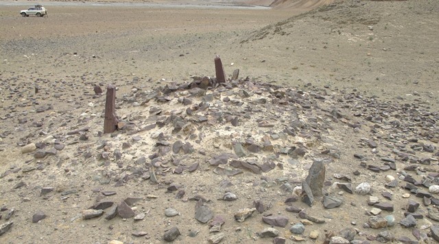
Fig. 29. The temple-tomb viewed from the northeast.
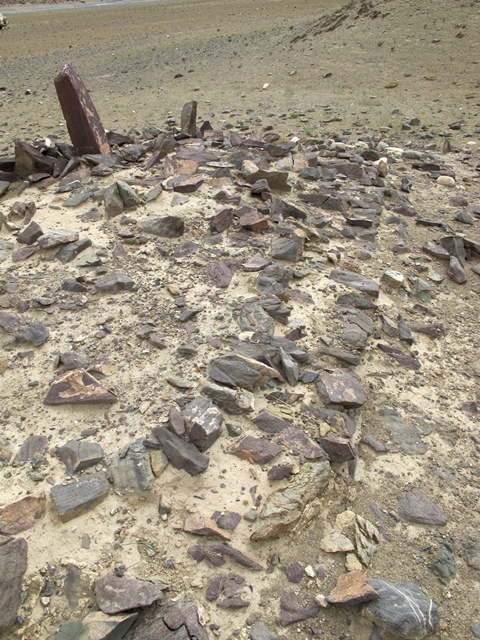
Fig. 30. The temple-tomb from the north. Note the double-course wall footing circumscribing the edge of the edifice. Although now heavily deteriorated, this well-built foundation must have supported free-standing walls 2 m or more in height.
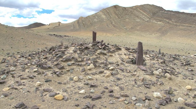
Fig. 31. The temple-tomb viewed from the south.
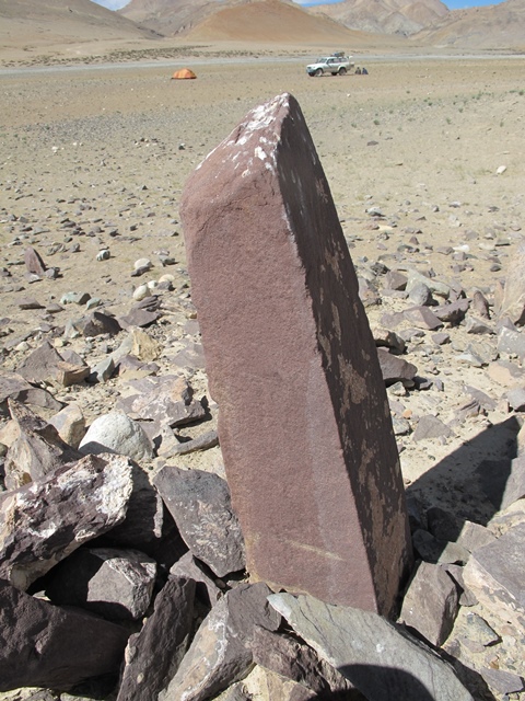
Fig. 32. A close-up of one of the red sandstone pillars erected atop the temple-tomb mound. Although the pillar itself appears to be ancient, its current placement is a later modification to the site. The author’s camp is in the background.
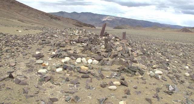
Fig. 33. The southwest side of the temple-tomb. Note the coherent wall fragments at the base of the structure.
The temple-tomb (Mound I) is situated 2.5 m northwest of the closest stele in the array. This highly degraded edifice is now not much more than a rocky mound. It measures 6.4 m (northeast-southwest) by 4 m (southeast-northwest). Fragments of wall footings have survived. These are 55 cm to 60 cm in thickness and are composed of white cobbles (15–25 cm long) and sandstone blocks (10–40 cm long). The footings are best preserved on the northwest and southwest sides but also exist on the northeast side of the structure. The temple-tomb mound is 80 cm high on its northwest side and 1.5 m high on its southeast side, but there are no extant freestanding wall sections. The difference in height of the two sides of the mound is accounted for by the slope gradient. Three sandstone pillars were firmly planted on top of the temple-tomb mound for unknown reasons sometime in the past. The tallest specimen protrudes 90 cm from the surface, indicating that larger stelae were used at the site.
Other tumuli and adjacent structures
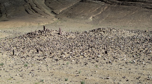
Fig. 34. The temple-tomb (mound on left), concourse of standing stones (foreground) and companion structure (mound on right).
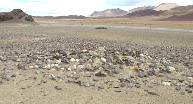
Fig. 35. Companion structure (Mound II) located 3 m east of the temple-tomb as viewed from the northwest.
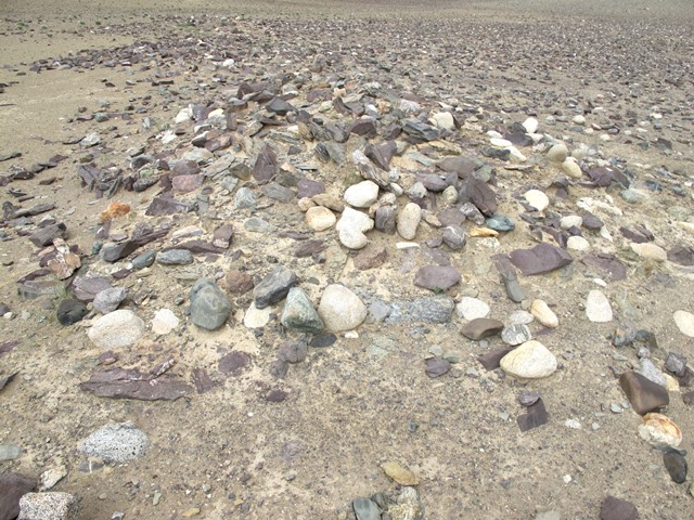
Fig. 36. Mound II viewed from the southwest.
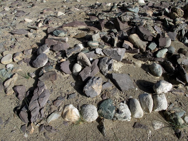
Fig. 37. Traces of coherent wall footings on the north corner of Mound II. These kinds of footings typically underpinned freestanding masonry walls.
A structure (Mound II) of similar appearance, size and aspect to the temple-tomb is located 3 m east of it. However, Mound II is so degraded that an appraisal of its original morphological characteristics is not possible. It measures 5.4 m (northeast-southwest) by 4 m (southeast-northwest). Now mostly an amorphous rocky tumulus, this structure is elevated 80 cm on its northwest flank and 1.5 m on its southeast side. Nevertheless, small fragments of wall footings of the same type as the temple-tomb are extant. These are composed of stones 15 cm to 30 cm in length. There are no stelae visible on the rubble-strewn ground southeast of Mound II. This seems to indicate that the structure differed somewhat in function from the adjacent temple-tomb.* Two small pillars made of an igneous rock were erected between the temple-tomb and Mound II. The placement of these stones does not appear to be an original structural feature of the site.
The pairing of an elaborate enclosure with a temple-tomb is found at Ganglung Doring (Gangs-lung rdo-ring); see Antiquities of Zhang Zhung, vol. 2, pp. 75–78:
http://www.thlib.org/bellezza/#!book=/bellezza2/wb/b2-1-39/
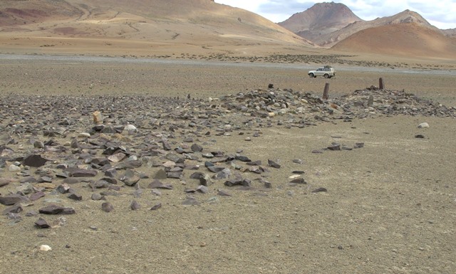
Fig. 38. Mound I (extreme right), Mound II (middle right) and adjacent rocky dispersions to the north (left side).
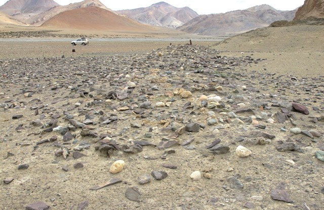
Fig. 39. The most northeasterly structure (Mound III) at Thangde Mukyu in the foreground and the temple-tomb (Mound I) and companion structure (Mound II) in the background.
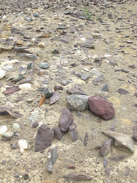
Fig. 40. A coherent wall footing on the northwest side of Mound III. This double-course footing (60–70 cm thick) would have supported a freestanding wall, suggesting that a significant masonry edifice once stood here.
Adjacent to Mound II is a rocky dispersion (14 m x 4.2 m) that extends to the northeast. Only the faintest traces of walls are discernable in this blanket of rubble and these are concentrated in the southwest half of the dispersion. A large stone near the southwest corner of the dispersion protrudes 40 cm above the ground surface. Adjoining this rock-strewn area in the northwest is another rocky dispersion (3.5 m x 5 m). Perhaps this is the remains of a funerary enclosure. Immediately northeast of the larger dispersion is another structure (Mound III), measuring 10.8 m (southwest-northeast) by 4.2 m (northwest-southeast). The forward (southeast) side of Mound III rises 80 cm above the surrounding terrain while the rear (northwest) side is elevated 20 cm. Fragments of wall footings are visible on the northwest side of Mound III, indicating that substantial walls once stood here. The wall footings are primarily composed of uncut sandstone blocks up to 30 cm in length.
Mound III, the most northeasterly structure at the site, is in line with the temple-tomb (Mound I), companion structure (Mound II) and the intervening large dispersion. They form a single row of structures oriented northeast-southwest and are situated at the same elevation. What appear to be three small stelae in situ are in line with the northeast wall of Mound III, 8.4 m to 11.5 m southeast of its east corner. A small pillar is also located southeast of the juncture between Mound II and the large dispersion to its northeast. This pillar is found 3.5 m southwest of a cobble wall network (see below). These isolated and hard-to-recognize standing stones may possibly be vestiges of other arrays of stelae at the site.
Cobble wall network
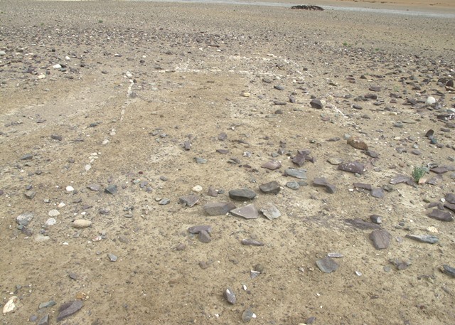
Fig. 41. Two single-course cobble walls (foreground) and double-course cobble wall enclosure (background), as viewed from the northwest. The dark-colored structure in the background is a mani wall.
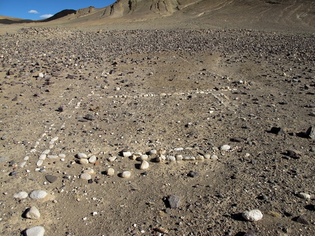
Fig. 42. Single-course walls and double-course cobble wall enclosure pictured in fig. 41, as seen from the southeast. Note how the east corner of the double-course enclosure is absent. The tumulus in the upper left corner of the image is Mound II.
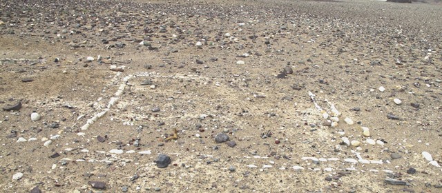
Fig. 43. The double-course cobble wall enclosure viewed from the southwest. Part of the parallel single-course cobble walls are visible on the left side of the image. Note how most cobbles jut out from the ground, creating clearly demarcated structures. These walls did not support permanent superstructures.
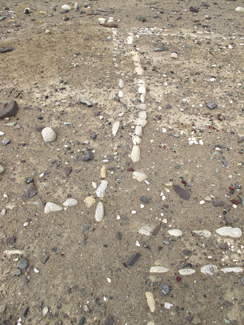
Fig. 44. A close-up of the double-course enclosure with various extensions of the perimeter walls beyond the form of a simple square. These collateral wall segments hint at the existence of a more elaborate network of cobble wall structures at the site in the past.
Southeast of Mound III and the large dispersion of rubble next to it are a series of cobble walls crisscrossing part of the site. Like other structures of the stelar necropolis, these walls are oriented in the intermediate directions, producing a spatially coherent monumental and ritual space. Two main structures among the cobble walls are discernable. One of these consists of two parallel walls beginning 16.5 m southeast of the large dispersion. These walls are 7 m in length (running northwest-southeast) and spaced 3.7 m apart. If there were once southeast and northwest walls as well forming a full enclosure, these have disappeared. The two extant walls are comprised of single courses of white cobbles embedded in the ground. Near the southeast end of the southwest wall, there are two or three other single-course cobble walls running parallel. These walls are highly fragmentary and around 1.7 m in length.
A square enclosure with a double-course cobble wall perimeter begins 1.5 m southeast of the single-course cobble walls. These double-course cobble walls are around 25 cm thick and composed of white igneous rocks (5–15 cm long). Each of the four perimeter walls of the enclosure is about 3.4 m in length. However, they do not neatly join each other; rather they are cut short or extend past the bounds of a perfect square. From this evidence, it can be assumed that the configuration of cobble walls at the site was once more intricate.
Conclusion
As we have seen, the stelar necropolis at Thangde Mukyu contains a diverse group of structures. These include one or more concourses of stelae (each appended to a temple-tomb or other edifice), a network of cobble walls and superficial enclosures. Yet, so much about this stelar necropolis remains enigmatic. ‘When was this funerary site founded and how long was it used’, ‘which of its elements had a burial function and which were ritualistic in nature’, and ‘what was the character of the sociopolitical provision supporting it’ are a few major questions that immediately come to mind. Only through further research and exploration will answers to these and other questions be won.
A Review of a Recently Published Article: “A 5500 Year Model of Changing Crop Niches on the Tibetan Plateau”
This review examines an article presenting an agricultural thermal niche model that predicts the altitudinal distribution of staple grains on the Tibetan Plateau over the last 5500 years. See d’Alpoim Guedes, Jade / Manning, Sturt W. / Bocinsky, R. Kyle: 2016: “A 5500 Year Model of Changing Crop Niches on the Tibetan Plateau”, in Current Anthropology, vol. 57 (no. 4). Chicago: University of Chicago Press.
This work furnishes a critical discussion of predictions made by the agricultural thermal niche model devised by d’Alpoim Guedes et al. The approach I use is of course dictated by my own area of expertise. An archaeobotanist, dendrochronologist, paleoclimatologist, computational archaeologist or specialist in radiocarbon dating doing a review of the same article might well focus on other aspects of the study including technical questions pertaining to the formulation of the model.
The thesis of the d’Alpoim Guedes et al. article is that cultivation of barley and wheat permitted agriculture to thrive on the Tibetan Plateau when the growing of millet was no longer feasible, because of a cooling of the climate some 3500 years ago. The article also discusses how climatic conditions on the Tibetan Plateau from 5500 BCE until the present favored specific niches for agriculture comprised of lower elevation river valleys. The authors relate altitudinal constraints to the ancient practice of agriculture on the Tibetan Plateau to current patterns of barley cultivation on the Tibetan Plateau. They do not, however, equate ancient and contemporary niches of barley cultivation with one another, as these may have varied considerably over time.
The d’Alpoim Guedes et al. article begins by enunciating an archaeological axiom, one that unfortunately is sometimes still overlooked: the presence of plant domesticates at a site does not necessarily mean they were cultivated there. Yet, as I shall demonstrate, this axiom and the evidence provided by d’Alpoim Guedes et al. does not diminish an assertion made in two recent reports cited regarding how agriculture might have contributed to the permanent human occupation on the Tibetan Plateau (Chen et al. 2015; Dong et al. 2015).* These two works maintain that barley cultivation was routinely brought to areas above 4000 m.†
Claims made in Chen et al. 2015 that an agropastoral way of life introduced after circa 1700 BCE was responsible for the permanent habitation of much of the Tibetan Plateau cannot be sustained in light of more recent studies. More on this crucial subject in next month’s Flight of the Khyung.
See F. H. Chen / G. H. Dong / D. J. Zhang / X. Y. Liu / X. Jia / C. B. An / M. M. Ma / Y. W. Xie / L. Barton / X. Y. Ren / Z. J. Zhao / X. H. Wu / M. K. Jones. 2015: “Agriculture facilitated permanent human occupation of the Tibetan Plateau after 3600 B.P.”, in Science, vol. 347 (issue 6219), pp. 248–250+supplement. The claim made in Chen et al. 2015 that barley cultivation was brought to elevations above 4000 m is categorically rejected in a rebuttal that appeared in the same journal: d’Alpoim Guedes, J. /Bocinsky, R. K. / Butler, E. E. 2015: “Comment on “Agriculture facilitated permanent human occupation of the Tibetan Plateau after 3600 B.P. ””, in Science vol. 348 (issue 6237), p. 872b. That the model used by d’Alpiom et al. does not take into account the full range of parameters necessary to accurately predict the full distribution of cropland on the Tibetan Plateau, as barley is cultivated up to 4750 m in elevation, is noted in a rebuttal by Dong et al. 2015. This work suggests that genetic variability and agricultural practice may possibly account for the cultivation of barley above 4000 m. As Dong et al. state, barley is grown by thousands of Tibetan farmers in various regions at elevations exceeding 4000 m. See Dong, Guanghui / Zhang, Dongju / Liu, Xinyi / Liu, Fengwen / Chen, Fahu / Jones, Martin. 2015: “Response to Comment on “Agriculture facilitated permanent human occupation of the Tibetan Plateau after 3600 B.P.”, in Science, vol. 348 (issue 6237), p. 872c.
The d’Alpoim Guedes et al. article does a fine job of summarizing data concerning the transition from millet cultivation to that of wheat and barley. They cite studies (including their own) to illustrate how for 2000 years, foxtail and broomcorn millets were the primary grain crops in Eastern Tibet before being replaced around 1500 BCE by two newly introduced domesticates, wheat and barley. As the authors note, an understanding of where and when such crops were grown is crucial in assessing how the Tibetan economy evolved, including the emerging relationship between agriculturalists and pastoralists.
The authors’ fig. 2 charts the probability of millet cultivation between 3000 and 4200 years ago, showing a downward altitudinal trend from 3000 m to 2000 m, in a period corresponding with increasing cold and a reduction in East Asian summer monsoon intensity. The authors of the paper also observe how after a period of interregional exchanges between northwest China and the southeastern Tibetan Plateau (SETP), ceramic finds suggest that these were curtailed after ca. 2500 BCE. However, ca. 2000 BCE with the introduction of wheat and barley cultivation in eastern Tibet, interactions between the northeastern Tibetan Plateau (NETP) and the SETP intensified. This appears to correspond with a new suite of cultural traits aligned with cultures of the extreme northeast (Kayue, Siwa, Xindian, etc.) penetrating far to the south. These observations nicely square with the archaeological record as we know it. The authors suggest that although wheat and barley were introduced to East Asia around 4500 ago, they were probably minor or traded crops until around 1500 BCE. They believe that Tibetan farmers continued growing more familiar millet until decreasing yields and crop failure encouraged experimentation with wheat and barley.
d’Alpoim Guedes et al. observe that agriculture on the SETP may have been abandoned because of a time gap discerned in the archaeological record between a decline in millet cultivation and the introduction of wheat and barley. Further exploration and research should be carried out to verify that there was indeed a gap in domesticates cultivated on the SETP 4500–4000 years ago. In any case, this does not imply that the SETP was emptied of people. In such a vast and environmentally diverse region, a wide spectrum of economic subsistence strategies is likely to have been in operation, maximizing the human occupancy and cultural potential of the region.
The authors maintain that genetic adaptations of barley to high altitudes in Eurasia may possibly be related to the development of a spring phenotype (facilitated barley cultivation northward and eastward from the Near East into regions with colder winters). Yet, the authors also state it is likely that short season, cold-resistant strains of barley were developed by Tibetan farmers in response to a sharp cooling of the climate in just the last 1000 years. More research is required to determine if rapid maturation (grain filling) adaptations in the barley genome are really this late. This is a pressing question, especially considering the authors’ own observation that strong genetic links exist between Tibetan wild barley and Tibetan naked barleys, a hybridization that probably improved the cold tolerance of cultivated varieties.
Fig. 1 of d’Alpoim Guedes et al reveals that all ancient agricultural sites considered by the authors, radiocarbon dated and undated, are restricted to Eastern Tibet (regions of Khams and Amdo, a list of these sites is provided in their supplement). Only around Chamdo do these sites extend into the so-called Tibet Autonomous Region, a territory of 1.23 million km². Hardly any dating of early agricultural sites in Central Tibet and Western Tibet has been conducted.*
On the dating of such sites, see d’Alpoim Guedes, A. / Lu, Hongliang / Li, Yongxian Li, Spengler, R. N. / Wu, Xiaohong / Aldenderfer, M. S. 2014: “Moving agriculture onto the Tibetan plateau: The archaeobotanical evidence”, in Archaeological and Anthropological Sciences, vol. 6, pp. 255–269.
The d’Alpoim Guedes et al. study holds that like today, Tibetan farmers in the past grew crops only in deeply cut, lower elevation river valleys of the Tibetan Plateau, almost all situated below 4000 m asl. (above mean sea level). The authors believe that agriculture could not advance to higher regions, putting much of the Tibetan Plateau out of reach to farmers. They state that 99.98% of contemporary cropland in Tibet is found below 4000 m. One reason that an exceedingly small percentage of agriculture is computed to be above 4000 m is that the authors define the lower margin of the Tibetan Plateau at just 1500 m elevation, extending its territory into other physiographic provinces including the Tsaidam Basin and Loess valleys of the upper Yellow River basin. Nevertheless, data used by the authors to determine that only 0.02% of agriculture occurs above 4000 m appears to be of insufficient precision.*
The sources of this statistic are given in supplementary materials attached to the authors’ article: “CA1 Supplement A” from d’Alpoim Guedes et al., “A 5,500-Year Model of Changing Crop Niches on the Tibetan Plateau””, in Current Anthropology, vol. 57, no. 4, p. 517. This supplement is subtitled: “Methods: Contemporary Agriculture on the Tibetan Plateau”. The authors state that in order to model the geographical and altitudinal distribution of agriculture on the Tibetan Plateau, they relied upon the Global Land Cover–SHARE Cropland database version 1.0 (GLC-SHARE), which was created by the Food and Agriculture Organization (Latham et al. 2014; available at http://www.glcn.org/databases/lc_glcshare_en.jsp). The GLC-SHARE database is supposed to provide a picture of cropland on the Tibetan Plateau down to a 30-arc-second (approximately 1-km) spatial resolution. Yet, the map generated from the GLC-SHARE dataset by Lantham et al. 2014 seems to designate too little cropland cover (appear as raster cells on map) in Central Tibet and Western Tibet (see fig. A1). Data derived from the GLC-SHARE database was overlaid on an one-arc-minute resolution global relief model of elevation (Amante and Eakins 2009; available at http://www.ngdc.noaa.gov/mgg/global/). As this DEM model was an overlay only, it is not likely to have had an adverse effect on the authors’ computations.
The discussion of altitudinal limits to barley cultivation in present-day Tibet that follows is based on my own extensive but anecdotal field observations and reference to topographical maps.* This methodology does not produce highly accurate findings, however, discrepancies between my figures for cropland distribution in Tibet and those of d’Alpoim Guedes et al. are so large as to furnish an ample margin of error. Formal geographical and agronomic study is of course needed to produce a reliable and comprehensive picture of contemporary croplands on the Tibetan Plateau.
Technical Pilotage Charts, 1:500,000; Joint Operation Graphics, 1:250,000; Soviet General Staff, 1:200,000.
My findings contradict those of d’Alpoim Guedes et al. that cropland in Tibet, except for the tiniest patches (0.02% of the total), does not exceed 4000 m asl. Although it is true though that in most regions of Eastern Tibet and Kongpo (region in the southeast portion of the TAR) agriculture is not practiced above 4000 m, throughout Central Tibet (U-Tsang) and Western Tibet (Changthang and Tö) cultivation of barley consistently occurs above 4000 m. I estimate that 15–20% of cropland in east Central Tibet (U), 20–25% in west Central Tibet (Tsang) and 25–30% in Western Tibet occur at elevations exceeding 4000 m. I estimate that 70–80% of present-day cropland in Central Tibet and Western Tibet is situated above 3300 m elevation.
In many major valley systems of east Central Tibet, barley growing reaches 4000–4250 m in elevation. This is also true for many major valley systems in west Central Tibet, both south and north of the Brahmaputra River (Yarlung Tsangpo). The capitol of Tsang, Shigtase, is situated at 3800 m and its second city, Gyantse, is at 3980 m. Many agriculture villages in upper valleys surrounding these cities are situated above 4000 m elevation. Around Lhatse (4040 m), Tsang’s third city and another very large barley growing area, there are numerous agricultural valleys set at a higher elevation. For example, in the more than 100 km-long Me valley, barley plots are situated upwards of 4450 m above sea level.* A comparable elevation for barley cultivation is achieved in the Tingri and Ngamring regions to the west. Higher elevation barley cultivation (around 4600 m) is found in the Men Chu valley and on the east shore of Lake Peikü further west. In some far western Tibet districts (Gar and Ruthok) barley growing commonly extends to 4350 m. In the Guge and Purang districts of far western Tibet, barley is also grown in certain places up to 4300–4350 m (in Khyunglung and Montsher). In Spiti (India), on the western fringe of the Tibetan Plateau, barley is cultivated up to 4400 m above sea level. The highest altitude barley growing enclave in Tibet is located on the east shore of Lake Dangra, in the middle of the interminable tablelands of the Changthang. Here barley thrives in a string of villages high above the lake at 4580 m to 4740 m in elevation.
Dong et al. 2015 report that barley was grown at Lake Yamdrok (in U) and Sakya (in Tsang) above 4400 m in historical times. Barley is still grown in these regions today, as I know from my own travels.
Fig. 45. Barley being cultivated at Ganglung, a village rising above the waters of Lake Dangra (4535 m asl.) on the Northern Plains (Changthang). At 4700 m in height, this represents the highest elevation agriculture in the world.
Eastern Tibet, Central Tibet and Western Tibet constitute distinctive physiographic provinces, each with its own climatic, geological, hydrological and ecological regime. In Central and Western Tibet, valleys tend to be higher and broader than in Eastern Tibet. These regions also possess varying degrees of continentality or removal from oceanic effects moderating climate. The increased degree of continentality, as defined by a greater mean annual temperature range from east to west on the Tibetan Plateau, has a positive correlation with altitudinal limits to barley cultivation (latitudinal range of most of the Tibetan Plateau does not appear to be a pivotal factor in determining altitudinal constraints to cropland, as it is the same for the SETP, Central Tibet and Western Tibet).* On the Tibetan Plateau greater continentality results in higher warm season temperatures and longer growing seasons above 4000 m in the central and western regions. Central Tibet is more continental than eastern Tibet because of the Himalayan barrier which blocks most atmospheric moisture generated by the Indian Ocean. Agriculture extends in Central Tibet to 4500 m. Continentality is even more pronounced in Western (Upper) Tibet, the aridest portion of the Tibetan Plateau and the one with the greatest seasonal temperature variability. As noted, barley cultivation occurs here at even higher elevations, reaching above 4700 m.
Even in the NETP, Dong et al. 2015 report that in the early 20th century barley was cultivated at Jyekundo (Yushu) above 4200 m elevation.
d’Alpoim Guedes et al. do not describe the geographic character of the western half of the Tibetan Plateau. They state, “Tibetan farmers in the past, as today, practiced agriculture in deeply cut lower-altitude river valleys on the Tibetan Plateau”. This characterization pertains to much of eastern Tibet with its alpine biomes and montane forests. Central Tibet and Western Tibet, generally higher regions of the Tibetan Plateau, are progressively drier (from east to west) and dominated by steppe forests, scrub and grasslands (there are also alpine grasslands, tundra and deserts).
Long stretches of the Brahmaputra valley are devoid of cultivation of any kind. At least in part, this is because of extreme desiccation, precipitated by a lack of vegetation cover and almost constant exposure to high winds. A case in point is the famous Samye valley in U; barley cultivation stops 10 km upstream in a relatively verdant, climatically more equable and partially afforested tributary valley. The confluence with the Brahmaputra valley (and many other locations along this big river valley) resembles a desert, complete with sand dunes. It is a highly exposed environment with extreme atmospheric and soil moisture fluctuations: arid and by turns very hot and cold. Most arable lands in the Brahmaputra valley drainage system are concentrated on alluvial fans in the mouth of side valleys and higher up in side valleys. At many sites agriculture is practiced on plateaus, benches and slopes with much solar exposure and elevated well above valley bottoms. These observations about the Brahmaputra valley are also valid for the Indus river valley in far western Tibet: barley cultivation is mostly concentrated in tributary valleys.
Although a variable mix of climatic factors is implicated, a comparable regime of increasing aridity and continentality is also seen in cis-Himalayan and Transhimlayan regions of India. For example, on the south side of the Outer Himalaya, in the Indian state of Himachal Pradesh, barley cultivation occurs up to 2250 m. On the south side of the Great Himalayan Range in the district of Lahoul barley growing extends to 3300 m and in Transhimalayan tracts of Himachal Pradesh barley is grown to a height of 4400 m.
In addition to significant biogeographical differences and variations in continentality from east to west on the Tibetan Plateau, other major geographic factors potentially influencing the limits of barley cultivation are mountain-mass effect (temperature related phenomenon of higher snowlines and tree-lines in the interior portion of mountain ranges) and aspect (physical and biotic effects caused by the direction a slope faces).* Only by pursuing quantitative approaches that take into consideration both continentality and altitude and possibly other factors as well can an agricultural thermal niche model be developed, one that accurately and consistently predicts upward limits to agriculture and barley cultivation across the Tibetan Plateau. Moreover, empirical validation is crucial, the cross-checking of results obtained from models with facts on the ground. The d’Alpoim Guedes et al. study would have also benefited from an augmented cultural perspective on Tibet, giving barley cultivation a real-life face.
d’Alpoim Guedes et al. acknowledge that temperature inversions and cold-air flows down valleys might affect cropland distribution; however, they do not attempt to factor these microclimatic effects into their model because of insufficient meteorological data for the Tibetan Plateau.
The d’Alpoim Guedes et al. study examined in this review is a useful guide for appreciating the changing profile of plant domesticates on the Tibetan Plateau. Like other scientific papers that have appeared in the last decade, this work helps fill in holes in our knowledge of prehistoric Tibet. Unfortunately, progress in that direction is proving slow and fitful.
Next Month: More exciting exploration in Upper Tibet!