
June 2012
John Vincent Bellezza
This month’s Flight of the Khyung brings you to another fortified settlement in Guge, the great badlands region of western Tibet. This archaeological site was first documented on the Upper Tibet Rock Art Expedition II (UTRAE II), in 2011. Guge is surely one of the most fascinating regions in Tibet in terms of its natural and cultural history. If you want to get an idea of how rugged this Transhimalayan district is, take a piece of paper, crumble it in your hands, and see the result. Guge harbors hundreds of deep canyons (up to 2200 m in depth). I have been systematically exploring these canyons for many years. As much as I have seen, it would probably take an entire lifetime to thoroughly chart all the ruins in this one corner of western Tibet.
Regiment Valley
There are more than 25 locations in Guge that were once thriving agricultural lands connected to troglodytic settlements and hilltop strongholds, which are now utterly abandoned. Many other Guge sites present only cave complexes and fallow ground. This latter group of sites does not appear in my published surveys of early archaeological monuments. An even greater number of locations in Guge have cave complexes constituting the original nuclei of settlement, but which underwent subsequent development. Beginning around 1000 CE, monasteries, temples and houses came up at many Guge sites where previously the population appears to have resided exclusively in caves. In this category are well-known places such as Dunkar (Dung-dkar), Chiwang (Phyi-dbang), Bedongpo (Bral gdong-po), Sangdarjo (Sangs-dar jo), Shangtse Khar (Shangs-rtse mkhar), and Dapa (Mda’-pa). As these locations are still loci of contemporary settlement (save for Sangs-dar jo), much of their ancient character has disappeared with time. Fields have been recut, houses rebuilt, and new roads and irrigation projects established, obscuring from view earlier manmade structures.
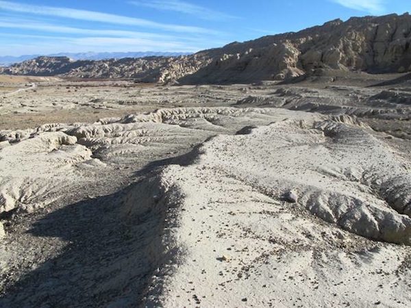
Fig. 1. A view of some of the defunct agricultural terraces at Regiment Valley.
More valuable than redeveloped residential sites, especially for field surveys relying mainly on a visual appraisal, are places that were discarded long ago. Often left untouched for centuries they stand as mute testament to a more populous past in Guge’s history. An excellent case in point is a desolate stretch of valley over a pass from Mda’-pa, in Guge Lhome. For our purposes we will call this site Regiment Valley, as its Tibetan name is not easily translatable. Here at 4160 m in elevation there is unmistakable evidence of past agriculture. Covering an area of roughly 700 m by 400 m, are bermed terraces made up of light-colored, thick and very fine soil. Beside these defunct fields there is a wide flood plain but these days the stream running through it is usually a mere trickle. It seems very likely that the diminution of this watercourse contributed to the abandonment of farming in Regiment Valley. Above the bulk of fields, a thin strip of old farmland extends for many hundreds of meters along what was once the main irrigation canal. Although it is largely filled in, the contour of the land along which the life-giving water once flowed can be followed to the edge of the flood plain.
The fields of Regiment Valley are cut by deep gullies formed by water running off the adjoining hills. There are ruined chortens on the opposite side of the valley and in a canyon adjacent to the site, but no Buddhist monuments in Regiment Valley itself. This and other evidence we shall examine suggests that this locale had been sidelined by the time of the Buddhist renaissance in the late 10th and 11th centuries CE, a time when chorten complexes were built at many dozens of locations in Guge.
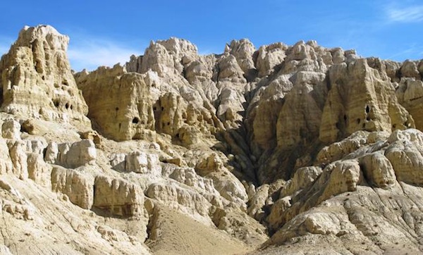
Fig. 2. The cave complexes sandwiched between the fields and castle. These are artificially created grottoes typical of Guge. A series of wooden gangways and ladders may have been used to access the caves from above.
Towering above the ancient farms of Regiment Valley are the structures in which the inhabitants once resided. In the head of the canyon east of the fields there are around 30 caves perched approximately 100 m up. These caves appear to have been accessed from above. They are no longer reachable. The caves occupy a position in the vertical escarpment that would have been easy to defend against attackers. Moreover, they had the benefit of being situated directly below a fortress. Nowadays there is only one way up to this fortress and the going is steep and exposed. This exploration is not suited for those suffering from acrophobia!
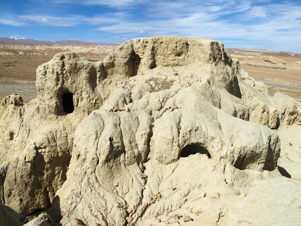
Fig. 3. The forward bastion, which guarded access to all of the Regiment Valley residential installations. In the background a couple snowy peaks of the Great Himalaya Range can just be made out.
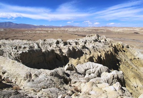
Fig. 4. The 130 m-long eastern spur. The forward bastion is visible on the right side of the spur.
The Regiment Valley stronghold (it does not have a local name) consists of several interconnected ridgelines littered with caves and crumbling walls. It is centered above a long valley directly overlooking the defunct fields. The site commands excellent views over the vast countryside. A natural rampart 5 m in height barricades the forward section of the fortress from the lower approach. This appears to have been the only access point to the Regiment Valley fortress and cave complexes, an ideal defensive arrangement.
The fortress was cut from the earthen formation, but where the manmade walls end and the natural formations begin is sometimes difficult to determine due to extreme erosion. There are also cobble, sandstone and adobe wall fragments but very little structural evidence has survived intact.
The bastion (40 m x 25 m) is found on the edge of the eastern spur (4275 m). It consists of wall traces and 12 caves, all of which were modified in the traditional manner with domed recesses in the rear flanked by oblong niches. In the 90 m-section of the eastern spur north of the bastion, there are the faint remains of a few other caves.
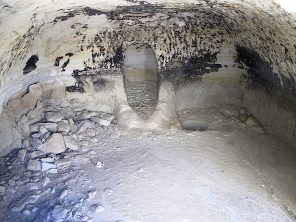
Fig. 5. A typical cave of Regiment Valley and of all Guge. Note the deep central recess in the rear of the cave. Sometimes adobe hearths are found in front of this sui generis feature. Also note the fire-blackened walls. Caves such as this one were clearly occupied for significant periods of time. In ostensible archaic sites like Regiment Valley, very little of the soot depositions remain adhering to the ceiling. In caves occupied during the Buddhist era, this soot often forms a thick, well agglutinated layer on ceilings.
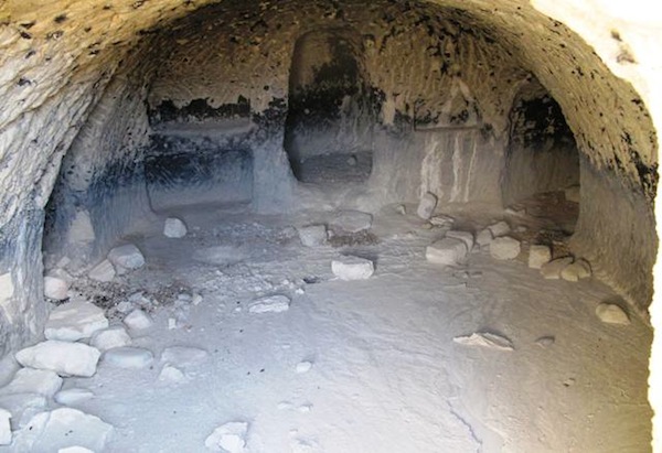
Fig. 6. A large cave with ancillary chambers (in side walls), central recess and oblong niches. Note the way in which these excavated features were scored in order to augment their structural integrity. This scoring helped prevent the earthen walls from cleaving and crumbling.
Where the eastern spur connects to the summit of the badlands formation there is another complex of around one dozen caves. These caves had adobe-block, cobble and sandstone fronts, but these structures are in a state of advanced degradation. One large cave (5 m x 3.8 m) has two sizeable ancillary chambers and a rear recess 1.2 m deep. There are also many oblong niches in its walls. This was a fairly elaborate residence, which like other caves at Regiment Valley remained cool in the summer and afforded protection from the winds and chill of winter. There is also a cave with tshwa tshwa, the Buddhist votive offering clay plaques used throughout Tibet. These tshwa tshwa must have been deposited to symbolically bring the Regiment Valley fortress into the fold of Buddhism. To the east of this cave complex there appears to have been a route that passes behind the summit, which accessed the 30 odd caves of the eastern canyon.
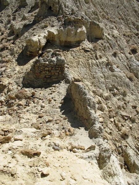
Fig. 7. Stone and adobe wall fragments of the central spur.
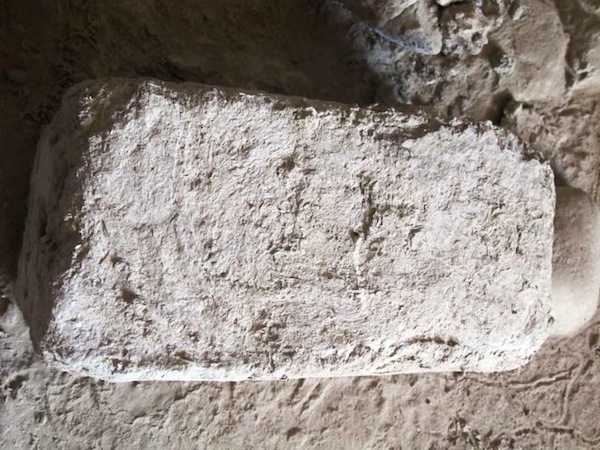
Fig. 8. An intact mud brick (34 cm x 16 cm x 12 cm) found inside a cave of the central spur.
The eastern spur connects to the summit ridgeline; it also appears to have had a few caves as well as structures made of cobbles. Traversing the steep, highly eroded slopes of the summit ridge for 60 m, one arrives at the smaller central spur (4290 m). The central spur (26 m x 6 m) hosted a dense collection of structures cut from the formation and freestanding walls built from cobbles and sandstone slabs. Underneath this building complex are two caves, one of which has a stone slab roof. Inside this cave (4 m x 3 m) are several adobe blocks. These unbaked mud bricks appear to be much harder than those used in contemporary construction in the region. They are also lighter in color, an indication possibly that they contain clay. Organic matter trapped in these bricks could possibly hold a key for dating the Regiment Valley stronghold, but this is a project for future efforts.
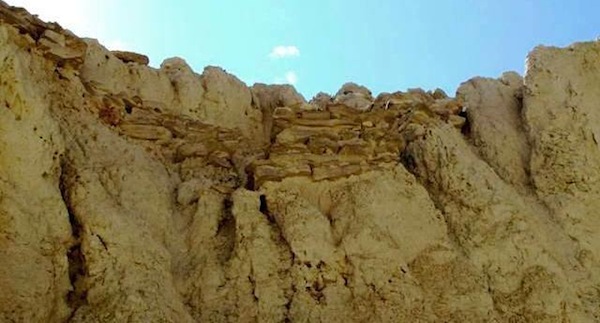
Fig. 9. A sandstone slab wall fragment embedded into the summit complex (4310 m). This type of wall is often associated with the archaic fortresses of Guge.
There is also a western spur connected to the summit ridge of Regiment Valley but it was not visited during the UTRAE II. It appears to host around six highly degraded caves. On the summit above the central spur is another residential complex (22 m x 7 m). A number of sandstone wall fragments are embedded in the formation here.
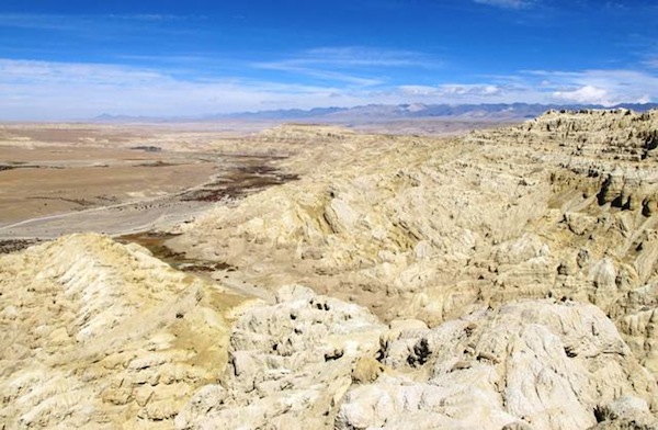
Fig. 10. Looking north from the central spur. The western spur can be seen in the foreground. In the distance is the Transhimalayan A-yi-la Range.
The Regiment Valley fortress appears to have been of middling size, as regards the ancient residential facilities of Guge. In addition to the standing masonry structures, there were at least 75 caves at the site. To put its size in perspective there are number of sites in Guge with hundreds of ancient caves, and Phyi-dbang has around 3000! Perhaps several hundred people once lived at Regiment Valley but probably no more than that. By contrast, according to local legend, 1000 people once resided on the inner side (village side) of the Phyi-dbang formation and 1000 people in the caves of its outer side.
The extreme deterioration of Regiment Valley habitations indicates that they are of significant antiquity. The lack of Buddhist emblems save for the ad hoc deposition of tshwa tshwa suggests a pre-Buddhist or archaic attribution. This is also indicated by the exceptional defensive posture of the site, its lofty aspect, and the lack of an oral tradition (Buddhist sites in the area are clearly recognized as such by local residents). Moreover, the cobble and sandstone wall fabric of the site is a trait of the so-called Mon or Bskal-mon castles of Guge, another indication that the Regiment Valley fortress was one link in a long chain of archaic agricultural citadels. Given this evidence we can probably conclude that this monument was established no later than the early historic period (650–1000 CE). It could of course be much older than that. I would not be surprised if it was. A Metal Age date for the regiment Valley fortress’ founding makes better sense in climatic terms, as water then appears to have been more plentiful and human settlement more extensive than in early historic times. Desiccation in Guge is yet another scientific study that needs to be undertaken, if we are to learn more about the rise and fall of civilization in the region. Now that this interesting site has been documented, it will hopefully spur on more exploration. At least we now have a start in the right direction!
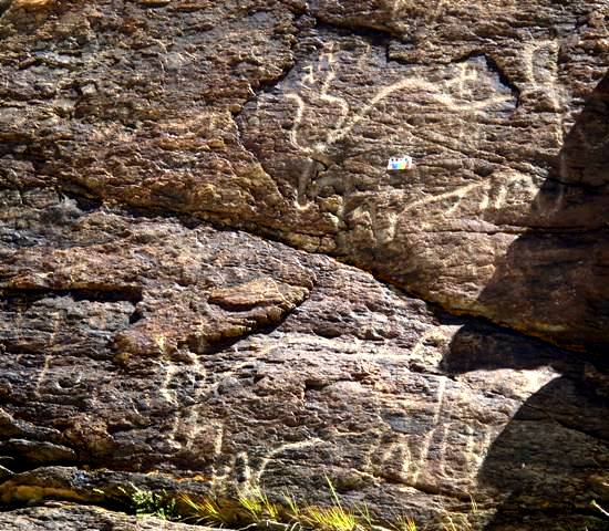
Fig. 11. The largest yak rock art documented to date in Upper Tibet.
This rock art site at the foot of the A-yi-la Range in Guge was first documented by Li Yongxian of Sichuan University. I reached this site on the UTRAE II. The lower yak petroglyph is 1.6 m in length, the upper specimen 1.45 m in length. There is a third smaller yak not seen in this image. Located on a long outcrop on the upper edge of a huge esplanade, this must have been a prime wild yak hunting ground at one time. The rocks here would have offered hunters the ability to conceal themselves from their prey. In close proximity to the yaks are a number of counterclockwise swastikas. According to local folklore, the three carved yaks at this auspicious site represent a father and mother and their calf. As might be expected, it is the upper yak with its large withers that is considered the bull. An examination of the physical characteristics of the various swastikas indicates that they were engraved in different periods (a particularly large one is found just to the left of the lower yak). While it is not obvious from this image (it has been digitally manipulated to increase the contrast), the yaks are quite heavily re-patinated. Their style (fan-shaped tails, double curved horns, broad rectangular bodies, etc.) appears to be a product of the Iron Age, but this remains to be confirmed. As to the art’s original function or purpose, we can only speculate. One possible hypothesis is that the carvings were used in the propitiation of yaks during hunting rites. The swastikas only add to the auspiciousness of the rock art and the site in general.
Next month: The oldest gods of Tibet!