
May 2012
John Vincent Bellezza
May’s Flight of the Khyung takes you to another forgotten bastion of civilization in uppermost Tibet. This gigantic citadel was documented for the first time in 2011, one of several dozen archaic strongholds found in western Tibet. It goes to show you how much there still is to discover on the Roof of the World. And it is only in this newsletter that can be a party to it!
The exploration of the great Sutlej River Valley Citadel
On the Upper Tibet Rock Art Expedition II, I finally reached a destination in my sights for over a decade. I first heard of Sutlej River Valley Citadel (a sobriquet) in 2000, but was repeatedly prevented from reaching it due to high water. This impressive archaeological site, located in the Guge district of western Tibet (Ngari), consists of a large stronghold sitting atop a rocky eminence. There is also a village of smaller residences, a line of recently looted chortens, and a lower complex of buildings. Where many hundreds of people once lived there is now not a single soul. The site was completely vacated before living memory. According to the oral tradition of the region, the castle here was ruled over by a figure called Darkam Pawo (Dpa’-bo = Hero).
A large shelf rises above the north bank of the Sutlej River upon which stands a craggy mount. On top and on the upper flanks of this naturally protected hill are the circumvallating ramparts and well-constructed buildings belonging to the fortress. The imposing Sutlej River Valley Citadel is located not so far downstream from Khyunglung (Horned-eagle Valley) village. In ancient times, this stretch of the valley may possibly have been known as Khyunglung as well. At present, there is no way to ascertain if Sutlej River Valley citadel corresponds to one of the three Zhang Zhung castles that existed in Khyunglung, according to Bon literary sources. There are other ruined strongholds in the vicinity. It appears that Sutlej River Valley Citadel stood guard over a key river crossing connecting the two territorial halves of Guge. The sheer size and geographic placement of the facility points to it as having been of considerable regional importance.

Fig. 1. The great Sutlej River Valley Citadel photographed from the opposite side of the river. The tall ramparts surrounding the ancient installation are visible, as are a few old residences and the line of chortens at the foot of the mount.
On the precipitous slopes below the citadel extending as far down as the foot of the hill are the remains of 14 domiciles. Most of these residences as well as the buildings of the citadel itself are of an all-stone corbelled composition. This archaic style of construction may have arisen in Upper Tibet as early as the first half of the first millennium BCE. The corbelled architecture of the region appears to have a long history, with buildings possibly being made in this fashion as late as the 10th century CE (for more information on the chronology of all-stone corbelled architecture in Upper Tibet, see the books Antiquities of Upper Tibet and Zhang Zhung, and the website thlib.org/bellezza).
The founding date of Sutlej River Valley Citadel remains to be determined. Nevertheless, an early historic period (650–1000 CE) establishment may be indicated for at least some of the ruins, given their mix of architectonic specifications. In addition to all-stone corbelled structures, there are high, straight stone walls in the facility; these could only have supported roofs built with wooden timbers. The existence of stone and wooden roofs in integrally created buildings may signal a historic era chronology.
Sutlej River Valley Citadel appears to have enjoyed various phases of construction and habitation. Except for a line of ruined chortens at the base of the citadel mount, there are no recognizable Buddhist monuments at the site. These chortens were built of adobe blocks. Their method of construction and style suggest that they were added to the site circa 1000–1200 CE. The chortens were planted well away from the residential structures, hinting that they belonged to disparate religious orientations. With the rise of the Guge-Purang kingdom at the end of the 10th century CE, numerous residential sites were redeveloped in Guge as Buddhist monasteries, temples and retreats. Nonetheless, many other ancient sites were never intensively reoccupied and made do with arrays of Buddhist ceremonial monuments. Typically, only chortens and mani walls came up at locations generally overlooked for permanent residency. The erection of ceremonial monuments functioned to bring older places of habitation ritually and symbolically into the Buddhist ambit. That no Buddhist temples appeared at Sutlej River Valley Citadel strongly suggests that it was already in decline by the dawn of the second millennium CE. Had it been otherwise, such a large and strategically important center would surely have supported a more elaborate Buddhist infrastructure (as was the case at many dozens of other Guge sites). This is not to say, however, that Sutlej River Valley Citadel was totally abandoned in the Buddhist era. Travelers and shepherds at minimum would have passed through it, as they still do from time to time.
That Sutlej River Valley Citadel underwent different phases of construction is also indicated in the reconstruction of two stone lintels using tamarisk (?) timbers. Small rounds of wood from both of these lintels were extracted for radiocarbon analysis. This work was undertaken by the well-known Beta Analytic lab (Miami) and was generously funded by the Tibetan Medical Foundation (Weslaco). The assayed timbers date to circa 1450 to 1600 CE; their chronometric parameters very closely aligned with one another. One of the composite lintels is found in the largest structure of Sector IV of the citadel, the other in the highest of individual residences situated just below the ramparts. The wooden additions are rudimentary in nature and out of character with the high quality masonry fabric of the site. We might infer from the acquired chronometric data that buildings of Sutlej River Valley Citadel were being used as late as 1600 CE, but only marginally so. This may have been an occupation comprising a relatively small group of farmers rather than a sociopolitical elite (analogous to the one that constructed the stronghold). In any event, the shelf below the citadel was once intensively cultivated. Depopulation and desiccation in the region, probably in tandem with one another, spelt the end to agriculture at Sutlej River Valley Citadel. When farming at the site was halted (or for that matter when it began) is not yet known.
.")
Fig. 2. The Sutlej River Valley and defunct agricultural zone below the citadel. There is no longer a perennial source of water in the two gorges flanking the citadel mount. The berms and terraces of the erstwhile fields are still clearly discernible. These former arable lands with their thick, loamy soil are spread over an area of approximately 600 m x 500 m. In all probability, barley was once cultivated here, irrigated with water that came from the western gorge (right side of image).
Another possible sign of different phases of construction at Sutlej River Valley Citadel is the village of small houses. These are built outside the protective embrace of the fortress, leaving them vulnerable to any hostile incursion. I suspect that they appeared in a strategic environment different from the one in which the hilltop installation was first established. This altered strategic world may have occurred with the unification of the Tibetan Plateau under King Songtsen Gampo, in the 7th century CE. During the imperial period, regional rivalries were dampened by a conquest-driven military machine controlled by the emperors (btsan-po). In contrast, in the protohistoric period (100 BCE–650 CE), localized defense was a huge preoccupation, with virtually every agricultural enclave in western Tibet having been reinforced with a hilltop safehold. Perhaps therefore the first phase of construction at Sutlej River Valley Citadel dates to this more remote epoch.
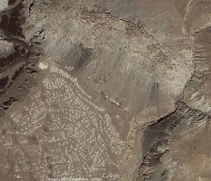
Satellite image of the Sutlej River Citadel (top of image). The defunct agricultural lands are in the lower left half of the image.
Sutlej River Valley Citadel in figures and photos
The summit of Sutlej River Valley Citadel is situated at 4175 m elevation. Along its east-west axis, the installation is 202 m in length, and contains a dense collection of buildings. These structures were primarily built of blue and tan sandstone slabs and blocks. Sutlej River Valley Citadel walls are generally 30 cm to 60 cm thick, some of which were built of thin slabs of stone 10 cm to 30 cm in length. I have divided this once mighty stronghold into five sectors :
Sector I (11.3 m x 11.5 m): The lowest and narrowest portion of the citadel, which overlooks the eastern gorge. Contained around 12 buildings and rooms of various sizes.
Sector II (14.5 m x 27 m): Contained around 23 buildings and rooms.
Sector III (44 m x 40.5 m): Contained around 30 buildings and rooms.
Sector IV (46 m x 25 m): The highest portion of the summit. Walls in this sector reach a maximum of 5.7 m in height, the tallest at the site. Contained at least 42 buildings and rooms.
Sector V (48 m x 16 m). Situated on the west end of the summit. Contained approximately 39 buildings and rooms.
, a highly unusual structural material. This type of wall could only have supported a lighter roof made of wooden members.")
Fig. 3. A view to the east overlooking the ruins in sectors IV and V of the citadel. Note the light-colored clay-based mortar used in the seams of the walls. There is also a longitudinal upper wall segment made of this same material (right foreground), a highly unusual structural material. This type of wall could only have supported a lighter roof made of wooden members.

Fig. 4. The sprawling citadel from the southeast. Not much more than half of this once very substantial installation is visible in the photograph.
 with a stone lintel. This may have been the egress of a latrine pit.")
Fig. 5. The building with the tallest walls in Sector IV of the citadel, situated on the highest portion of the summit. Like other buildings at the site, the random-rubble slab walls were very adeptly built. In the forward portion of this two-story structure is an opening (approximately 1.2 m in height) with a stone lintel. This may have been the egress of a latrine pit.
 connecting two rooms in Sector I. This is one of the only entrances that remains intact in the ruined facility. The lintel (1 m long) has broken in half. Above it is an aperture (35 cm x 30 cm) with its own lintel. Doorways are typically small in the all-stone corbelled architecture of Upper Tibet. Much of the clay-based plaster is still affixed to the walls.")
Fig. 6. An entranceway (90 cm x 60 cm) connecting two rooms in Sector I. This is one of the only entrances that remains intact in the ruined facility. The lintel (1 m long) has broken in half. Above it is an aperture (35 cm x 30 cm) with its own lintel. Doorways are typically small in the all-stone corbelled architecture of Upper Tibet. Much of the clay-based plaster is still affixed to the walls.

Fig. 7. An intact bridging stone in the north wall of Sector II. In the wall below there is a niche, one of many found in the interior walls of the citadel.

Fig. 8. A structure almost entirely engulfed by rubble in Sector III. Two large corbels are still in situ, signalling that this was an all-stone corbelled edifice. Also note the curvature in the rear wall of the structure, another trait of this type of architecture. The rear wall was set deeply into the steep slope, which must have given the building a semi-subterranean aspect. It is common in Upper Tibet to find this kind of structure built partially underground.

Fig. 9. Portion of a stone slab floor in Sector III. There is a shallow cavity underneath the stone flooring. This construction is but one indication of the great care and skill that went into building Sutlej River Valley Citadel. Its construction was underwritten by a powerful economic order, like the one explored in last month’s newsletter.
. The smaller broken round of wood in the foreground was extracted and used in radiometric analysis. This timber dates to circa 1450–1600 CE. The position of the wooden members in this wall indicates that much of it had been rebuilt. Centrally located on the highest part of the summit, this edifice may have been the political and social core of the original installation. It might be in recognition of this lofty status that reconstruction was undertaken by later tenants, as part of a bid to recapture a glorious past.")
Fig. 10. The wooden lintel over the opening in the east wall of the main structure of Sector IV. This entrance accesses a small chamber that also opens on the south side of the structure (see Fig. 5). The smaller broken round of wood in the foreground was extracted and used in radiometric analysis. This timber dates to circa 1450–1600 CE. The position of the wooden members in this wall indicates that much of it had been rebuilt. Centrally located on the highest part of the summit, this edifice may have been the political and social core of the original installation. It might be in recognition of this lofty status that reconstruction was undertaken by later tenants, as part of a bid to recapture a glorious past.
Thirteen or 14 individual residences occupy the central part of the site. These domiciles contained from one or two rooms up to six rooms. Most were raised using the Upper Tibetan all-stone corbelling technique of construction. DK 11 is the most westerly of these residences and is located 40 m east of the chorten complex. In addition to the houses there are other structural remains in the vicinity, which may possibly have comprised two larger open-plan buildings. On the southeast corner of the shelf directly overlooking the Sutlej River are the remains of four heavily built residential structures. The function of this poorly preserved residential complex is unknown.
 of the highest elevation individual residence at the site. It has been designated DK1. This small building (3 m x 1.7 m) was built into the layered rock of the formation. The window opening (40 cm x 35 cm) is supported by a stone lintel. However, on its interior side several small rounds of tamarisk (?) were added to the lintel assembly.")
Fig. 11. The forward wall (2.1 m high) of the highest elevation individual residence at the site. It has been designated DK1. This small building (3 m x 1.7 m) was built into the layered rock of the formation. The window opening (40 cm x 35 cm) is supported by a stone lintel. However, on its interior side several small rounds of tamarisk (?) were added to the lintel assembly.

Fig. 12. A close-up of the lintel in DK 1. The cracked round of wood was extracted for radiocarbon testing. It yielded a date of circa 1450–1600 CE. In fact, its calibration curves very closely match that of the dated timber from Sector IV of the citadel. The pieces of wood used in DK I represent an improvisation, possibly added to weatherproof the wall around window opening. It appears that one of the stone slabs of the lintel had broken, creating a gap in the wall. The repair undertaken is rudimentary in character, a far cry from the original construction of the various individual domiciles and citadel. It would appear that far fewer economic resources were available to these later inhabitants of the site. Their tenure at the site appears to have been much more tenuous than when Sutlej River Valley Citadel was in its heyday.
Next month: More ancient art and monuments from the UTRAE II!