March 2017
John Vincent Bellezza
Tashi Delek! May the Year of the Fire Bird bring much true happiness and success to the world.
Welcome to another Flight of the Khyung as we jet to one of Tibet’s holiest lakes! Our destination is a mysterious retreat center tucked away in a hidden gorge overlooking splendid Lake Dangra. The second article in this month’s newsletter reviews the conflicting findings of three recently published scientific articles on the peopling of the Tibetan Plateau.
Call it a newsletter, a blog or what you will, but Flight of the Khyung supplies readers with unique articles on Tibet monthly. There is nowhere flse on the worldwide web where information presented in these pages can be found. So please read on to gain further insight in Tibet’s past, near and remote.fected
Abode of Meditation and Magic: A survey of an ancient residential center called Defender Master (Gondak)
Introduction to Gondak
Among the pre-Buddhist archaeological sites on the east shore of Lake Dangra (Dang-ra g.yu-mtsho) is the residential center of Gondak (Mgon-bdag). This complex of caves, edifices and shrines is nestled in the flaming red and orange cliffs of a formation called Gonpo Namsum (Mgon-po rnam-gsum). I first visited Gondak in 1999 and returned in 2016, for a second and more thorough examination along with my partner.*
For the findings of my first survey, see 2001: Antiquities of Northern Tibet: Archaeological Discoveries on the High Plateau, p. 123. Delhi: Adroit. In this work the site appears under the name Sgo-po rnam-gsum (Three Portal Masters), an alternative but probably less desirable rendering.
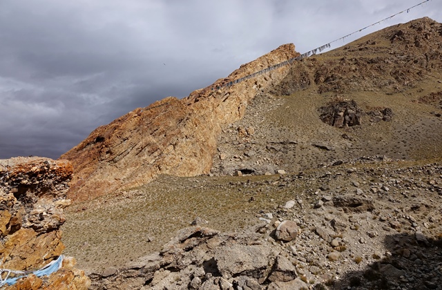
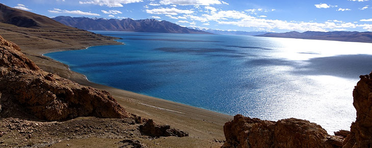
Fig. 1. The mouth of the defile in which Gondak is located. Prayer flags have been strung across this sacred site by local villagers. The ruins are at the base of the orange formation and two-thirds of the way up its inner (right) side.
The location of Gondak is not obvious. It is hidden from view in a defile and is only apprehended when one is nearly upon it. The site is elevated high above the trail (now also a road) that runs along the east shore of Lake Dangra. Furthermore, the main complex of buildings is stacked on a steep slope and is not easily approached, giving it a relatively strong defensive aspect. Lake Dangra is situated in the central Changthang, a sprawling geographical region of Upper Tibet. It falls under the jurisdiction of Nyima County, TAR, formerly the Naktshang (Nag-tshang) district of Tibet (Bod).
It appears that Gondak primarily had a religious function where adepts or monks could congregate and carry out their activities. Depending on the period of occupation, these may have included archaic ritual performances (pre-1000 CE) as well as practices associated with the Yungdrung Bon religion (prevailing in the region for the last 1000 years). Religious functions are indicated by caves with various ritual appointments, a lack of agricultural land, the difficult terrain, and the oral tradition of the site. According to local luminaries interviewed, the cluster of residential structures on the slopes are the remains of a Zhang Zhung-period religious center known as a sekhar (gsas-mkhar / sad mkhar). It is said that this center was once under the authority of a figure called Gondak Tripa (Mgon-bdag khri-pa). It is not known to which period this tradition refers, but heads of major monasteries in Tibet are still called throne holders (khri-pa).
There are a few old barley plots on lake terraces below the defile but these are no longer used for a want of water, say local residents. However, there is intermittent running water in the bottom of the defile at Gondak, furnishing the site with this essential resource. According to the oral tradition, the various watercourses around Lake Dangra were once much more prolific. Residents from the agrarian settlements of Lake Dangra observe that the water they depend on for barley cultivation is steadily dwindling, calling into question an ancient way of life. On the east side of Lake Dangra streams are fed by the 6000-m-high range of mountains enclosing that flank of the lake basin. However, only vestiges of glaciers and permanent snow fields remain in these mountains, threatening what water is left for human use.
The large limestone formation towering above Lake Dangra that hosts Gondak is divided into three parts by gorges, the dwelling place of a trinity of protector gods known as Gonpo Namsum (Three Defenders). The three gods referred to in the trinity carry what are believed to be Zhang Zhung names: Walchen Gekhö (Dbal-chen ge-khod) Kuchi Mangke (Ku-byi mang-ske) and Ati Muwer (A-ti mu-wer). The full name of the trinity is Achen Gonpo Namsum (A-chen mgon-po rnam-gsum). According to senior figures at Lake Dangra I interviewed in the 1990s, the word Achen is of Zhang Zhung origins. While this may possibly be the case, this term is well known in the Yungdrung Bon religion, carrying connotations of primality, purity and divinity, as represented in the Tibetan letter A.
Like the gods whose names were lent to the formation in which it is located, Gondak is said by Lake Dangra residents to be of Zhang Zhung origins. Although my two surveys of the site could not confirm the Zhang Zhung (pre-7th century CE) antiquity of Gondak, architectural features of the ruined buildings indicate that it was founded no later than the Early Historic period (650–1000 CE). The use of stone corbels and bridging stones for the roof, the semi-subterranean aspect of buildings, massive revetments, and the altitudinous location on a steep slope are architectural and locational traits associated with archaic era (pre-1000 CE) constructions in Upper Tibet. A deeper antiquity for the site cannot be adduced from the visible remains but it cannot be ruled out either.
There is also evidence for a later occupation of Gondak connected to the Yungdrung Bon religion. This occupation occurred after 1000 CE (and seems to have continued for centuries). It is probably associated with a mystic mind training school known as Dzokchen (Rdzogs-chen).* According to the local oral tradition, a saint named Dangra Sherab Rinchen (Dang-ra shes-rab rin-chen; may have lived in the 14th century CE) resided in a cave in the lower portion of Gondak. This individual belonged to a lineage of Bon lamas known as Guru (Gu-ru), which in recent years has almost become extinct. Structural evidence preserved at Gondak suggests that the later historical occupation of the site was not nearly as extensive as the earlier phase.
Several kilometers north of Gondak is the much more famous Bon Dzokchen site of Yungdrung Lhatse (G.yung-drung lha-rtse), which also rises high above Lake Dangra. Yungdrung Lhatse was founded in the 11th century by the great Dzokchen practitioner Shengyal Lhatse (Gshen-rgyal lha-rtse). This site remained a prime place of retreat at Lake Dangra for many centuries. Although the large cave at Yungdrung Lhatse may well have a very long history behind it, there are no significant traces of archaic structures there. On this site, see my Divine Dyads (LTWA: 1997), pp. 390–393; March 2014 Flight of the Khyung.
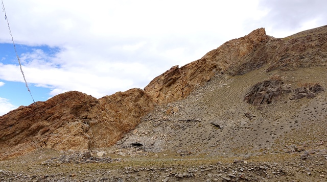
Fig. 2. The shrine complex on a bench (foreground) and ruins of the upper residential complex on slope paralleling the middle reaches of the orange rock formation, a tall rib of limestone. The dark-colored outcrop in the middle of the slope (right side of photograph) also hosted residential structures.
Fig. 3. A view of residential ruins on the upper slope of Gondak. Both caves and the remains of freestanding structures can be seen. The prayer flags were hung by local people who consider the caves a sacred historical site.
Gondak can be divided into four sectors:
1) Shrine complex set on a bench elevated above the bottom of the defile (4715 m)*
2) Two caves at the base of slope (4720 m) and rock shelter (4735 m)
3) Upper residential complex of caves, buildings and shrines planted on the slope that runs along the north side of the defile (4752–4775 m).
4) Residential complex at foot of a grey outcrop (4743 m)
Note: all elevation figures given in this article are estimates based on uncalibrated GPS values.
Gondak shrine complex
The bench near the bottom of the Gondak defile is relatively level and covers around 7500 m². On the west edge of this bench overlooking the lake and road is a ruined shrine complex.* The slopes below the shrine complex are vertical in places, cutting it off from view to those on the road or old pilgrim’s trail. The complex consists of four cubic masonry structures arrayed in an L-shaped pattern. The shrines were aligned to have maximum exposure to the Lake Dangra (not in the cardinal directions), suggesting that they may have been used in the propitiation of its goddess, a figure now known as Dangra Lekyi Wangmo Che (Dang-ra las kyi dbang-mo che). There are a number of shrines dedicated to this goddess in the agricultural villages of Lake Dangra. She is worshipped to ensure rain and an adequate supply of irrigation water, the fertility of people and livestock, prosperity and good fortune, and as a religious protectress.
During my initial survey of Gondak I was under the impression that this shrine complex was the remains of a residential edifice. In fact, such groups of ruined cubic shrines are fairly common in Upper Tibet. See, for example, June 2014 Flight of the Khyung.
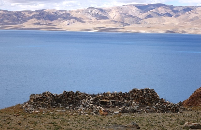
Fig. 4. The ruined shrine complex at Gondak overlooking Lake Dangra. In the foreground are the walls of a now-defunct pastoral shelter built with stones pilfered from the archaeological monument.
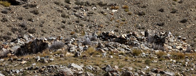
Fig. 5. The shrine complex as seen from the west side. As is seen in this photograph, most of it has been destroyed.
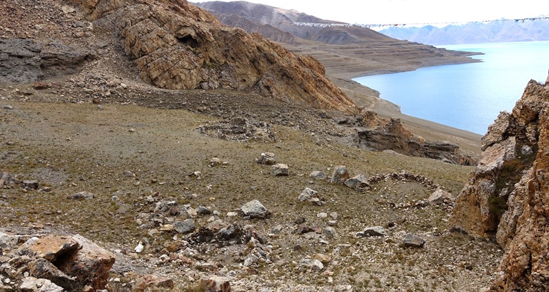
Fig. 6. The bench with the shrine complex (center of image) and other ruined pastoral structures (foreground and right side). Note how the terrain plummets from the bench to join lake terraces below. Lake terraces, the result of a receding shoreline over thousands of years (in the Middle and Late Holocene), are visible in the upper right half of the image.
The four cubic shrines of the complex have been gutted and some parts of the structures nearly leveled. The sheer size and design of the shrine complex at Gondak, as well as the lack of inscribed stone plaques and other signs of Yungdrung Bon religious practice, show that it is of archaic construction (pre-1000 CE). This is one of the largest archaic ceremonial complexes at Lake Dangra (but dwarfed by the one at Phyug-tsho grog-po, located further south along the lakeshore). These kinds of shrines are generally known as sekhar (gsas-mkhar) or lhaten (lha-rten).
Sometime in the past, this group of ancient shrines was converted into a sheepfold and herders’ camp. The east wall of the three shrines along the long arm of the L forms the backdrop of the pastoral shelter, the creation of which was highly detrimental to the structural integrity of the ruined shrines. Belonging to an earlier cultural milieu, no effort has been made in the contemporary period to rehabilitate the ruins.
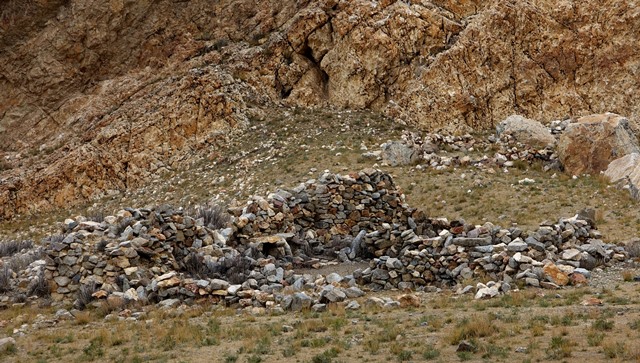
Fig. 7. The shrine complex from the southeast. The vestiges of the cubic structure on the lower left side of the image is the shrine along the short arm of the L-shaped plan of the complex. The low walls in the middle and on the right side are what remains of a pastoral camp.
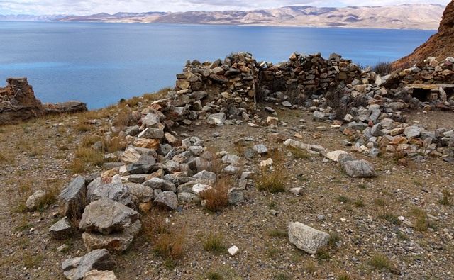
Fig. 8. The shrine on the short arm of the L (middle left) and traces of the south and central shrines along the long arm of the L (middle right and right side). These latter structures were dismantled in order to build the adjoining pastoral camp (foreground).
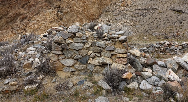
Fig. 9. The shrine of the short arm of the L seen from the south. To the left are the ruins of the south and central shrines along the long arm of the L.
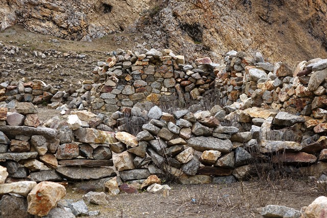
Fig. 10. The cubic shrine of the short arm of the L seen from the north (middle of image) and adjacent walls of the ruined pastoral camp.
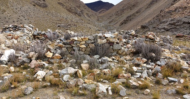
Fig. 11. Traces of the south and central shrines of the long arm of the L (middle) seen from the west. Only tiny coherent wall sections in these two structures have survived. The north shrine of the long arm of the L can be seen on the left side of the image.
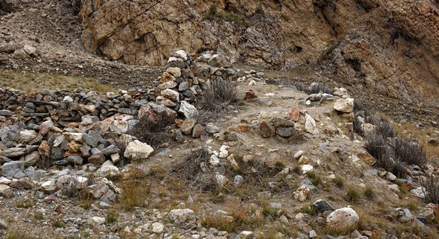
Fig. 12. The north shrine as viewed from the north. It appears that much of it was dismantled in order to build the pastoral camp.
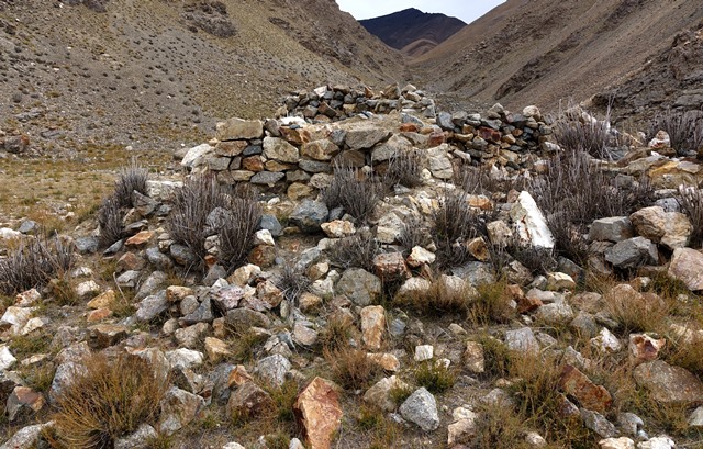
Fig. 13. The north shrine viewed from the west. The gorge running through Gondak is visible in the background.
The cubic shrine making up the short arm of the L measures approximately 2.2 m x 2 m x up to 1.6 m. However, at one time it was somewhat taller. The south shrine of the long arm of the L measures 3.9 m x 3.5 m and the central shrine measures 3.2 m x 3.2 m. These specimens sit next to each other and are mostly flattened. The north shrine along the long arm of the L measures 3.2 m x 3.1 m x up to 2 m. There is a gap of 1.3 m between the central shrine and north shrine.
Caves in the mouth of the defile
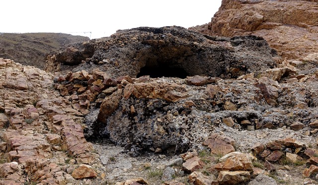
Fig. 14. Small cave in a mass of conglomerate and the remains of a wall on the south side of the defile at Gondak.
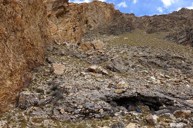
Fig. 15. Cave with façade on the north edge of the bench at Gondak. The upper residential complex is found on the slopes directly above the cave.
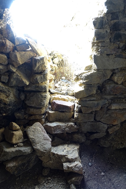
Fig. 16. Entrance and façade of cave on edge of the bench seen from the interior.
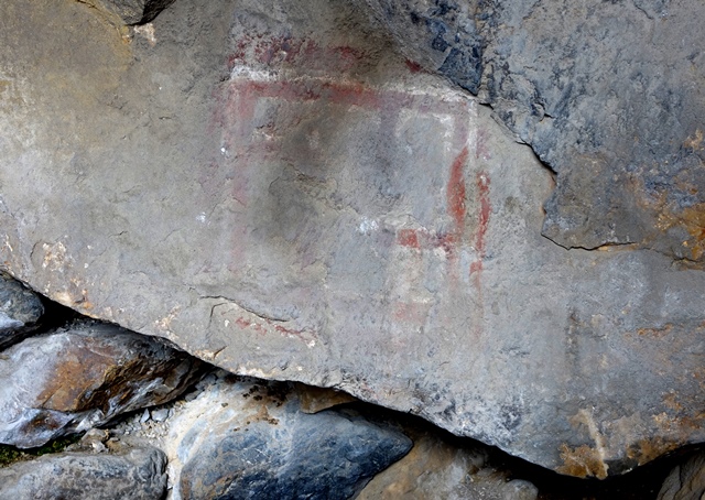
Fig. 17. Bichrome pictograph painted on rear wall of cave on the edge of the bench. This subject consists of a rectangular form, the bottom part of which has been largely obliterated. It is subdivided into at least five quadrate sections. The red lines of this pictograph are paralleled inside and out by thinner white lines.
On the south side of the defile is a small cave directly overlooking Lake Dangra. The faint remains of a façade stand just below the entrance of this cave (4730 m elevation). Another cave (4.5 m x 3.5 m) is located on the north edge of the bench with the shrine complex. There are the remains of a façade around the mouth of this cave. Stone steps lead down from the façade to the interior. On the rear wall of the cave is a single pictograph consisting of a linear subject painted in red ochre (oxides of iron) and a white pigment (probably oxides of calcium). Unfortunately, this pictograph (27 cm in height) is not well preserved, precluding a detailed assessment of its design. The identity and age of the pictograph are unclear; it appears to date to historic times.
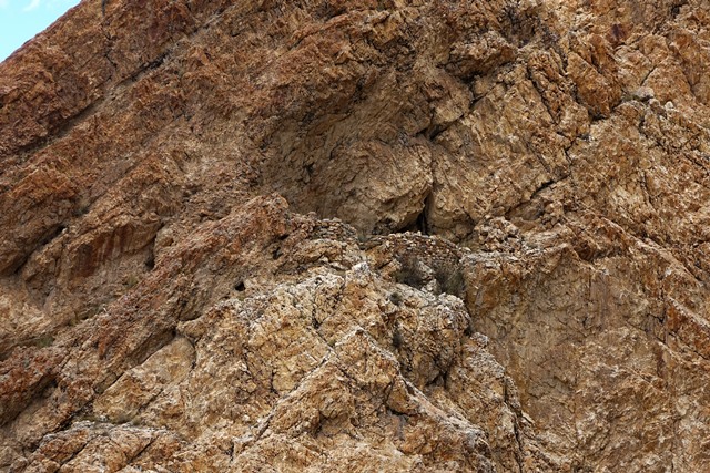
Fig. 18. Ruined wall of rock shelter perched in the orange formation directly above the bench at Gondak.
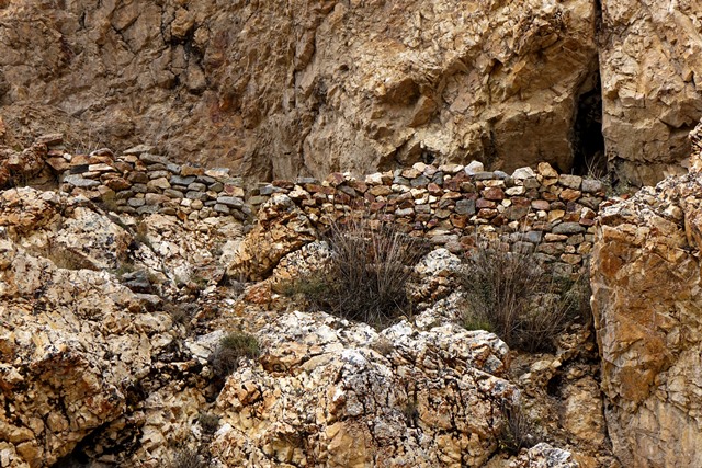
Fig. 19. A close-up of the outer wall of an inaccessible cave shelter at Gondak. This wall probably once enclosed the overhanging formation, creating an entirely enclosed space.
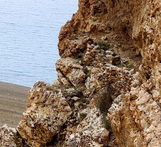
Fig. 20. Another view of the inaccessible rock shelter, rising 200 m above the waters of Lake Dangra.
On the nearly vertical face of the formation, some 60 m northwest of the cave with the steps, are walls. These walls extend for roughly 15 m, enclosing a ledge. This structure is found approximately 20 m above the bench and appears to have had a residential function. Unfortunately, it is no longer readily accessible. The location of this rock shelter and its construction suggest that it dates to the archaic era.
Upper residential complex
The main concentration of residential structures at Gondak is located on a steep slope (approximately 45° gradient) directly above the bench. The upper residential complex is comprised of a contiguous array of ruined edifices appended to caves in the formation. This dispersion (caves excluded) covers approximately 360 m² and contains the carcasses of roughly 14 to 18 buildings/rooms. These structures are now all highly fragmentary, impeding an analysis of their layout and extent. The slope here hugs the long rib of orange limestone just to the west, which forms the north side of the defile. The location of the upper residential complex effectively protects it from north winds.
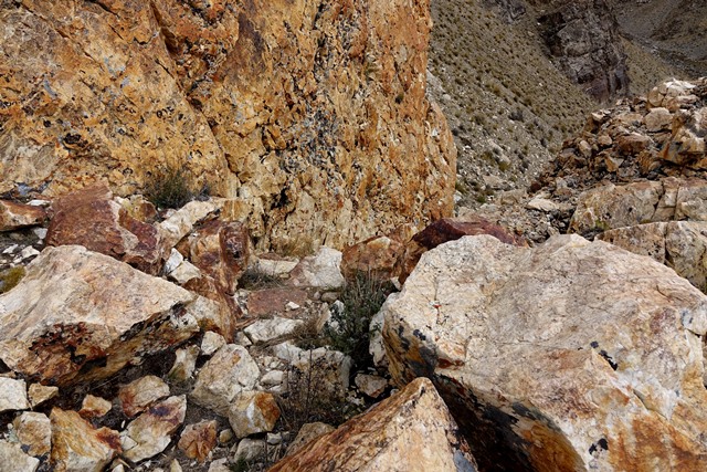
Fig. 21. Old trail passing from the upper slopes to the Dangra lakeside.
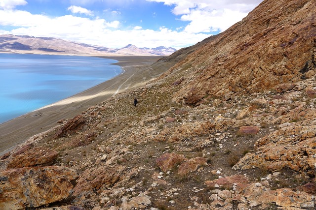
Fig. 22. A partial view of the bench overlooking Lake Dangra. This relatively level area may have served a special purpose for the inhabitants of Gondak. The lake is situated more than 200 m below.
A notch in the formation is reached (4740 m) by ascending the slope from the bench with the shrine complex. An old trail traverses the slope and passes through the gap in the formation, accessing a long narrow shelf suspended high above Lake Dangra. This rocky shelf appears to be accessible only from this single point. From the shelf residents at Gondak could monitor the lakeshore and it furnished an open level area that may possibly have had economic and social functions. However, there are no ancient structural remains visible at this location.
Fig. 23. A view of the upper residential complex of Gondak as seen from the slope below. On the lower left side of the photograph are the remains of a revetment, the lowest structure of the complex. Above the revetment, on the slope along the edge of the rocky formation, are the various structures of the site.
The upper residential complex is situated on the steeply inclined slope above the notch in the formation. It begins at 4752 m and continues upwards to an elevation of 4775 m. The main cluster of structures and caves begins above 4760 m and continues along the axis of the slope for 24 m until meeting the rocky formation that encloses it from above. The mass of residential structures occupies an approximately 20-m-wide breadth of the slope. The dispersion is densest in the west half, near the line of caves. The northeast quarter of the dispersion is devoid of significant structural remains.
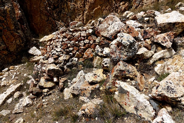
Fig. 24. The lone structure at the bottom of the upper complex, a highly degraded revetment This was part of a more extensive structure at one time. Note the orange climax lichen covering the stones of the wall.
At an elevation of 4752 m there is only one fragmentary revetment or retaining wall remaining on the surface. This structure is built into the slope and is 3.5 m long and 2 m high. This superficial structure exhibits a wall fabric (drystone random rubble) indicative of archaic monuments, and is covered in orange lichen suggesting that it has been undisturbed for a long time. The presence of this feature shows that the upper residential complex was once more extensive, although the structural composition of this lower portion of the complex is questionable. It may have consisted of a defensive wall or another type of delineating structure, a residential building or something else.
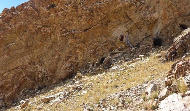
Fig. 25. The main concentration of ruins in the upper complex. On the extreme upper right is a small cave depository for clay figurines. Below it and to the left are caves flanking the upper sector of the site. The cave and ruins in the middle of the image belong to the middle sector, while the more open area downhill is the lower sector. The ruin on the lower left side of the photo is the largest single extant structure at Gondak.
The main dispersion of the upper residential complex begins above 4760 m, directly in line with the lone revetment fragment. The structures of this complex can be divided into three main tiers or sectors: upper, middle and lower.
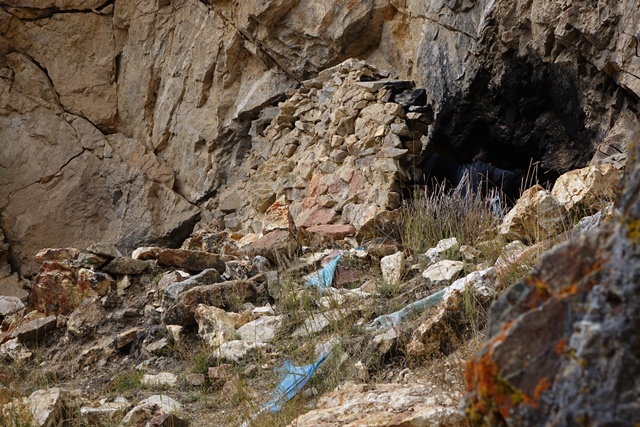
Fig. 26. A partial view of the façade and mouth of the larger cave on the top end of the upper tier of the upper residential complex. The standing wall is of more recent construction, while the jutting base of the wall was once part of an archaic era structure.
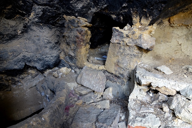
Fig. 27. Masonry and mud platform (right), walled cubbyhole (middle) and berm around the opening of a basement (left) found inside the cave illustrated in fig. 26. Note the stone slab forming the roof of the basement around the opening in the floor.
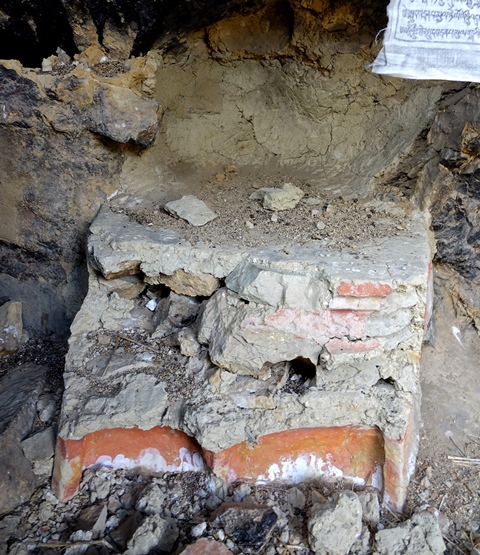
Fig. 28. The masonry and adobe platform with traces of orange (ochre) and white pigments on the exterior faces.
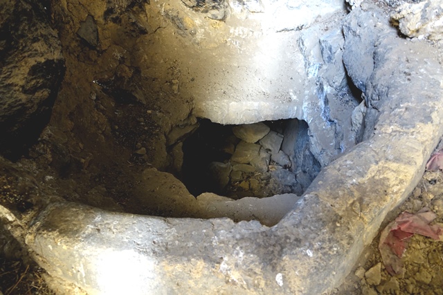
Fig. 29. Opening to the basement with adobe berm around it. This subterranean space may possibly have had ritual functions associated with chthonic spirits.
On the north (upper) end of the upper residential complex is a cave (5.5 m x 2.2 m). It has a partially intact façade up to 2.5 m in height. This masonry front was rebuilt in historical times, as indicated by the crude random rubble texture, thick seams filled with copious amounts of mud mortar and the relatively poor construction. This upper section is only 30–40 cm thick, while the more ancient base of the façade is around 60 cm thick and of a more refined fabric. There is an entranceway (1.2 m x 40 cm) with a stone lintel in this wall. Inside the cave is a mud and masonry platform that may possibly have functioned as an altar. The platform is coated in orange and white pigments. There is also a walled cubbyhole (1 m deep, 70 cm high) in the cave, as well as a basement (70 cm deep, 1.8 m long, 70 cm wide) with a stone slab roof enclosed by an adobe berm. The cubbyhole or cranny must have been used for storage or to enshrine sacred articles. The basement may have functioned to conceal valuables or as a kind of tabernacle. These furnishings probably belong to the archaic era occupation of the site. There are other caves and all-stone corbelled buildings in Upper Tibet with such features. Nevertheless, the heavily blackened ceiling of the cave indicates a period of more recent occupation. Prayer flags strung around the cave show that it is still a place of religious devotion, however infrequent. Although no one has lived at this site in modern times, it is still viewed as the ritual heart of the upper residential complex at Gondak.
Directly above the cave still visited by pilgrims is a much smaller one filled with unbaked clay figurines (tshwa tshwa), a sign of the religious importance of the upper residential complex of Gondak in a later historical context.
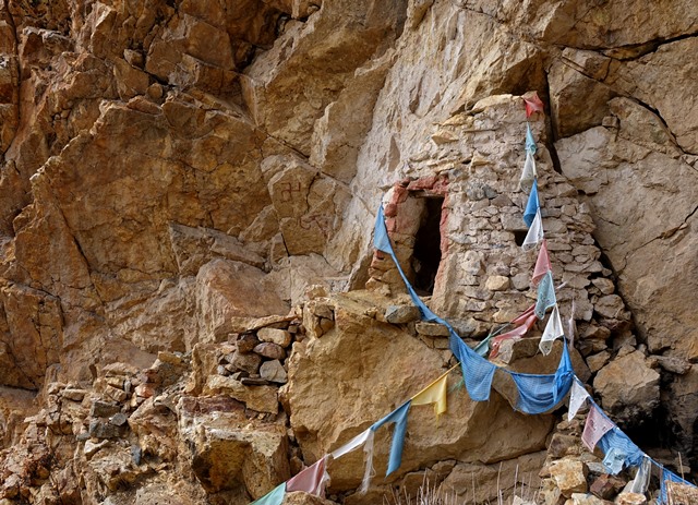
Fig. 30. Cave with ritual functions in formation with pyramidal façade tinted white and red. Note the remains of stone steps leading up to this structure. To the left of the cave a Tibetan letter A and a counterclockwise swastika painted in red ochre are visible.
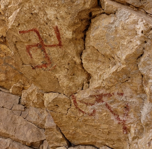
Fig. 31. A close-up of the letter A and swastika on the wall of the formation.
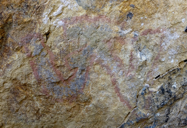
Fig. 32. A letter A on the rear wall of the cave pictured in fig. 30. This letter was skillfully written using red and white pigments.
Near the upper cave of pilgrimage is another cave set about 3 m higher on the west side of the formation. This smaller cave has a pyramidal façade tinted white and a band of red ochre around the entranceway (1m high). This well-preserved façade can probably be ascribed to a later period. The cave is less than 2 m deep. It appears to have functioned as a shrine and did not have residential functions. On the rear wall of this cave a Tibetan letter A (60 cm in width) was written using red and white pigments. This highly worn letter seems to date to the Early Historic period. Above this letter, a more recent Om was written in a beige pigment. On the wall of the formation adjacent to the cave a counterclockwise swastika and the Tibetan letter A (40 cm in height) were painted in red ochre. These two pictographs probably postdate 1000 CE. The subjects chosen for representation are common Tibetan religious symbols, particularly for the Bon tradition. They are laden with doctrinal, mythic and mystic meaning.
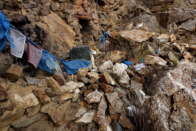
Fig. 33. Highly degraded ruins of rooms belonging to the upper tier of the upper residential complex. Note the pilgrimage cave with entranceway above the ruins.
Fig. 34. One of the corbels in situ that belonged to upper tier residences. This is a telltale sign that these structures possessed an all-stone roof built in the archaic manner.
Directly below the two aforementioned caves are the structural remains of the upper sector. These are comprised of what were once two or three rooms. Jutting out from a large boulder at the base of the cave with furnishings are several stone corbels and a bridging stone, traces of the roof of an edifice. There were at least two rooms in that structure, one of which is east of the intact roof appurtenances. These chambers were deeply built into the slope and the rear wall is largely subterranean. These situational and morphological traits belong to residential structures built entirely of stone in the archaic manner of construction in Upper Tibet.
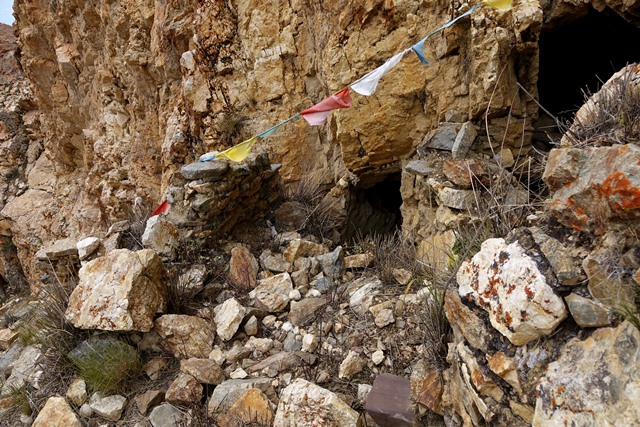
Fig. 35. Remains of the west room of the middle tier of the upper residential complex. In the center of the photograph is the entrance to the adjoining cave. In the middle foreground a reddish corbel juts out from the rear wall. Only small fragments of the forward wall of the room have endured.
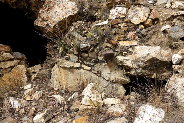
Fig. 36. Rear wall of west room in middle tier. Note the reddish corbel (also seen in fig. 35) and chamber under the rear wall (right side). The entrance to the adjoining cave is on the left side of the photograph.
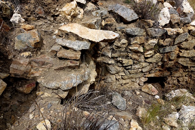
Fig. 37. East room of the middle tier. Corbels protruding from the rear wall and a niche at ground level are visible.
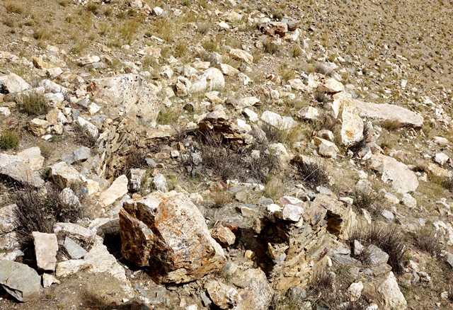
Fig. 38. Overhead view of the east room of the middle tier. The remains of all four walls are visible. On the slope to the east (upper center of image) are traces of what may have been a walled enclosure attached to the edifice.
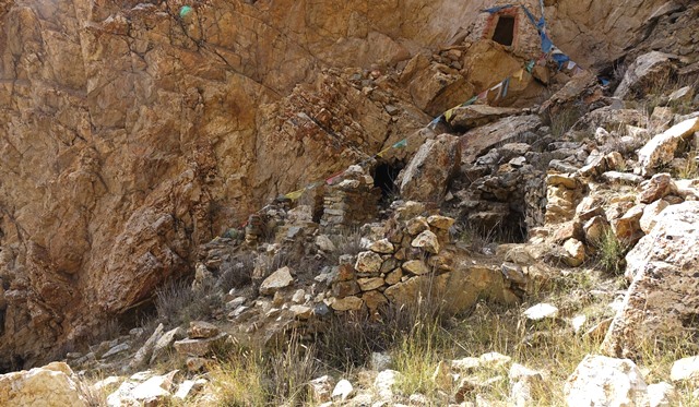
Fig. 39. The west room (middle right) and east room (middle left) of the middle tier. To the left of these rooms are traces of may have been interconnected forward or downslope rooms of the same building.
Immediately below the upper sector is the middle sector, where vestiges of two upper rooms are clearly discernable. Fragments of these rooms include forward portions reaching a maximum height of 2 m. The west room has a corbel protruding from the rear wall and below it an underground chamber (1.5 m x 1.5 m x 1 m). It is not clear whether this chamber had utilitarian or ritual functions. In the east room there is a corbel clinging to a side wall and a niche at current ground level. The rear wall in the east room is 1.5 high and 1.8 m high in the west room, all of which appears to have been underground originally. Both rooms were once deeper but infilling and erosion of the surface have occurred. There were possibly two or three forward rooms just to the south (downhill) of the two better-preserved specimens.
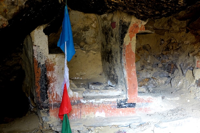
Fig. 40. A stone and adobe ambry in rear of the larger cave of the middle tier, upper residential complex. This structure was painted with three different colored pigments. To the right is an alcove.
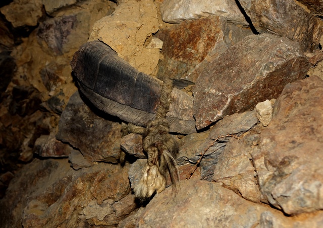
Fig. 41. Horn of a blue sheep stuck into the wall of the large cave of the middle tier. This object was used as a fastening device. Note the animal hair robe attached to it.
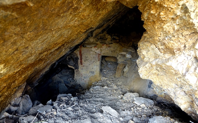
Fig. 42. Smaller cave of middle tier with wall partitioning it into forward and rear chambers. Note the red, beige and white pigments used to paint the partition.
A cave opens up immediately west of the west room in the middle tier. There is an adobe and stone ambry or closet in the rear of this cave (7 m x 5 m). It is painted in beige, red and black pigments. Adjacent to this closet is an alcove that once had stone shelves. These facilities may possibly have had specialized religious functions. It could not be determined if they were archaic era features or of more recent construction. Pieces of argali and blue sheep horns are stuck into the walls and ceiling of the cave. These were used as fasteners from which things (like a drum) could be hung. A smaller cave (5 m x 2.5 m) is situated directly below the larger cave. It was also accessed from the west room. A wall covered in yellow, red and beige pigments divides the cave into rear and forward chambers.
It appears that these caves constituted the inner sanctum of the site and the standing walls around them anterooms. Caves lie at the heart of a number of monastic sites built at the foot of rocky formations in Upper Tibet (e.g., Bya-do, Sha-ba brag, Shangs klu-khang, etc.). This represents the continuation in the region of an ancient architectural tradition with non-Buddhist roots.
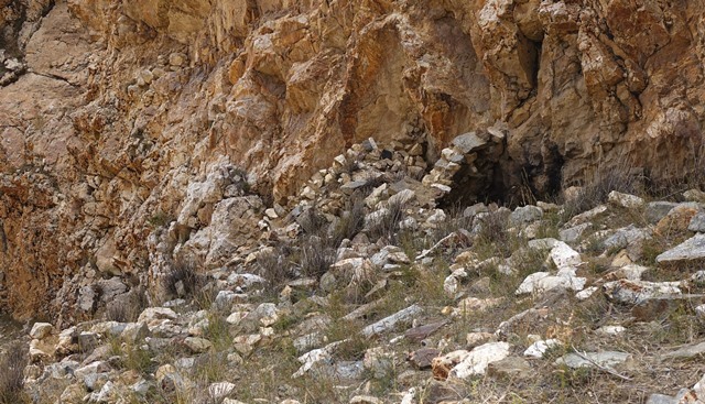
Fig. 43. Two of the most prominent structures of the lower tier, upper residential complex. A room built into the formation is on the middle right side of the photograph. The structure to its left contains the only intact entranceway in an archaic era building of the site.
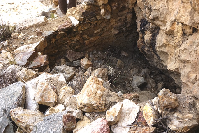
Fig. 44. Room built in a recess in the formation, lower tier. The remains of corbelling that once encircled the top of the walls are visible.
There are highly degraded structural remains on the slope between the middle and lower tiers, but it is not clear if these represent rooms or more minor structures. Below the cave partitioned into two chambers is a detached room tucked into the formation. This room (3 m x 2.5 m) dominates the upper section of the lower tier. Its largely intact walls are deeply set below the slope. Like other domiciliary structures in the upper residential complex, this one once supported an all-stone corbelled roof. Out on the slope to the east are faint traces of other structures.
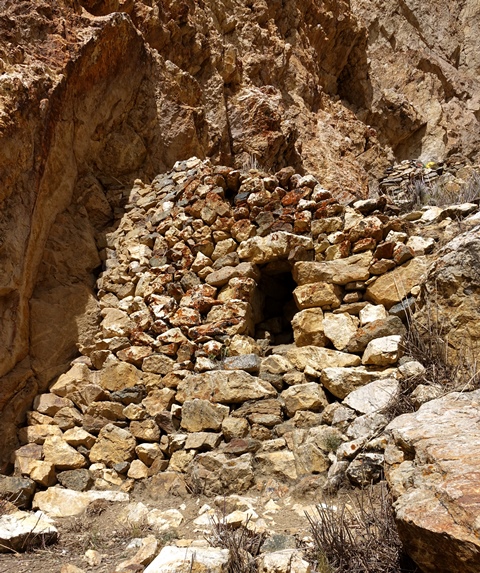
Fig. 45. Forward face of the lowermost recognizable residential structure in the upper residential complex. This wall is punctuated in the middle by an entranceway with a heavy stone lintel.
The forward wall of the structure set below the formation abuts a heavier downslope structure. The rear side of this lower structure is set deeply into the slope but it is now so deteriorated that the dimensions and the number of rooms contained therein are unclear. The forward flank consists of a large wall (4 m in height) embedded in the steep slope. This wall is 1.4 m thick at the top and thicker at the base (mostly submerged under the slope). It once helped support a substantial building. The forward wall is punctuated by a small entranceway (90 cm x 30 cm). The entranceway accessed a lower level chamber that has been entirely engulfed by the slope.
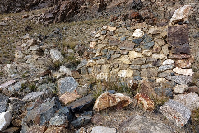
Fig. 46. The two ruined cubic shrines of the upper residential complex seen from downhill.
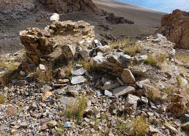
Fig. 47. The twin shrines seen from uphill.
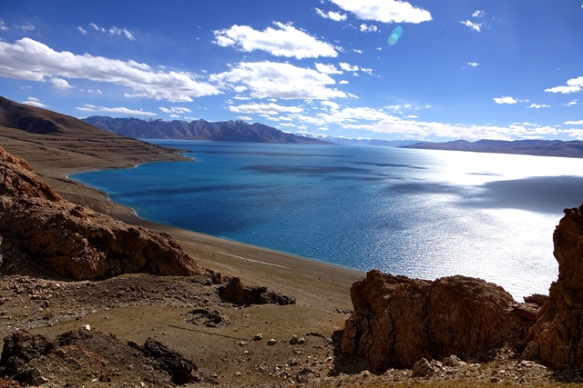
Fig. 48. The view of magnificent Lake Dangra from the twin shrines. In the far distance are the snowy peaks of the Targo (Rta-sgo) range. The shelf with the large shrine complex is visible below the upper slopes. On the lower right side of the photograph is the notch in the formation accessing the lakeside shelf.
Approximately 75 m east of the upper complex are ruins of two cubic shrines (4765 m elevation). These shrines are fully in view of the lake. They are archaic ritual structures of typical construction, masonry shells that once contained a central chamber or repository. The shrines are spaced 40 cm apart from one another and sit on a plinth. There is also a revetment on the south (downhill) side. These twin structures measure 1.5 m by 1.6 m and 1.5 m by 1.2 m and have been reduced to a maximum height of 1.2 m. Presumably, these shrines constituted a ritual/ceremonial component of the upper complex. However, their better-preserved condition may suggest that they were maintained for a longer period than the bulk of residential structures.
Grey outcrop residential complex
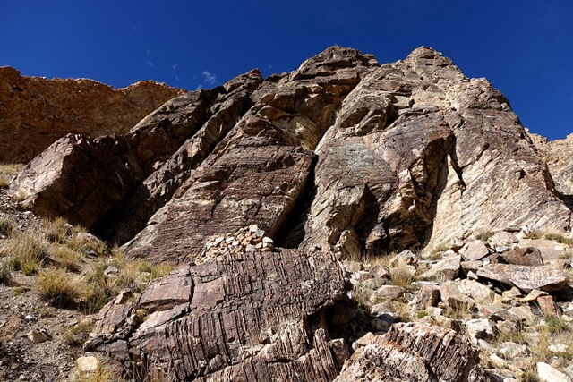
Fig. 49. Grey outcrop with residential ruins at the base. Note the remnants of a wall still clinging to the rock in the foreground. This was part of a forward structure.
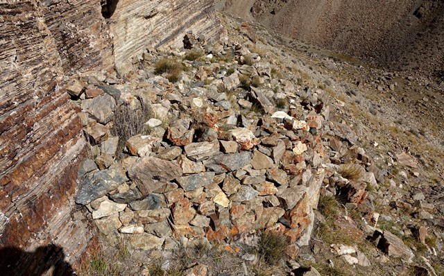
Fig. 50. Wall footings and revetment at the foot of the grey outcrop.
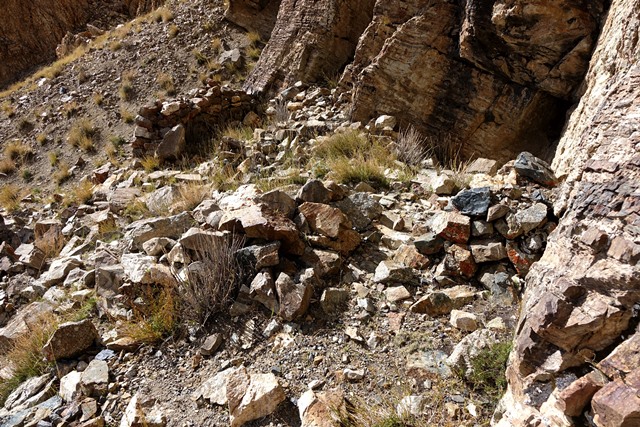
Fig. 51. Another view of what remains of the residential complex at the base of the grey outcrop.
A much smaller residential complex is located about 250 m east of the upper residential complex at lower elevation (4743 m). It sits on the south side of an isolated grey-colored outcrop, where there are good views of Lake Dangra. This highly deteriorated residential structure measures around 12 m by 8 m. It once consisted of at least two or three rooms but is now reduced to crumbling foundations.
Brief Comments on Three Recent Scientific Articles regarding the Peopling of the Tibetan Plateau
This article comments upon three recently published scientific papers that examine questions related to the permanent occupation of the Tibetan Plateau. These works include studies in geochronology and genetics, areas outside my area of expertise. My remarks are therefore restricted to implications for understanding archaeological matters on the Tibetan Plateau raised by these works. No attempt has been made to critique technical parameters or scientific methods relied upon in these highly specialized fields of research.
The three studies reviewed in this article are as follows:
Dongsheng Lu / Haiyi Lou / Kai Yuan / Xiaoji Wang / Yuchen Wang / Chao Zhang / Yan Lu / Xiong Yang / Lian Deng / Ying Zhou / Qidi Feng / Ya Hu /Qiliang Ding / Yajun Yang / Shilin Li / Li Jin / Yaqun Guan / Bing Su / Longli Kang / Shuhua Xu. 2016: Ancestral Origins and Genetic History of Tibetan Highlanders”, in The American Journal of Human Genetics, vol. 99, pp. 580–594.
Meyer, M. C. / Aldenderfer, M. C. / Wang, Z. / Hoffmann, D. L. / Dahl, J. A. / Degering, D. Haas, W. R. / Schlütz, F. 2017: “Permanent human occupation of the central Tibetan Plateau in the early Holocene”, in Science, vol. 355 (no. 6320), 4 pp.+supplement.
F. H. Chen / G. H. Dong / D. J. Zhang / X. Y. Liu / X. Jia / C. B. An / M. M. Ma / Y. W. Xie / L. Barton / X. Y. Ren / Z. J. Zhao / X. H. Wu / M. K. Jones. 2015: “Agriculture facilitated permanent human occupation of the Tibetan Plateau after 3600 B.P.”, in Science, vol. 347 (no. 6219), pp. 248–250+supplement.
http://science.sciencemag.org/content/early/2014/11/19/science.1259172.full
Lu et al. 2016
The Lu et al. article examines the genetic architecture of modern Tibetans by sequencing the genomes of thirty-nine natives (from various regions of the TAR and Sherpas) and thirty-eight Han (from diverse parts of China). This study has the strength of being based on a relatively large sample size and provides an analysis of both Y chromosome and mitochondrial DNA (mtDNA). The Lu et al. study applies whole-genome sequencing to what is known more broadly about the genetic makeup of ancient and modern human populations. This work contradicts certain findings concerning the genetic origins of Tibetans in some less comprehensive scientific articles published in the last decade (see May 2013 Flight of the Khyung).
Lu et al. conclude that the genetic origins of the Tibetans are considerably more ancient and more complex than previously thought, pushing them back to at least 40,000 years before present. A human occupation of the Tibetan Plateau in that period corresponds with the early Upper Paleolithic and the expansion of Homo sapiens to many parts of the Old World. It remains to be seen if the date for the ethnogenesis of Tibetans advanced by the Lu et al. study is borne out by further genomic research, a quickly evolving scientific field.
The evidence presented in the Lu et al. study indicates the presence of both Paleolithic and Neolithic components in the Tibetan gene pool (paternal and maternal lineages), establishing continuities between the prehistoric inhabitants and those of today. The authors have determined that the Tibetan gene pool is composed of approximately 6% non-anatomically modern human haplotypes (including those from Neanderthal, Denisovan, Ust’-Ishim and unknown archaic ancestries). The authors hold that the shared legacy of Tibetan-enriched sequences extends human occupation on the Tibetan Plateau to 38,000 to 62,000 years ago. Their study concludes that these highly differentiated archaic ancestries are likely to represent an early colonization of the Tibetan Plateau, rather than result from introgression brought on by later migrants. It notes that the proportion of genetic material from non-modern humans in the Tibetan genome is relatively high from a worldwide perspective (appears to be higher only in Oceania). Moreover, some of these archaic haplotypes are virtually unique to Tibet. These findings seem to significantly increase the age and complexity of early human occupation on the Tibetan Plateau.
Ancestry analysis carried out by Lu et al. shows that Tibetans share their genetic makeup with East Asians (aprox. 82% of the total), Central Asia and Siberia (aprox. 11%), South Asia (aprox. 6%), and western Eurasia and Oceania (less than 1%). According to the authors, populations having the closest genetic makeup to Tibetans are the Tu and Nakhi, located on the eastern fringe of the Tibetan Plateau. Among lowlanders, the Han are most closely related to Tibetans but there are substantial genetic differences between them. The study found that the Han share less in common with Siberian and South Asian populations and more in common with others from East Asia. Lu et al. observe that Tibetans also exhibit less genetic diversity than the Han, which is probably due to a higher level of geographic isolation. They hold that the Tibetans and Han diverged from a common ancestral population with an average coalescence range of 9000 to 15,000 years. The authors attribute this split to large-scale migrations to the Tibetan Plateau after the Last Glacial Maximum (LGM).
To account for the diverse ancient gene pools constituting the Tibetan genome, Lu et al. propose that a first wave of genetic inflow occurred more than 40,000 years ago. This gave rise to a “Paleolithic melting pot”, the interbreeding of various hominine groups prior to the LGM. This was followed by another wave of migrations to Tibetan Plateau 9000 to 15,000 years ago and a significant admixture of modern human genes of both a Paleolithic and Neolithic pedigree. This latter wave appears to have originated in different times and places, giving rise to the modern Tibetan gene pool.
Meyer et al. 2017
The Meyer et al. article reviews scientific techniques used to date human handprints and footprints preserved in sediments. These prints in stone are found in Chusang, Central Tibet (80 km northwest of Lhasa), at 4270 m above sea level. Using a combination of dating techniques, the footprints and handprints have been shown to be at least 8200 years old and possibly as much as 12,700 years. This dates to a period before agriculture or pastoralism had taken root on the Tibetan Plateau. These findings help fix permanent occupation of the Tibetan heartland to the Paleolithic and Epipaleolithic, a time when the climate of the Tibetan Plateau was considerably more humid and often warmer.
The long distances involved, difficulties in penetrating the Himalayan barrier and high energy expenditure required indicate that the Chusang site was in all probability located too far away for seasonal migrations from lower elevation regions to have been feasible. This contradicts earlier speculation that the Tibetan Plateau was permanently inhabited only 3600 to 5200 years ago (see May 2013 Flight of the Khyung).
How and when people colonized the entire Tibetan Plateau has been examined from a variety of angles over the years but remains a hotly contested subject. Theories of a three-step transition to permanent settlement, agropastoralism as a prerequisite to permanent occupation (see below), and the late divergence of the Tibetan and Han populations (based on analyses of a select portion of the human genome known as the exome) have all been proposed, but scientific data needed to corroborate them have been lacking. However, by developing a geochronology supported by paleoclimatic and archaeological evidence, the Meyer et al. study demonstrates that cold, remoteness, rugged terrain, a relatively low productive capacity of the land, and physiological responses to hypoxia were not barriers to the permanent occupation of Central Tibet prior to 3200 BCE.
Nineteen handprints and footprints were discovered on a single sheet of travertine in the village of Chusang, in 1998. Travertine is a kind of limestone formed from hydrothermal discharges. Petrographic analysis of the prints indicates that they were made by the weight of the human body and not through carving or artifice. Multiple samples of travertine underwent uranium/thorium-230, optically stimulated luminescence and radiocarbon dating as well as palynological analysis. A range of controls were applied to ensure the integrity of the chronometric data obtained.
That the human occupation of the heart of the Tibetan Plateau occurred not in the Neolithic or Bronze Age but earlier in the Paleolithic or Epipaleolithic has huge ramifications for understanding the demographic, cultural and economic processes involved. An earlier occupation of the Tibetan Plateau indicates that it was affected by foragers, those who practiced a hunter-gatherer way of life. This augments the scope for endogenous processes to account for subsequent cultural and technological developments, rather than necessarily postulating extraneous peoples and events as exclusive agents of occupation and change.
Chen et al. 2015
Chen et al. furnish a succinct account of the chronology and distribution of agriculture in prehistoric northeastern Tibet (NETP). This is the work’s greatest strength. The authors also argue that while the first villages in Tibet appeared as early as 5200 years ago, circa 1600 BCE, a new type of agropastoral economy facilitated the permanent settlement of the Tibetan Plateau at elevations above 3200 m. The authors do not at all discuss the pastoral part of this equation in their work.
The title of the Chen et al. article is misleading, as the data considered are almost entirely restricted to the northeastern corner of the Tibetan Plateau and adjoining areas of northwest China. In their study, the authors provide a map of prehistoric sites on the Tibetan Plateau (fig. 1), including those dating from the Paleolithic and Neolithic-Bronze Age. More than sixty sites of this latter composite category are designated in Upper Tibet but they are not named or discussed in the article.
There is some confusion in the Chen et al. work as to what constitutes the Tibetan Plateau in a geographic sense, as it encompasses areas below 2500 m in elevation. This lower elevation fringe region figures heavily in their statistical analysis of agriculture (thirty-seven of fifty-three sites enumerated are situated below 2527 m). The authors believe that prior to 1600 BCE, agriculture in northeastern Tibet was dominated by the cultivation of millets in areas below 2500 m. However, this analysis excludes much of northeastern Tibet for a want of archaeological data. When such data is forthcoming, a less geographically constrained picture of agriculture in the region may possibly emerge.
Chen et al. with little remark assume that settlement of the Tibetan Plateau could only take place with the agricultural production of food. This unsubstantiated claim brackets the discussion of their findings in northeastern Tibet and adjacent lower tracts of the Yellow River valley. However, as we have seen in the above reviews of two other articles, permanent occupation of the Tibetan Plateau is likely to be a good deal older than Chen et al. estimate.
Chen et al. claim that the sustained occupation of the Tibetan Plateau was facilitated by the cultivation of wheat and especially barley. This, they say, replaced seasonal forays by hunter-gathers as the prime mode of human occupation in the region. Despite suggestions to the contrary by the authors, there is no definitive evidence indicating that foragers migrated on a seasonal basis to high elevation Paleolithic and Neolithic sites in northeastern Tibet, nor to other interior portions of the vast Tibetan Plateau. As in many other places in the world, hunter-gatherers on the Tibetan Plateau appear to have gotten on with their lives for thousands of years before the advent of agriculture. It is certainly possible though that the introduction of wheat and barley on a drying and cooling Tibetan Plateau altered the distribution, density and demography of human settlement.
The Chen et al. study maintains that northeastern Tibet “became the principal region of human settlement on the Tibetan Plateau” because this is where nearly three-quarters of prehistoric sites have been discovered. In their assessment, the authors include valleys at 2000–2500 m elevation, on slopes adjacent to the Loess Plateau of the Yellow River drainage system. In addition to questions of territorial extent, there is another potential difficulty with their assessment, rendering it less useful than the authors assume. There has been a bias favoring scientific exploration in the extreme northeast (as compared to hinterland regions of the Tibetan Plateau in the TAR), which partially explains why there is a known concentration of Neolithic and Bronze Age sites in that region. Furthermore, Chen et al. equate the archaeological cultures of the northeastern Tibetan Plateau with Neolithic and Bronze Age cultures of the Loess Plateau. They write, “The NETP constitutes an altitudinal entry point into the higher plateau from the adjacent Loess Plateau, with which it shares a series of Neolithic and Bronze Age material cultures.” The cultures mentioned and dates given for them include late Yangshao (3500–3000 BCE), Majiayao (3300–2000 BCE), Qijia (2100–1600 BCE), Xindian (1400–700 BCE), Kayue (1600–600 BCE), and Nuomuhong (1400–800 BCE). This assumption about the uniformity of archaeological cultures on the Tibetan Plateau and Loess Plateau, however, does not take into consideration regional variability exhibited by the archaeological record, adaptive human ecological processes in different environments and cultural affinities with other parts of the Tibetan Plateau.
Citing brief findings on frost tolerance (Páldi et al. 2001), Chen et al. state that barley typically requires six months from the time of sowing until it is harvested, but this is hardly true of higher elevation regions of Central Tibet and Western Tibet, where many strains of barley mature in 105–140 days. The formal study of maturation rates for barley in an archaeological context could shed light on how settlement patterns on the Tibetan Plateau were affected by agriculture. This is just one of several areas of study that the findings and assumptions of the Chen et al. article encourage.
Next Month: The return of the wild yak!